
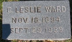
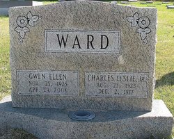
Charles Leslie Ward Sr.
| Birth | : | 18 Nov 1894 Woodfield, Montgomery County, Maryland, USA |
| Death | : | 29 Sep 1939 Gaithersburg, Montgomery County, Maryland, USA |
| Burial | : | St. Luke's Churchyard, Endon, Staffordshire Moorlands District, England |
| Coordinate | : | 53.0812200, -2.1086100 |
frequently asked questions (FAQ):
-
Where is Charles Leslie Ward Sr.'s memorial?
Charles Leslie Ward Sr.'s memorial is located at: St. Luke's Churchyard, Endon, Staffordshire Moorlands District, England.
-
When did Charles Leslie Ward Sr. death?
Charles Leslie Ward Sr. death on 29 Sep 1939 in Gaithersburg, Montgomery County, Maryland, USA
-
Where are the coordinates of the Charles Leslie Ward Sr.'s memorial?
Latitude: 53.0812200
Longitude: -2.1086100
Family Members:
Parent

Spouse
Siblings

Children
Flowers:


Nearby Cemetories:
1. St. Luke's Churchyard
Endon, Staffordshire Moorlands District, England
Coordinate: 53.0812200, -2.1086100
2. St Anne Churchyard
Brown Edge, Staffordshire Moorlands District, England
Coordinate: 53.0832490, -2.1429880
3. St Chad Churchyard
Bagnall, Staffordshire Moorlands District, England
Coordinate: 53.0558430, -2.1082770
4. St Chad Churchyard
Longsdon, Staffordshire Moorlands District, England
Coordinate: 53.0887220, -2.0625850
5. St. Michael and All Angels Churchyard
Horton, Staffordshire Moorlands District, England
Coordinate: 53.1135330, -2.0879040
6. St. Michael's Churchyard Extension
Horton, Staffordshire Moorlands District, England
Coordinate: 53.1139430, -2.0878020
7. St. Philip and St. James Churchyard
Milton, Stoke-on-Trent Unitary Authority, England
Coordinate: 53.0503730, -2.1403780
8. St Bartholomew Churchyard
Norton in the Moors, Stoke-on-Trent Unitary Authority, England
Coordinate: 53.0604630, -2.1595270
9. St Edward the Confessor Churchyard
Cheddleton, Staffordshire Moorlands District, England
Coordinate: 53.0689530, -2.0448230
10. Carmountside Cemetery and Crematorium
Milton, Stoke-on-Trent Unitary Authority, England
Coordinate: 53.0449570, -2.1394910
11. St Edwards Lawn Cemetery
Cheddleton, Staffordshire Moorlands District, England
Coordinate: 53.0744437, -2.0385063
12. Christ Church Churchyard
Biddulph Moor, Staffordshire Moorlands District, England
Coordinate: 53.1220780, -2.1402320
13. Parish church of st saviour smallthorne
Smallthorne, Stoke-on-Trent Unitary Authority, England
Coordinate: 53.0497445, -2.1758707
14. St John the Baptist Churchyard
Wetley Rocks, Staffordshire Moorlands District, England
Coordinate: 53.0409100, -2.0555020
15. Smallthorne Cemetery
Smallthorne, Stoke-on-Trent Unitary Authority, England
Coordinate: 53.0480310, -2.1765950
16. Burslem Cemetery
Burslem, Stoke-on-Trent Unitary Authority, England
Coordinate: 53.0463020, -2.1747030
17. Leek Cemetery
Leek, Staffordshire Moorlands District, England
Coordinate: 53.1000880, -2.0248680
18. St Edward the Confessor Churchyard
Leek, Staffordshire Moorlands District, England
Coordinate: 53.1068190, -2.0266150
19. St. Lawrence Churchyard
Biddulph, Staffordshire Moorlands District, England
Coordinate: 53.1281320, -2.1659070
20. St Luke Churchyard
Leek, Staffordshire Moorlands District, England
Coordinate: 53.1061400, -2.0191430
21. St. James the Apostle Churchyard
Newchapel, Newcastle-Under-Lyme Borough, England
Coordinate: 53.0874630, -2.2069790
22. St. Mary's Churchyard
Bucknall, Stoke-on-Trent Unitary Authority, England
Coordinate: 53.0240220, -2.1424430
23. Holy Trinity Churchyard
Hanley, Stoke-on-Trent Unitary Authority, England
Coordinate: 53.0297350, -2.1672050
24. Abbey of St Mary
Abbey Hulton, Stoke-on-Trent Unitary Authority, England
Coordinate: 53.0200000, -2.1300000