

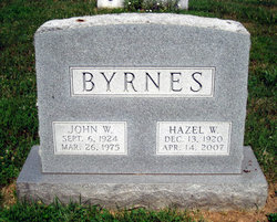
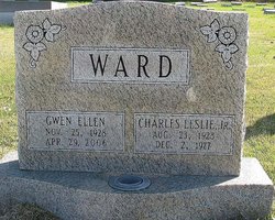
Hazel Young Ward Byrnes
| Birth | : | 13 Dec 1920 Gaithersburg, Montgomery County, Maryland, USA |
| Death | : | 14 Apr 2007 Gaithersburg, Montgomery County, Maryland, USA |
| Burial | : | St. Peter's Churchyard, Kimberley, South Norfolk District, England |
| Coordinate | : | 52.5958100, 1.0572070 |
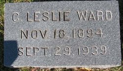
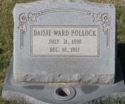
| Description | : | Spouse: Ensign William O. Young. John W. Byrnes. Parents: Charles L. and Daisy E. Ward. |
frequently asked questions (FAQ):
-
Where is Hazel Young Ward Byrnes's memorial?
Hazel Young Ward Byrnes's memorial is located at: St. Peter's Churchyard, Kimberley, South Norfolk District, England.
-
When did Hazel Young Ward Byrnes death?
Hazel Young Ward Byrnes death on 14 Apr 2007 in Gaithersburg, Montgomery County, Maryland, USA
-
Where are the coordinates of the Hazel Young Ward Byrnes's memorial?
Latitude: 52.5958100
Longitude: 1.0572070
Family Members:
Parent
Spouse
Siblings
Flowers:


Nearby Cemetories:
1. St. Peter's Churchyard
Kimberley, South Norfolk District, England
Coordinate: 52.5958100, 1.0572070
2. St. Mary's Churchyard
Deopham, South Norfolk District, England
Coordinate: 52.5788950, 1.0377920
3. St Mary's Churchyard
Carleton Forehoe, South Norfolk District, England
Coordinate: 52.6100400, 1.0847490
4. All Saints Churchyard
Runhall, South Norfolk District, England
Coordinate: 52.6209876, 1.0390341
5. St. George's Churchyard
Hardingham, Breckland Borough, England
Coordinate: 52.6058090, 1.0040050
6. St. Peter and St. Paul Churchyard
Barnham Broom, South Norfolk District, England
Coordinate: 52.6281830, 1.0749820
7. St. Botolphs Churchyard
Morley Saint Botolph, South Norfolk District, England
Coordinate: 52.5601960, 1.0512010
8. St. Andrew's Churchyard
Deopham, South Norfolk District, England
Coordinate: 52.5635040, 1.0224710
9. St Paul's Church Thuxton
Dereham, Breckland Borough, England
Coordinate: 52.6239060, 1.0013630
10. St Botolphs
Barford, South Norfolk District, England
Coordinate: 52.6287000, 1.1118000
11. St. Andrew's Churchyard
Hingham, South Norfolk District, England
Coordinate: 52.5791660, 0.9825900
12. St. Peter's Churchyard
Reymerston, Breckland Borough, England
Coordinate: 52.6144500, 0.9827500
13. St. Peter's Chapel
Morley Saint Botolph, South Norfolk District, England
Coordinate: 52.5464700, 1.0416520
14. St. Margaret's Churchyard
Garvestone, Breckland Borough, England
Coordinate: 52.6264200, 0.9889550
15. Hingham Cemetery
Hingham, South Norfolk District, England
Coordinate: 52.5759750, 0.9773700
16. All Saints, Welborne
South Norfolk District, England
Coordinate: 52.6496860, 1.0546670
17. All Saints Churchyard
Mattishall, Breckland Borough, England
Coordinate: 52.6498440, 1.0551390
18. St. Andrew's Churchyard
Colton, South Norfolk District, England
Coordinate: 52.6407700, 1.1089300
19. St Andrew Churchyard
Southburgh, Breckland Borough, England
Coordinate: 52.6041430, 0.9568180
20. St. Mary's Churchyard
Marlingford, South Norfolk District, England
Coordinate: 52.6310660, 1.1416800
21. All Saints' Churchyard
Mattishall, Breckland Borough, England
Coordinate: 52.6580670, 1.0346230
22. All Saints & St Mary Churchyard
Great Melton, South Norfolk District, England
Coordinate: 52.6108700, 1.1602200
23. Mattishall cemetery
Mattishall, Breckland Borough, England
Coordinate: 52.6597100, 1.0353800
24. All Saints Churchyard
East Tuddenham, Breckland Borough, England
Coordinate: 52.6602410, 1.0813620