
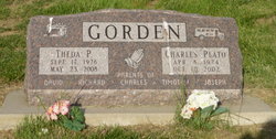
Charles Plato Gorden
| Birth | : | 8 Apr 1924 Dow City, Crawford County, Iowa, USA |
| Death | : | 10 Oct 2002 Denison, Crawford County, Iowa, USA |
| Burial | : | Hāwera Cemetery, Hāwera, South Taranaki District, New Zealand |
| Coordinate | : | -39.5897900, 174.2945500 |
| Plot | : | New Section, block 3 |
| Description | : | Charles Plato Gorden was born April 8, 1924, the son of Ellet and Stella Datterl Gorden. He died Thursday, October 10, 2002, at the Crawford County Memorial Hospital in Denison at the age of seventy-eight. Charles was born on the family farm near Dunlap and received his elementary education at the Boyer No. 7 Country School. On September 25, 1944, Charles was united in marriage to Theda Manchester at the Methodist Parsonage in Dunlap. The couple settled on his family farm with his parents and were blessed with the birth of five children. Charles farmed with his family and for other area... Read More |
frequently asked questions (FAQ):
-
Where is Charles Plato Gorden's memorial?
Charles Plato Gorden's memorial is located at: Hāwera Cemetery, Hāwera, South Taranaki District, New Zealand.
-
When did Charles Plato Gorden death?
Charles Plato Gorden death on 10 Oct 2002 in Denison, Crawford County, Iowa, USA
-
Where are the coordinates of the Charles Plato Gorden's memorial?
Latitude: -39.5897900
Longitude: 174.2945500
Family Members:
Parent
Spouse

Siblings
Children
Flowers:


Nearby Cemetories:
1. Hāwera Cemetery
Hāwera, South Taranaki District, New Zealand
Coordinate: -39.5897900, 174.2945500
2. Tiwhaiti Urupa (Taiporohenui Marae)
Hāwera, South Taranaki District, New Zealand
Coordinate: -39.5741843, 174.3216120
3. Waihi Cemetery and Redoubt
Normanby, South Taranaki District, New Zealand
Coordinate: -39.5444930, 174.2566820
4. Te Utinga Urupā
Normanby, South Taranaki District, New Zealand
Coordinate: -39.5330847, 174.2761055
5. Ohawe Military Cemetery
Ohawe Beach, South Taranaki District, New Zealand
Coordinate: -39.5835138, 174.2003758
6. Weri Weri Urupa Aotearoa Marae
Okaiawa, South Taranaki District, New Zealand
Coordinate: -39.5190700, 174.2206700
7. Okaiawa Cemetery
Okaiawa, South Taranaki District, New Zealand
Coordinate: -39.5310220, 174.2042180
8. Manutahi Cemetery
Manutahi, South Taranaki District, New Zealand
Coordinate: -39.6594677, 174.3924181
9. Manaia Cemetery
Manaia, South Taranaki District, New Zealand
Coordinate: -39.5575010, 174.1354470
10. Motuawa Urupā Waiokura Marae
Manaia, South Taranaki District, New Zealand
Coordinate: -39.5388010, 174.1438990
11. Manaia Redoubt
Manaia, South Taranaki District, New Zealand
Coordinate: -39.5461557, 174.1364306
12. Te Ngutu o te Manu Battlesite Memorial
Kapuni, South Taranaki District, New Zealand
Coordinate: -39.4876351, 174.1838147
13. Eltham Cemetery
Eltham, South Taranaki District, New Zealand
Coordinate: -39.4197140, 174.3251260
14. Kaponga Cemetery
Kaponga, South Taranaki District, New Zealand
Coordinate: -39.4312210, 174.1553160
15. Patea General Cemetery
Patea, South Taranaki District, New Zealand
Coordinate: -39.7447980, 174.4685340
16. Otakeho Cemetery
New Plymouth, New Plymouth District, New Zealand
Coordinate: -39.5492080, 174.0051880
17. Pioneer Cemetery
Stratford, Stratford District, New Zealand
Coordinate: -39.3359800, 174.2929000
18. Kopuatama Cemetery
Stratford, Stratford District, New Zealand
Coordinate: -39.3364400, 174.3364500
19. Pihama Cemetery
Pihama, South Taranaki District, New Zealand
Coordinate: -39.5075300, 173.9285600
20. Midhirst Cemetery
Midhirst, Stratford District, New Zealand
Coordinate: -39.2913640, 174.2724620
21. Midhirst Old Cemetery
Midhirst, Stratford District, New Zealand
Coordinate: -39.2911920, 174.2731980
22. Waverley Cemetery
Waverley, South Taranaki District, New Zealand
Coordinate: -39.7675900, 174.6292700
23. Opunake Cemetery
Opunake, South Taranaki District, New Zealand
Coordinate: -39.4515370, 173.8458110
24. Inglewood Cemetery
Inglewood, New Plymouth District, New Zealand
Coordinate: -39.1554140, 174.2145930