
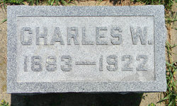

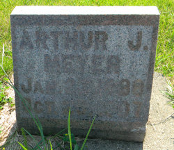
Charles Wilhelm Meyer
| Birth | : | 15 Jun 1883 |
| Death | : | 29 Mar 1922 |
| Burial | : | St. Andrew's Churchyard, Apley, West Lindsey District, England |
| Coordinate | : | 53.2613400, -0.3390200 |
frequently asked questions (FAQ):
-
Where is Charles Wilhelm Meyer's memorial?
Charles Wilhelm Meyer's memorial is located at: St. Andrew's Churchyard, Apley, West Lindsey District, England.
-
When did Charles Wilhelm Meyer death?
Charles Wilhelm Meyer death on 29 Mar 1922 in
-
Where are the coordinates of the Charles Wilhelm Meyer's memorial?
Latitude: 53.2613400
Longitude: -0.3390200
Family Members:
Parent
Spouse
Siblings
Children
Flowers:


Nearby Cemetories:
1. St. Andrew's Churchyard
Apley, West Lindsey District, England
Coordinate: 53.2613400, -0.3390200
2. St Andrew's Churchyard
Bardney, West Lindsey District, England
Coordinate: 53.2442000, -0.3351800
3. St. Edward's Churchyard
Barlings, West Lindsey District, England
Coordinate: 53.2600000, -0.3890000
4. St. Oswald's Churchyard
Rand, West Lindsey District, England
Coordinate: 53.2970600, -0.3404500
5. St. Giles' Churchyard
Langton by Wragby, East Lindsey District, England
Coordinate: 53.2764400, -0.2777700
6. Barlings Cemetery
Langworth, West Lindsey District, England
Coordinate: 53.2728290, -0.4041870
7. Bardney Abbey
Bardney, West Lindsey District, England
Coordinate: 53.2204000, -0.3336000
8. St. John the Baptist Churchyard
Langworth, West Lindsey District, England
Coordinate: 53.2843900, -0.4086800
9. St. Lawrence Churchyard
Bardney, West Lindsey District, England
Coordinate: 53.2095580, -0.3254380
10. Bardney Cemetery
Bardney, West Lindsey District, England
Coordinate: 53.2078350, -0.3208830
11. All Saints Churchyard
Holton-cum-Beckering, West Lindsey District, England
Coordinate: 53.3167370, -0.3257753
12. All Saints Churchyard
Snelland, West Lindsey District, England
Coordinate: 53.3120800, -0.3812000
13. St. Clement's Churchyard
Fiskerton, West Lindsey District, England
Coordinate: 53.2345500, -0.4315200
14. St. Stephen's Churchyard
Hatton, East Lindsey District, England
Coordinate: 53.2758321, -0.2357834
15. All Saints Churchyard
Gautby, East Lindsey District, England
Coordinate: 53.2359800, -0.2413800
16. St. Peter and St. Paul Churchyard
Reepham, West Lindsey District, England
Coordinate: 53.2518050, -0.4450120
17. Hawthorn Road Cemetery
Reepham, West Lindsey District, England
Coordinate: 53.2489252, -0.4513445
18. Scothern Cemetery
Scothern, West Lindsey District, England
Coordinate: 53.2798200, -0.4515500
19. St. Edward the Confessor Churchyard
Sudbrooke, West Lindsey District, England
Coordinate: 53.2717840, -0.4553930
20. St. Germain Churchyard
Scothern, West Lindsey District, England
Coordinate: 53.2835790, -0.4513370
21. St. Peter & St. Paul Churchyard
Cherry Willingham, West Lindsey District, England
Coordinate: 53.2387000, -0.4553800
22. St. John The Baptist Churchyard
Lissington, West Lindsey District, England
Coordinate: 53.3363600, -0.3359800
23. St. Mary's Churchyard
East Barkwith, East Lindsey District, England
Coordinate: 53.3175900, -0.2514400
24. St. Margaret's Churchyard
Bucknall, East Lindsey District, England
Coordinate: 53.2039920, -0.2513250