
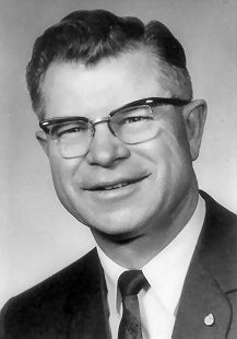
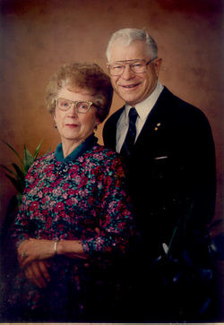

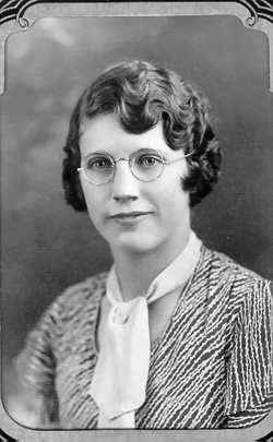
Charles William “C.W.” Kegel
| Birth | : | 26 Sep 1915 Turner, Blaine County, Montana, USA |
| Death | : | 24 Nov 1994 Havre, Hill County, Montana, USA |
| Burial | : | Saint Joseph's Cemetery, Sandusky, Erie County, USA |
| Coordinate | : | 41.4420800, -82.7259500 |
| Description | : | Charles W. Kegel, 79, Havre, died Thursday at a Havre hospital of heart failure. His funeral services will be Monday, at 1 p.m. ay Van Orsdel United Methodist Church, with Masonic rites. Burial will be in Highland Cemetery. Charlie was born on Sept. 26, 1915, at the family homestead near Turner. After graduating from Turner High School and Northern Montana College, he worked as a civil engineer helping build Fresno Dam. In 1940, he went to work for the Great Northern Railway and worked as a station agent. In 1946, he was promoted to train dispatcher, retiring in 1976 after 36 years of... Read More |
frequently asked questions (FAQ):
-
Where is Charles William “C.W.” Kegel's memorial?
Charles William “C.W.” Kegel's memorial is located at: Saint Joseph's Cemetery, Sandusky, Erie County, USA.
-
When did Charles William “C.W.” Kegel death?
Charles William “C.W.” Kegel death on 24 Nov 1994 in Havre, Hill County, Montana, USA
-
Where are the coordinates of the Charles William “C.W.” Kegel's memorial?
Latitude: 41.4420800
Longitude: -82.7259500
Family Members:
Parent
Spouse
Siblings

Children
Flowers:


Nearby Cemetories:
1. Saint Joseph's Cemetery
Sandusky, Erie County, USA
Coordinate: 41.4420800, -82.7259500
2. Saint Marys Cemetery
Sandusky, Erie County, USA
Coordinate: 41.4425011, -82.7285995
3. Calvary Cemetery
Sandusky, Erie County, USA
Coordinate: 41.4383011, -82.7339020
4. Cholera Cemetery
Sandusky, Erie County, USA
Coordinate: 41.4496660, -82.7252970
5. First Cemetery (Defunct)
Sandusky, Erie County, USA
Coordinate: 41.4543770, -82.7216040
6. Grace Episcopal Church Columbarium
Sandusky, Erie County, USA
Coordinate: 41.4547630, -82.7093940
7. Saint Stephen United Church of Christ Columbarium
Sandusky, Erie County, USA
Coordinate: 41.4331790, -82.6861310
8. Oakland Cemetery
Sandusky, Erie County, USA
Coordinate: 41.4267807, -82.6873398
9. Oheb Shalom Cemetery
Perkins Township, Erie County, USA
Coordinate: 41.4199800, -82.6902400
10. Erie County Cemetery
Sandusky, Erie County, USA
Coordinate: 41.4200580, -82.6896760
11. Ohio Veterans Home Cemetery
Sandusky, Erie County, USA
Coordinate: 41.4182940, -82.6881920
12. Venice Cemetery
Margaretta Township, Erie County, USA
Coordinate: 41.4413690, -82.7829920
13. Wilmer Cemetery
Wilmer, Erie County, USA
Coordinate: 41.4008848, -82.7074048
14. Johnson's Island Confederate Cemetery
Marblehead, Ottawa County, USA
Coordinate: 41.5003014, -82.7300034
15. Baum Family Cemetery
Perkins Township, Erie County, USA
Coordinate: 41.3837600, -82.7055420
16. Perkins Cemetery
Sandusky, Erie County, USA
Coordinate: 41.3997002, -82.6505966
17. Osborn Park Cemetery
Sandusky, Erie County, USA
Coordinate: 41.4184280, -82.6361480
18. Old Perkins Cemetery
Perkins Township, Erie County, USA
Coordinate: 41.3851460, -82.6683020
19. Beatty Cemetery (Defunct)
Perkins Township, Erie County, USA
Coordinate: 41.3961370, -82.6508980
20. War of 1812 Battle Site
Mineyahta-on-the Bay, Ottawa County, USA
Coordinate: 41.5140350, -82.7438530
21. Castalia Cemetery
Castalia, Erie County, USA
Coordinate: 41.3957410, -82.8015733
22. Hartshorn Cemetery
Danbury, Ottawa County, USA
Coordinate: 41.5144440, -82.7499530
23. Wolcott Cemetery
Marblehead, Ottawa County, USA
Coordinate: 41.5177994, -82.7403030
24. Sandhill Cemetery
Castalia, Erie County, USA
Coordinate: 41.3616982, -82.7589035