
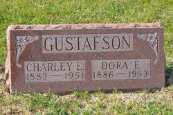
Charley Edwin Gustafson
| Birth | : | 30 Sep 1883 Stratford, Hamilton County, Iowa, USA |
| Death | : | 25 Dec 1951 Des Moines, Polk County, Iowa, USA |
| Burial | : | South Marion Cemetery, Stratford, Hamilton County, USA |
| Coordinate | : | 42.2327995, -93.8735962 |
| Description | : | Des Moines Tribune December 26, 1951 C.E. Gustafson's Rites in Stratford Services for Charles E. Gustafson, 68, of 1363 York St., will be at 1 p.m. Friday at the Methodist church at Stratford, with burial in South Marion Cemetery near Stratford. Mr. Gustafson died of a heart ailment Tuesday at his home following a two-year illness. Born at Stratford, Mr. Gustafson was a serviceman for Green Colonial Furnace Co. for 22 years before retiring two years ago. Surviving are his widow, Dora; two daughters, Mrs. Violet Adlon of Salem, Ore., and Mrs. Genevieve Bayles of Des... Read More |
frequently asked questions (FAQ):
-
Where is Charley Edwin Gustafson's memorial?
Charley Edwin Gustafson's memorial is located at: South Marion Cemetery, Stratford, Hamilton County, USA.
-
When did Charley Edwin Gustafson death?
Charley Edwin Gustafson death on 25 Dec 1951 in Des Moines, Polk County, Iowa, USA
-
Where are the coordinates of the Charley Edwin Gustafson's memorial?
Latitude: 42.2327995
Longitude: -93.8735962
Family Members:
Parent

Spouse

Siblings
Children

Flowers:


Nearby Cemetories:
1. South Marion Cemetery
Stratford, Hamilton County, USA
Coordinate: 42.2327995, -93.8735962
2. Oakwood Cemetery
Stratford, Hamilton County, USA
Coordinate: 42.2942009, -93.9182968
3. Mineral Ridge Cemetery
Ridgeport, Boone County, USA
Coordinate: 42.1749992, -93.9266968
4. Hooks Point Cemetery
Hamilton County, USA
Coordinate: 42.2944530, -93.9199090
5. Hardin Township Cemetery
Hardin Township, Webster County, USA
Coordinate: 42.2411003, -93.9708023
6. Saint Paul Lutheran Cemetery
Boone, Boone County, USA
Coordinate: 42.1700000, -93.8070000
7. Boone County Poor Farm Cemetery
Boone County, USA
Coordinate: 42.1591100, -93.9159000
8. White Cemetery
Boone County, USA
Coordinate: 42.1777992, -93.9636002
9. Lake Center Cemetery
Stanhope, Hamilton County, USA
Coordinate: 42.2482986, -93.7568970
10. Leininger Cemetery
Boone County, USA
Coordinate: 42.1492004, -93.8356018
11. Lawn Hill Cemetery
Stanhope, Hamilton County, USA
Coordinate: 42.2677994, -93.7611008
12. Nesse Cemetery
Hamilton County, USA
Coordinate: 42.3250008, -93.8933029
13. Neese Cemetery
Homer, Hamilton County, USA
Coordinate: 42.3250000, -93.8935000
14. Linn Cemetery
Pilot Mound, Boone County, USA
Coordinate: 42.2045330, -93.9970230
15. Vegors Cemetery
Webster County, USA
Coordinate: 42.3177986, -93.9421997
16. Mackey Cemetery
Boone County, USA
Coordinate: 42.1675000, -93.7565000
17. Runyan Cemetery
Pilot Mound, Boone County, USA
Coordinate: 42.1749992, -94.0015030
18. Saint Pauls Church Cemetery
Jewell, Hamilton County, USA
Coordinate: 42.2490100, -93.7173400
19. Schlicht Cemetery
Fraser, Boone County, USA
Coordinate: 42.1444200, -93.9780100
20. Bass Cemetery
Dayton, Webster County, USA
Coordinate: 42.2966995, -94.0149994
21. Saratoga Cemetery
Stanhope, Hamilton County, USA
Coordinate: 42.3539009, -93.8167038
22. Pilot Mound Cemetery
Pilot Mound, Boone County, USA
Coordinate: 42.1636200, -94.0282600
23. Ellsworth Clear Lake Cemetery
Randall, Hamilton County, USA
Coordinate: 42.2268930, -93.6926200
24. Bass Point Cemetery
Boone, Boone County, USA
Coordinate: 42.0992012, -93.8957977