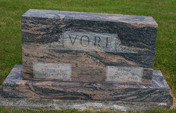
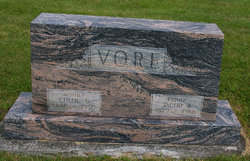
Chloe Dell Miller Vore
| Birth | : | 7 Jan 1880 |
| Death | : | 2 Mar 1950 |
| Burial | : | St Mary the Virgin Churchyard, Church Fenton, Selby District, England |
| Coordinate | : | 53.8243100, -1.2203500 |
frequently asked questions (FAQ):
-
Where is Chloe Dell Miller Vore's memorial?
Chloe Dell Miller Vore's memorial is located at: St Mary the Virgin Churchyard, Church Fenton, Selby District, England.
-
When did Chloe Dell Miller Vore death?
Chloe Dell Miller Vore death on 2 Mar 1950 in
-
Where are the coordinates of the Chloe Dell Miller Vore's memorial?
Latitude: 53.8243100
Longitude: -1.2203500
Family Members:
Parent
Spouse
Siblings
Children
Flowers:
Nearby Cemetories:
1. St Mary the Virgin Churchyard
Church Fenton, Selby District, England
Coordinate: 53.8243100, -1.2203500
2. Holy Trinity Churchyard
Barkston Ash, Selby District, England
Coordinate: 53.8189530, -1.2547620
3. All Saints Churchyard
Saxton, Selby District, England
Coordinate: 53.8261760, -1.2787060
4. St John the Baptist Churchyard Extension
Kirkby Wharfe, Selby District, England
Coordinate: 53.8602100, -1.2321200
5. All Saints Churchyard
Sherburn-in-Elmet, Selby District, England
Coordinate: 53.7956000, -1.2605740
6. St John the Baptist Churchyard
Kirkby Wharfe, Selby District, England
Coordinate: 53.8627400, -1.2320400
7. All Saints Churchyard
Bolton Percy, Selby District, England
Coordinate: 53.8649780, -1.1929000
8. All Saints Churchyard
Ryther, Selby District, England
Coordinate: 53.8478600, -1.1576100
9. Nun Appleton Priory
Appleton Roebuck, Selby District, England
Coordinate: 53.8525000, -1.1561110
10. St Mary the Virgin Churchyard
South Milford, Selby District, England
Coordinate: 53.7771700, -1.2547300
11. Rythergate Cemetery
Cawood, Selby District, England
Coordinate: 53.8356000, -1.1347700
12. All Saints Churchyard
Cawood, Selby District, England
Coordinate: 53.8331970, -1.1235660
13. Lotherton Hall Chapel
Leeds, Metropolitan Borough of Leeds, England
Coordinate: 53.8186380, -1.3189740
14. All Saints Churchyard
Appleton Roebuck, Selby District, England
Coordinate: 53.8734600, -1.1580870
15. Hambleton Cemetery
Hambleton, Selby District, England
Coordinate: 53.7715910, -1.1624600
16. St Mary Churchyard
Hambleton, Selby District, England
Coordinate: 53.7715910, -1.1624600
17. St Wilfrid’s Churchyard
Monk Fryston, Selby District, England
Coordinate: 53.7618300, -1.2349700
18. Monk Fryston Cemetery
Monk Fryston, Selby District, England
Coordinate: 53.7604400, -1.2291700
19. St Leonard Chapelyard
Hazelwood, Selby District, England
Coordinate: 53.8523700, -1.3185500
20. Tadcaster Cemetery
Tadcaster, Selby District, England
Coordinate: 53.8808880, -1.2727280
21. Inghamite Chapel
Tadcaster, Selby District, England
Coordinate: 53.8843580, -1.2644470
22. St John Churchyard
Acaster Selby, Selby District, England
Coordinate: 53.8614750, -1.1283740
23. St Mary the Virgin Churchyard
Tadcaster, Selby District, England
Coordinate: 53.8852300, -1.2624100
24. St. Mary the Virgin Churchyard
Micklefield, Metropolitan Borough of Leeds, England
Coordinate: 53.7971300, -1.3313700

