
| Memorials | : | 26 |
| Location | : | South Milford, Selby District, England |
| Coordinate | : | 53.7771700, -1.2547300 |
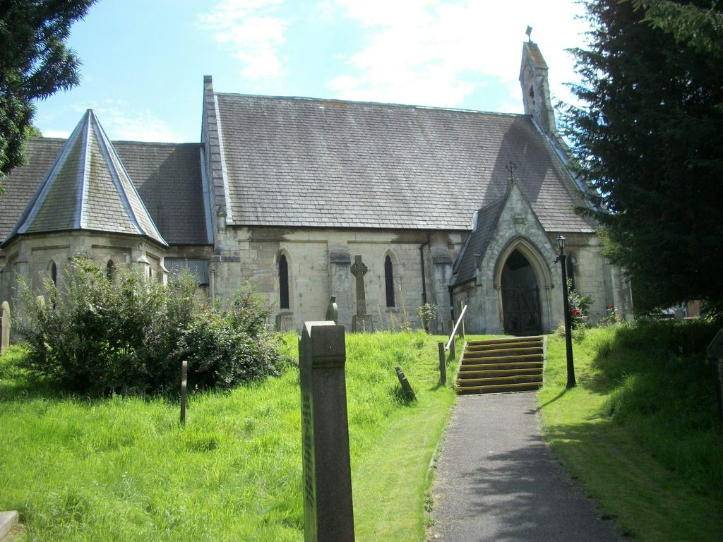
| Description | : | The Church of St Mary, South Milford was consecrated on November 25th 1846 by the then Bishop of Ripon. The parish was formed from that of neighbouring Sherburn-in-Elmet. The land for the church was donated by University Collage, Oxford and additional land by Benjamin Crosland of Milford House. The church was built by Benjamin Bulmer of Thorp Arch using limestone from nearby Huddleston Quarry. The costs were partly funded by two sisters from Parlington Hall, Mary Isabella and Elizabeth Gascoigne. (Source-Church near you). A Churchyard Extension is located across the road from the original churchyard. |
frequently asked questions (FAQ):
-
Where is St Mary the Virgin Churchyard?
St Mary the Virgin Churchyard is located at Westfield Lane South Milford, Selby District ,North Yorkshire , LS25 5APEngland.
-
St Mary the Virgin Churchyard cemetery's updated grave count on graveviews.com?
26 memorials
-
Where are the coordinates of the St Mary the Virgin Churchyard?
Latitude: 53.7771700
Longitude: -1.2547300


Nearby Cemetories:
1. All Saints Churchyard
Sherburn-in-Elmet, Selby District, England
Coordinate: 53.7956000, -1.2605740
2. St Wilfrid’s Churchyard
Monk Fryston, Selby District, England
Coordinate: 53.7618300, -1.2349700
3. Monk Fryston Cemetery
Monk Fryston, Selby District, England
Coordinate: 53.7604400, -1.2291700
4. All Saints Churchyard
Ledsham, Metropolitan Borough of Leeds, England
Coordinate: 53.7622160, -1.3091920
5. St James Churchyard
Fairburn, Selby District, England
Coordinate: 53.7426700, -1.2841000
6. Holy Trinity Churchyard
Barkston Ash, Selby District, England
Coordinate: 53.8189530, -1.2547620
7. St. Mary the Virgin Churchyard
Micklefield, Metropolitan Borough of Leeds, England
Coordinate: 53.7971300, -1.3313700
8. Brotherton United Reformed Church
Brotherton, Selby District, England
Coordinate: 53.7277104, -1.2698131
9. All Saints Churchyard
Saxton, Selby District, England
Coordinate: 53.8261760, -1.2787060
10. St Mary the Virgin Churchyard
Church Fenton, Selby District, England
Coordinate: 53.8243100, -1.2203500
11. St Edward the Confessor Churchyard
Brotherton, Selby District, England
Coordinate: 53.7259200, -1.2709600
12. Hambleton Cemetery
Hambleton, Selby District, England
Coordinate: 53.7715910, -1.1624600
13. St Mary Churchyard
Hambleton, Selby District, England
Coordinate: 53.7715910, -1.1624600
14. St. Peter's Churchyard
Fryston, Metropolitan Borough of Wakefield, England
Coordinate: 53.7355400, -1.3151100
15. St Mary Churchyard
Birkin, Selby District, England
Coordinate: 53.7325000, -1.1979000
16. Lotherton Hall Chapel
Leeds, Metropolitan Borough of Leeds, England
Coordinate: 53.8186380, -1.3189740
17. St. Andrew's Old Churchyard
Ferrybridge, Metropolitan Borough of Wakefield, England
Coordinate: 53.7193380, -1.2748540
18. St. Botolph Churchyard
Knottingley, Metropolitan Borough of Wakefield, England
Coordinate: 53.7108080, -1.2441680
19. United Reformed Churchyard
Knottingley, Metropolitan Borough of Wakefield, England
Coordinate: 53.7104820, -1.2397270
20. St Mary the Virgin Churchyard
Kippax, Metropolitan Borough of Leeds, England
Coordinate: 53.7676520, -1.3686680
21. Ropewalk Methodist Church Burial Ground
Knottingley, Metropolitan Borough of Wakefield, England
Coordinate: 53.7092850, -1.2408320
22. Ferrybridge Cemetery
Ferrybridge, Metropolitan Borough of Wakefield, England
Coordinate: 53.7102530, -1.2795200
23. Castleford New Extension Cemetery
Castleford, Metropolitan Borough of Wakefield, England
Coordinate: 53.7277600, -1.3391000
24. Castleford Old Cemetery
Castleford, Metropolitan Borough of Wakefield, England
Coordinate: 53.7269200, -1.3390300