
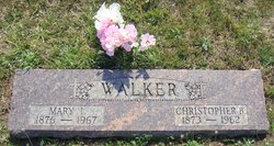
Christopher Bartholomew Walker
| Birth | : | 26 Aug 1873 Silver Lake, Shawnee County, Kansas, USA |
| Death | : | 26 Dec 1962 Mayetta, Jackson County, Kansas, USA |
| Burial | : | Odd Fellows Lawn Cemetery and Mausoleum, Sacramento, Sacramento County, USA |
| Coordinate | : | 38.5585000, -121.5011000 |
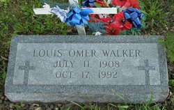
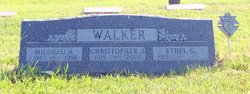
| Description | : | Christopher B. Walker, 89, died Wednesday at the home of his son, Chris J. Walker at Mayetta. He farmed near Mayetta. He was born September 26, 1873 at Silver Lake. Besides his son, Chris, survivors include his widow, Mary, of the home; two other sons, Louis O. Walker, Mayetta and Orval H. Walker, Topeka; a sister, Miss Generesa Walker, Booneville, Mo. and 15 grandchildren. Services were held at 10 a.m. Friday at St. Francis Xavier Catholic Church, Mayetta with burial in Mount Calvary Cemetery, Holton. Pallbearers were John L. Walker, Harold Walker, Gary Walker, Herbert Baker, John Cumming, and Jake... Read More |
frequently asked questions (FAQ):
-
Where is Christopher Bartholomew Walker's memorial?
Christopher Bartholomew Walker's memorial is located at: Odd Fellows Lawn Cemetery and Mausoleum, Sacramento, Sacramento County, USA.
-
When did Christopher Bartholomew Walker death?
Christopher Bartholomew Walker death on 26 Dec 1962 in Mayetta, Jackson County, Kansas, USA
-
Where are the coordinates of the Christopher Bartholomew Walker's memorial?
Latitude: 38.5585000
Longitude: -121.5011000
Family Members:
Parent
Spouse

Siblings
Children
Flowers:


Nearby Cemetories:
1. Odd Fellows Lawn Cemetery and Mausoleum
Sacramento, Sacramento County, USA
Coordinate: 38.5585000, -121.5011000
2. Masonic Lawn Cemetery
Sacramento, Sacramento County, USA
Coordinate: 38.5604720, -121.5032600
3. Sunset Hill Cemetery
Sacramento, Sacramento County, USA
Coordinate: 38.5608000, -121.5037300
4. Sacramento City Cemetery
Sacramento, Sacramento County, USA
Coordinate: 38.5636864, -121.5009537
5. Buddhist Church of Sacramento Nokotsudo
Sacramento, Sacramento County, USA
Coordinate: 38.5639300, -121.4978400
6. National Shrine of Our Lady of Guadalupe Crypt
Sacramento, Sacramento County, USA
Coordinate: 38.5704800, -121.5014400
7. Saint Joseph Cemetery
Sacramento, Sacramento County, USA
Coordinate: 38.5574989, -121.4835968
8. California State Capitol
Sacramento, Sacramento County, USA
Coordinate: 38.5760994, -121.4931488
9. Trinity Episcopal Cathedral Columbarium
Sacramento, Sacramento County, USA
Coordinate: 38.5705500, -121.4723770
10. Holy Ascension Russian Orthodox Cemetery
Sacramento, Sacramento County, USA
Coordinate: 38.5846212, -121.4936736
11. Pho Minh Temple Columbarium
Sacramento, Sacramento County, USA
Coordinate: 38.5340100, -121.4769000
12. New Helvetia Cemetery (Defunct)
Sacramento, Sacramento County, USA
Coordinate: 38.5731600, -121.4639900
13. East Lawn Memorial Park
Sacramento, Sacramento County, USA
Coordinate: 38.5612960, -121.4492760
14. Saint Rose Cemetery (Defunct)
Sacramento, Sacramento County, USA
Coordinate: 38.5208015, -121.4672012
15. Saint Mary's Catholic Cemetery and Mausoleum
Sacramento, Sacramento County, USA
Coordinate: 38.5298900, -121.4261200
16. Sacramento Memorial Lawn Cemetery
Sacramento, Sacramento County, USA
Coordinate: 38.5146484, -121.4380341
17. Home of Peace Cemetery
Sacramento, Sacramento County, USA
Coordinate: 38.5137558, -121.4382782
18. Sacramento County Hospital Cemetery
Sacramento, Sacramento County, USA
Coordinate: 38.5289300, -121.4239100
19. Russian Orthodox Cemetery
Sacramento, Sacramento County, USA
Coordinate: 38.5268800, -121.4244300
20. Sacramento County Cemetery
Sacramento County, USA
Coordinate: 38.5267900, -121.4233700
21. Sacramento County Veterans Memorial Cemetery
Sacramento, Sacramento County, USA
Coordinate: 38.5252838, -121.4239120
22. Tinh Xa Ngoc An Temple Columbarium
Sacramento, Sacramento County, USA
Coordinate: 38.5190200, -121.4159500
23. Elder Creek Cemetery
Florin, Sacramento County, USA
Coordinate: 38.5111008, -121.4169006
24. Kim Quang Temple Columbarium
Sacramento, Sacramento County, USA
Coordinate: 38.5996600, -121.3904700