

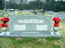
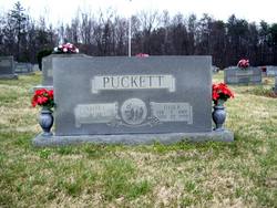
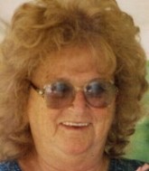
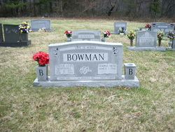
Clara Alice Marshall Bowman
| Birth | : | 7 May 1917 Patrick County, Virginia, USA |
| Death | : | 25 Apr 2002 Mount Airy, Surry County, North Carolina, USA |
| Burial | : | Holy Trinity Churchyard, Loddon, South Norfolk District, England |
| Coordinate | : | 52.5350430, 1.4832560 |
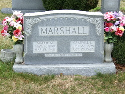
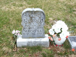
| Description | : | Full name: Clara Alice Marshall Bowman b. Patrick Co., VA d. Mount Airy, Surry Co., NC m. Kermit Bowman 08 Jun 1929 Clara Alice Marshall Bowman, 84, of Mount Airy, N.C., died Thursday, April 25, 2002, at Northern Hospital of Surry County in Mount Airy. She was born in Patrick County on May 7, 1917, and was a daughter of the late Granville and Mallie Puckett Marsjall. She was also preceded in death by her husband, Kermit Bowman; three sons, McKinley Bowman, R.M. Bowman and Paul Bowman; a grandson, Jody Bowman; two sisters, Leatrice Puckett and Uniter Bowman; and two brothers, Avery Marshall and... Read More |
frequently asked questions (FAQ):
-
Where is Clara Alice Marshall Bowman's memorial?
Clara Alice Marshall Bowman's memorial is located at: Holy Trinity Churchyard, Loddon, South Norfolk District, England.
-
When did Clara Alice Marshall Bowman death?
Clara Alice Marshall Bowman death on 25 Apr 2002 in Mount Airy, Surry County, North Carolina, USA
-
Where are the coordinates of the Clara Alice Marshall Bowman's memorial?
Latitude: 52.5350430
Longitude: 1.4832560
Family Members:
Parent

Spouse
Siblings
Children

Flowers:


Nearby Cemetories:
1. Holy Trinity Churchyard
Loddon, South Norfolk District, England
Coordinate: 52.5350430, 1.4832560
2. All Saints Churchyard
Chedgrave, South Norfolk District, England
Coordinate: 52.5409130, 1.4831200
3. St Gregory Churchyard
Heckingham, South Norfolk District, England
Coordinate: 52.5350940, 1.5144710
4. St. Michaels's Church Cemetery
Langley with Hardley, South Norfolk District, England
Coordinate: 52.5552220, 1.4727530
5. Hardley Methodist Chapel
Langley with Hardley, South Norfolk District, England
Coordinate: 52.5577290, 1.4957960
6. St Margaret's Churchyard
Hardley Street, South Norfolk District, England
Coordinate: 52.5522980, 1.5170630
7. St Margaret Churchyard
Hales, South Norfolk District, England
Coordinate: 52.5109380, 1.5110840
8. St Peter's Churchyard
Mundham, South Norfolk District, England
Coordinate: 52.5303890, 1.4260120
9. Langley Abbey
Langley with Hardley, South Norfolk District, England
Coordinate: 52.5719000, 1.4875700
10. St Andrews Churchyard
Raveningham, South Norfolk District, England
Coordinate: 52.5126430, 1.5323570
11. St Peter's Churchyard
Carleton St Peter, South Norfolk District, England
Coordinate: 52.5680520, 1.4514100
12. St Margaret and St Remigius Churchyard
Seething, South Norfolk District, England
Coordinate: 52.5303390, 1.4185000
13. Ss Mary and Margaret Churchyard
Norton Subcourse, North Norfolk District, England
Coordinate: 52.5324780, 1.5483860
14. All Saints Churchyard
Kirby Cane, South Norfolk District, England
Coordinate: 52.4937500, 1.4952820
15. St Mary's Parish Churchyard
Ashby St Mary, South Norfolk District, England
Coordinate: 52.5679100, 1.4354760
16. Methodist Churchyard
Norton Subcourse, North Norfolk District, England
Coordinate: 52.5317630, 1.5557020
17. St. Peter and St. Paul Churchyard
Bergh Apton, South Norfolk District, England
Coordinate: 52.5480290, 1.4060870
18. St. Margaret Churchyard
Cantley, Broadland District, England
Coordinate: 52.5826600, 1.5137200
19. St Andrews
Claxton, South Norfolk District, England
Coordinate: 52.5769660, 1.4340060
20. St Michael's Churchyard
Broome, South Norfolk District, England
Coordinate: 52.4860360, 1.4547410
21. St. Botolph's Churchyard
Limpenhoe, Broadland District, England
Coordinate: 52.5811500, 1.5340800
22. St. John the Baptist Churchyard
Hellington, South Norfolk District, England
Coordinate: 52.5761440, 1.4132050
23. St Margaret's Churchyard
Kirstead, South Norfolk District, England
Coordinate: 52.5358860, 1.3840860
24. St Mary's Churchyard
Ellingham, South Norfolk District, England
Coordinate: 52.4739393, 1.4827976