
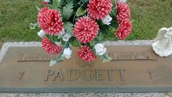
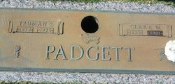
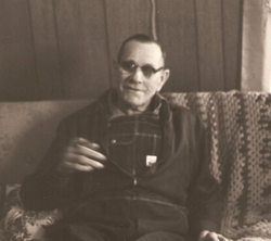
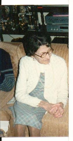
Clara Mae Wright Padgett
| Birth | : | 5 Jul 1929 Greenville County, South Carolina, USA |
| Death | : | 23 Jul 2003 Fountain Inn, Greenville County, South Carolina, USA |
| Burial | : | Kent and Sussex Cemetery and Crematorium, Royal Tunbridge Wells, Tunbridge Wells Borough, England |
| Coordinate | : | 51.1173720, 0.2740330 |
| Description | : | Clara W. Padgett Fork Shoals Published in The Greenville News 07-24-2003 Clara Mae Wright Padgett, 74, a previous resident of Country Side Village Assisted Living, and formerly of 1037 McKelvey Road of the Fork Shoals community, died Wednesday, July 23, 2003. Born in Greenville County, she was a daughter of the late Furman and Susie Kernell Wright and was a member of Cedar Falls Baptist Church. Surviving are a daughter, Debra Powell, and her husband, Tom, of Liberty; a son, David Walls, and his wife, Phyllis of Phenix City, Ala.; a brother, Joe Wright, of Greenville and a sister, Dot Meeks, of Williston. Mrs.... Read More |
frequently asked questions (FAQ):
-
Where is Clara Mae Wright Padgett's memorial?
Clara Mae Wright Padgett's memorial is located at: Kent and Sussex Cemetery and Crematorium, Royal Tunbridge Wells, Tunbridge Wells Borough, England.
-
When did Clara Mae Wright Padgett death?
Clara Mae Wright Padgett death on 23 Jul 2003 in Fountain Inn, Greenville County, South Carolina, USA
-
Where are the coordinates of the Clara Mae Wright Padgett's memorial?
Latitude: 51.1173720
Longitude: 0.2740330
Family Members:
Parent
Spouse

Siblings
Children
Flowers:


Nearby Cemetories:
1. Kent and Sussex Cemetery and Crematorium
Royal Tunbridge Wells, Tunbridge Wells Borough, England
Coordinate: 51.1173720, 0.2740330
2. Trinity Churchyard
Royal Tunbridge Wells, Tunbridge Wells Borough, England
Coordinate: 51.1328200, 0.2623600
3. St. Alban's Churchyard
Frant, Wealden District, England
Coordinate: 51.0980580, 0.2698300
4. Hanover Strict Baptist Chapel
Royal Tunbridge Wells, Tunbridge Wells Borough, England
Coordinate: 51.1356700, 0.2625100
5. Woodbury Park Cemetery
Royal Tunbridge Wells, Tunbridge Wells Borough, England
Coordinate: 51.1389847, 0.2637900
6. St John's Church
Royal Tunbridge Wells, Tunbridge Wells Borough, England
Coordinate: 51.1402330, 0.2608070
7. St. Paul's Churchyard
Rusthall, Tunbridge Wells Borough, England
Coordinate: 51.1307144, 0.2376710
8. Holy Trinity Churchyard
Eridge Green, Wealden District, England
Coordinate: 51.0989300, 0.2232190
9. Pembury Burial Ground
Pembury, Tunbridge Wells Borough, England
Coordinate: 51.1416270, 0.3229290
10. St Paul New Churchyard
Rusthall, Tunbridge Wells Borough, England
Coordinate: 51.1401520, 0.2204420
11. Southborough Cemetery
Southborough, Tunbridge Wells Borough, England
Coordinate: 51.1592860, 0.2420140
12. St Peter's New Churchyard
Pembury, Tunbridge Wells Borough, England
Coordinate: 51.1506200, 0.3269600
13. All Saints Churchyard
Langton Green, Tunbridge Wells Borough, England
Coordinate: 51.1309738, 0.2022060
14. St. Peter's Churchyard
Southborough, Tunbridge Wells Borough, England
Coordinate: 51.1626549, 0.2520690
15. St. Mary the Virgin Churchyard
Speldhurst, Tunbridge Wells Borough, England
Coordinate: 51.1510790, 0.2198230
16. Southborough War Memorial
Southborough, Tunbridge Wells Borough, England
Coordinate: 51.1639214, 0.2528920
17. Bayham Old Abbey
Lamberhurst, Tunbridge Wells Borough, England
Coordinate: 51.1032690, 0.3541800
18. St. Lawrence Churchyard
Bidborough, Tunbridge Wells Borough, England
Coordinate: 51.1666950, 0.2371870
19. Old Churchyard of St Peter
Pembury, Tunbridge Wells Borough, England
Coordinate: 51.1629330, 0.3241620
20. St John the Evangelist Churchyard
Groombridge, Wealden District, England
Coordinate: 51.1179771, 0.1854370
21. St. Luke's Churchyard
Matfield, Tunbridge Wells Borough, England
Coordinate: 51.1426588, 0.3626785
22. All Souls Churchyard
Poundsbridge, Sevenoaks District, England
Coordinate: 51.1540700, 0.1961470
23. St. Peter's Churchyard
Fordcombe, Sevenoaks District, England
Coordinate: 51.1422043, 0.1792730
24. St. Peter & St. Paul Churchyard
Wadhurst, Wealden District, England
Coordinate: 51.0626960, 0.3400690