
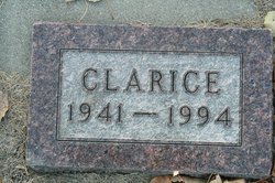
Clarice Brodshaug
| Birth | : | 15 Aug 1941 McHenry, Foster County, North Dakota, USA |
| Death | : | 18 Jan 1994 Grand Forks, Grand Forks County, North Dakota, USA |
| Burial | : | St Audry's Hospital Chapel Burial Grounds, Melton, Suffolk Coastal District, England |
| Coordinate | : | 52.1169050, 1.3321920 |
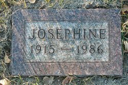
| Description | : | Brodshaug rites held at funeral home Funeral services for Clarice Brodshaug, 52, of East Grand Forks, were held January 22 at the Quam-Plaisted-Cushman Funeral Home in Cooperstown. She died January 18, 1994, in United Hospital in Grand Forks, ND. Clarice Brodshaug was born August 15, 1941, in McHenry, ND, the daughter of Clarence and Josephine (Overby) Brodshaug. She grew up and attended school in Pekin, ND. She worked on the family farm until 1986 when she moved to East Grand Forks, MN. She began working at Jeannie's Restaurant in 1989, in Grand Forks. She is survived by; one brother, Dennis Brodshaug... Read More |
frequently asked questions (FAQ):
-
Where is Clarice Brodshaug's memorial?
Clarice Brodshaug's memorial is located at: St Audry's Hospital Chapel Burial Grounds, Melton, Suffolk Coastal District, England.
-
When did Clarice Brodshaug death?
Clarice Brodshaug death on 18 Jan 1994 in Grand Forks, Grand Forks County, North Dakota, USA
-
Where are the coordinates of the Clarice Brodshaug's memorial?
Latitude: 52.1169050
Longitude: 1.3321920
Family Members:
Parent
Flowers:


Nearby Cemetories:
1. St Audry's Hospital Chapel Burial Grounds
Melton, Suffolk Coastal District, England
Coordinate: 52.1169050, 1.3321920
2. St Andrew the Apostle Churchyard
Melton, Suffolk Coastal District, England
Coordinate: 52.1065910, 1.3336210
3. Melton Old Churchyard
Melton, Suffolk Coastal District, England
Coordinate: 52.1125150, 1.3505240
4. St Andrew's Churchyard
Bredfield, Suffolk Coastal District, England
Coordinate: 52.1288710, 1.3129440
5. St Edmund's Churchyard
Bromeswell, Suffolk Coastal District, England
Coordinate: 52.1064300, 1.3617740
6. St Michael Churchyard
Boulge, Suffolk Coastal District, England
Coordinate: 52.1280920, 1.2918290
7. St. Peter and St. Paul Churchyard
Pettistree, Suffolk Coastal District, England
Coordinate: 52.1410880, 1.3525270
8. St Andrew Churchyard
Hasketon, Suffolk Coastal District, England
Coordinate: 52.1063910, 1.2845520
9. All Saints Church Burial Ground
Eyke, Suffolk Coastal District, England
Coordinate: 52.1156810, 1.3832240
10. Saint Mary Churchyard
Dallinghoo, Suffolk Coastal District, England
Coordinate: 52.1465220, 1.3109100
11. St Gregory the Great Churchyard
Rendlesham, Suffolk Coastal District, England
Coordinate: 52.1247080, 1.3952270
12. Campsey Priory
Campsey Ash, Suffolk Coastal District, England
Coordinate: 52.1396150, 1.3866000
13. All Saints Church Cemetery
Debach, Suffolk Coastal District, England
Coordinate: 52.1421030, 1.2760230
14. Charsfield Baptist Church
Charsfield, Suffolk Coastal District, England
Coordinate: 52.1590750, 1.3005590
15. St. Mary's Churchyard
Martlesham, Suffolk Coastal District, England
Coordinate: 52.0742350, 1.3000490
16. St Peter Churchyard
Charsfield, Suffolk Coastal District, England
Coordinate: 52.1614360, 1.2945540
17. Baptist Chapelyard
Grundisburgh, Suffolk Coastal District, England
Coordinate: 52.1058380, 1.2499810
18. All Saints Churchyard
Sutton, Suffolk Coastal District, England
Coordinate: 52.0682690, 1.3636990
19. St Botolph Churchyard
Burgh, Suffolk Coastal District, England
Coordinate: 52.1239800, 1.2470740
20. St. Mary's Churchyard
Great Bealings, Suffolk Coastal District, England
Coordinate: 52.0930240, 1.2554220
21. St Mary the Virgin
Grundisburgh, Suffolk Coastal District, England
Coordinate: 52.1130840, 1.2460330
22. St Mary Churchyard
Clopton, Suffolk Coastal District, England
Coordinate: 52.1269860, 1.2431221
23. St John the Baptist Churchyard
Campsey Ash, Suffolk Coastal District, England
Coordinate: 52.1520000, 1.4040000
24. All Saints Churchyard
Little Bealings, Suffolk Coastal District, England
Coordinate: 52.0854520, 1.2525230