
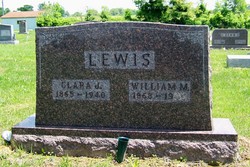
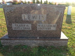
Clarissa Jane “Clara” Voyles Chastain-Lewis
| Birth | : | 8 Sep 1865 Washington County, Indiana, USA |
| Death | : | 12 Feb 1940 Washington County, Indiana, USA |
| Burial | : | St Michael Churchyard, Stragglethorpe, North Kesteven District, England |
| Coordinate | : | 53.0609600, -0.6382370 |
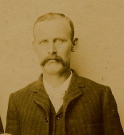
| Description | : | Clarissa Jane Voyles, daughter of David Lafayette Voyles and Elizabeth (Eliza) A. Stephenson married 09 May 1883 Washington County, Indiana, William Greene Chastain, married William M. Lewis 14 May 1913 Washington County, Indiana Indiana, Marriages, 1780-1992 groom's name: William G. Chastain bride's name: Clarissa J. Voyles marriage date: 09 May 1883 indexing project (batch) number: I00299-0 system origin: Indiana-EASy source film number: 549463 United States Census, 1900 name: Clarice J Chastain titles & terms: event: Census event date: 1900 event place: ED 139 Vernon Township, Washington, Indiana, United States birth date: Sep 1866 birthplace: Indiana relationship to head of household: Daughter father's birthplace: Indiana mother's... Read More |
frequently asked questions (FAQ):
-
Where is Clarissa Jane “Clara” Voyles Chastain-Lewis's memorial?
Clarissa Jane “Clara” Voyles Chastain-Lewis's memorial is located at: St Michael Churchyard, Stragglethorpe, North Kesteven District, England.
-
When did Clarissa Jane “Clara” Voyles Chastain-Lewis death?
Clarissa Jane “Clara” Voyles Chastain-Lewis death on 12 Feb 1940 in Washington County, Indiana, USA
-
Where are the coordinates of the Clarissa Jane “Clara” Voyles Chastain-Lewis's memorial?
Latitude: 53.0609600
Longitude: -0.6382370
Family Members:
Parent

Spouse
Siblings
Children
Flowers:


Nearby Cemetories:
1. St Michael Churchyard
Stragglethorpe, North Kesteven District, England
Coordinate: 53.0609600, -0.6382370
2. St Helen's Churchyard
Brant Broughton, North Kesteven District, England
Coordinate: 53.0744850, -0.6351690
3. St Swithun Churchyard
Leadenham, North Kesteven District, England
Coordinate: 53.0545070, -0.5835610
4. All Saints Churchyard
Fenton, South Kesteven District, England
Coordinate: 53.0462300, -0.6910100
5. St. Nicholas Churchyard
Fulbeck, South Kesteven District, England
Coordinate: 53.0426840, -0.5871030
6. All Saints Churchyard
Beckingham, North Kesteven District, England
Coordinate: 53.0740990, -0.6945420
7. St. Vincent Churchyard
Caythorpe, South Kesteven District, England
Coordinate: 53.0261420, -0.6015930
8. St Mary's Churchyard
Carlton-le-Moorland, North Kesteven District, England
Coordinate: 53.1107500, -0.6449000
9. All Saints Churchyard
Stapleford, North Kesteven District, England
Coordinate: 53.1082000, -0.6776500
10. St. Chad's Churchyard
Welbourn, North Kesteven District, England
Coordinate: 53.0790350, -0.5554450
11. All Saints Churchyard
Hough-on-the-Hill, South Kesteven District, England
Coordinate: 53.0069700, -0.6255100
12. St. Peter's Churchyard
Norton Disney, North Kesteven District, England
Coordinate: 53.1203000, -0.6717000
13. St Peter's Churchyard
Norton Disney, North Kesteven District, England
Coordinate: 53.1203200, -0.6716900
14. St Nicholas Churchyard
Normanton, South Kesteven District, England
Coordinate: 53.0051390, -0.5874570
15. St Michael's Church
Norton Disney, North Kesteven District, England
Coordinate: 53.1204000, -0.6795000
16. Newark Road Cemetery
Bassingham, North Kesteven District, England
Coordinate: 53.1265300, -0.6429400
17. St. Michael's Churchyard
Bassingham, North Kesteven District, England
Coordinate: 53.1265350, -0.6431400
18. All Saints Churchyard
Wellingore, North Kesteven District, England
Coordinate: 53.0970300, -0.5346000
19. St. Nicholas Churchyard
Carlton Scroop, South Kesteven District, England
Coordinate: 52.9940290, -0.5895960
20. All Saints Churchyard
Hougham, South Kesteven District, England
Coordinate: 52.9878240, -0.6806910
21. St. Peter's Churchyard
Navenby, North Kesteven District, England
Coordinate: 53.1087600, -0.5278700
22. St Germain Churchyard
Thurlby, South Kesteven District, England
Coordinate: 53.1447870, -0.6425330
23. St Giles Churchyard
Balderton, Newark and Sherwood District, England
Coordinate: 53.0553010, -0.7780750
24. Navenby Cemetery
Navenby, North Kesteven District, England
Coordinate: 53.1081630, -0.5208700