
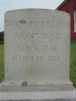
Cynthia Spilman Armstrong
| Birth | : | 3 Feb 1841 |
| Death | : | 18 Mar 1914 |
| Burial | : | St Thomas the Martyr Churchyard, Up Holland, West Lancashire District, England |
| Coordinate | : | 53.5402980, -2.7195920 |
frequently asked questions (FAQ):
-
Where is Cynthia Spilman Armstrong's memorial?
Cynthia Spilman Armstrong's memorial is located at: St Thomas the Martyr Churchyard, Up Holland, West Lancashire District, England.
-
When did Cynthia Spilman Armstrong death?
Cynthia Spilman Armstrong death on 18 Mar 1914 in
-
Where are the coordinates of the Cynthia Spilman Armstrong's memorial?
Latitude: 53.5402980
Longitude: -2.7195920
Family Members:
Parent

Siblings
Flowers:


Nearby Cemetories:
1. St Thomas the Martyr Churchyard
Up Holland, West Lancashire District, England
Coordinate: 53.5402980, -2.7195920
2. Salem Churchyard
Orrell, Metropolitan Borough of Wigan, England
Coordinate: 53.5331572, -2.7107046
3. St James Roman Catholic Churchyard
Orrell, Metropolitan Borough of Wigan, England
Coordinate: 53.5300000, -2.7140000
4. St. Joseph's College
Up Holland, West Lancashire District, England
Coordinate: 53.5525740, -2.7307890
5. St John the Divine Churchyard
Pemberton, Metropolitan Borough of Wigan, England
Coordinate: 53.5373860, -2.6823840
6. St. Matthew Churchyard
Pemberton, Metropolitan Borough of Wigan, England
Coordinate: 53.5290100, -2.6721300
7. St. Michael's Churchyard
Dalton, West Lancashire District, England
Coordinate: 53.5670360, -2.7640390
8. St. Paul's Church of England Churchyard
Wigan, Metropolitan Borough of Wigan, England
Coordinate: 53.5278761, -2.6536048
9. St. Paul's Churchyard
Skelmersdale, West Lancashire District, England
Coordinate: 53.5502050, -2.7929450
10. St Mary Roman Catholic Churchyard
Billinge, Metropolitan Borough of St Helens, England
Coordinate: 53.4909850, -2.7180090
11. Holy Trinity Churchyard
Ashton-In-Makerfield, Metropolitan Borough of Wigan, England
Coordinate: 53.4989280, -2.6688000
12. All Saints Churchyard
Wigan, Metropolitan Borough of Wigan, England
Coordinate: 53.5458134, -2.6334023
13. St Marie Churchyard
Standish, Metropolitan Borough of Wigan, England
Coordinate: 53.5844610, -2.6704070
14. Gidlow Cemetery
Standish, Metropolitan Borough of Wigan, England
Coordinate: 53.5681220, -2.6437140
15. St. Joseph's Roman Catholic Church Cemetery
Wrightington, West Lancashire District, England
Coordinate: 53.5923300, -2.7010200
16. Christ Church Churchyard
Parbold, West Lancashire District, England
Coordinate: 53.5908500, -2.7531900
17. Skelmersdale Cemetery
Skelmersdale, West Lancashire District, England
Coordinate: 53.5446820, -2.8131570
18. St. Richard's Roman Catholic Cemetery
Skelmersdale, West Lancashire District, England
Coordinate: 53.5442920, -2.8143760
19. All Saints Church
Rainford, Metropolitan Borough of St Helens, England
Coordinate: 53.5000210, -2.7870990
20. Our Lady and All Saints Roman Catholic
Parbold, West Lancashire District, England
Coordinate: 53.5911900, -2.7644350
21. St Wilfrid Churchyard
Standish, Metropolitan Borough of Wigan, England
Coordinate: 53.5868240, -2.6616530
22. Lower Ince Cemetery
Ince in Makerfield, Metropolitan Borough of Wigan, England
Coordinate: 53.5315670, -2.6209900
23. Christchurch Churchyard
Newburgh, West Lancashire District, England
Coordinate: 53.5876845, -2.7842440
24. Ince-in-Makerfield cemetery
Ince in Makerfield, Metropolitan Borough of Wigan, England
Coordinate: 53.5323940, -2.6176660