
| Birth | : | 12 Apr 1916 Chanute, Neosho County, Kansas, USA |
| Death | : | 1 Dec 2004 Independence, Montgomery County, Kansas, USA |
| Burial | : | Harrisonville Cemetery, Bolton, Montgomery County, USA |
| Coordinate | : | 37.1315100, -95.8146800 |
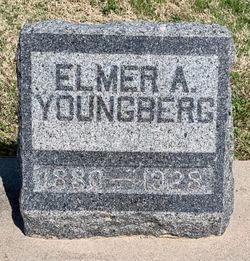
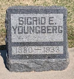
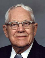
| Description | : | Dale Warner Youngberg, 88, of Independence, Kansas passed away Wednesday, December 01, 2004 at the Regal Estates of Independence, Kansas. Dale was born April 12, 1916 in Chanute, Kansas to Elmer A. and Sigrid Elvira (Warner) Youngberg. He grew up in Chanute where he attended schools and graduated from Chanute High School in 1934. He worked at the Ash Grove Cement Plant in Chanute until he entered the U. S. Army in 1942. He served in the 9th Army Artillery, Battery C 698 Field Artillery and the 265th Field Artillery in battles in France and Germany during WWII. Following his discharge... Read More |
frequently asked questions (FAQ):
-
Where is Dale Warner Youngberg's memorial?
Dale Warner Youngberg's memorial is located at: Harrisonville Cemetery, Bolton, Montgomery County, USA.
-
When did Dale Warner Youngberg death?
Dale Warner Youngberg death on 1 Dec 2004 in Independence, Montgomery County, Kansas, USA
-
Where are the coordinates of the Dale Warner Youngberg's memorial?
Latitude: 37.1315100
Longitude: -95.8146800
Family Members:
Parent
Spouse

Siblings

Flowers:


Nearby Cemetories:
1. Harrisonville Cemetery
Bolton, Montgomery County, USA
Coordinate: 37.1315100, -95.8146800
2. Jefferson Cemetery
Montgomery County, USA
Coordinate: 37.1039009, -95.7469025
3. Fawn Creek Cemetery
Tyro, Montgomery County, USA
Coordinate: 37.0667000, -95.8016968
4. Webb Cemetery
Tyro, Montgomery County, USA
Coordinate: 37.0736200, -95.8591100
5. Highland Cemetery
Montgomery County, USA
Coordinate: 37.2092018, -95.8283005
6. Pioneer Cemetery
Tyro, Montgomery County, USA
Coordinate: 37.0392500, -95.8008000
7. West Brown Cemetery
Dearing, Montgomery County, USA
Coordinate: 37.0549800, -95.7475000
8. Rutland Cemetery
Independence, Montgomery County, USA
Coordinate: 37.1963997, -95.9008026
9. Trinity Lutheran Cemetery
Tyro, Montgomery County, USA
Coordinate: 37.0266991, -95.8371964
10. Havana Cemetery
Havana, Montgomery County, USA
Coordinate: 37.0941760, -95.9417470
11. Quaker Cemetery
Elk City, Montgomery County, USA
Coordinate: 37.2395900, -95.8243400
12. Black Jack Cemetery
Caney, Montgomery County, USA
Coordinate: 37.0197000, -95.8739800
13. Robbins Cemetery
Coffeyville, Montgomery County, USA
Coordinate: 37.0339012, -95.7192001
14. Spring Hill Cemetery
Montgomery County, USA
Coordinate: 37.1235600, -95.6595500
15. Swingin' B Ranch Cemetery
Coffeyville, Montgomery County, USA
Coordinate: 37.0072900, -95.7836500
16. Parker Cemetery
Montgomery County, USA
Coordinate: 37.2630997, -95.8572006
17. Hillsdale Cemetery
Chautauqua County, USA
Coordinate: 37.1472015, -95.9841995
18. Mount Hope Cemetery
Independence, Montgomery County, USA
Coordinate: 37.2413300, -95.7060050
19. Aiken Cemetery
Chautauqua County, USA
Coordinate: 37.1796989, -95.9822006
20. Montgomery County Poor Farm Cemetery
Liberty, Montgomery County, USA
Coordinate: 37.1888590, -95.6493690
21. Sunnyside Cemetery
Caney, Montgomery County, USA
Coordinate: 37.0181007, -95.9291992
22. Calvary Cemetery
Independence, Montgomery County, USA
Coordinate: 37.2486000, -95.7043991
23. Fairview Cemetery
Coffeyville, Montgomery County, USA
Coordinate: 37.0546989, -95.6536026
24. Le Hunt Cemetery
Montgomery County, USA
Coordinate: 37.2744300, -95.7586200