
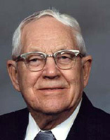


Ruel Raymond Elmer Youngberg
| Birth | : | 8 Oct 1911 Chanute, Neosho County, Kansas, USA |
| Death | : | 8 Sep 2007 Chanute, Neosho County, Kansas, USA |
| Burial | : | Saint Mary's Catholic Cemetery and Mausoleum, Sacramento, Sacramento County, USA |
| Coordinate | : | 38.5298900, -121.4261200 |
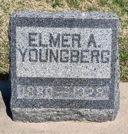
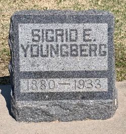
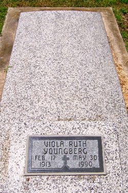
| Description | : | ************************* Chanute Tribune ~ Chanute, KS ~ September 11, 2007 Ruel R. Youngberg, 95, Chanute, Kansas, died Saturday, September 8, 2007, at the Neosho Memorial Regional Medical Center in Chanute. He was born Oct. 8, 1911, in Chanute, Kansas, to Elmer and Sigred (Warner) Youngberg. He married Viola Ruth Rensing on July 28, 1935, in Chanute, Kansas. She preceded him in death on May 30, 1990. He married Mabel Davidson on Oct. 10, 1992, at Chanute, Kansas. She survives. He was a member of St. Patrick's Catholic Church, and the Senior Citizens Group of Chanute, KS. Other survivors include two sons, Norman Youngberg, Miami,... Read More |
frequently asked questions (FAQ):
-
Where is Ruel Raymond Elmer Youngberg's memorial?
Ruel Raymond Elmer Youngberg's memorial is located at: Saint Mary's Catholic Cemetery and Mausoleum, Sacramento, Sacramento County, USA.
-
When did Ruel Raymond Elmer Youngberg death?
Ruel Raymond Elmer Youngberg death on 8 Sep 2007 in Chanute, Neosho County, Kansas, USA
-
Where are the coordinates of the Ruel Raymond Elmer Youngberg's memorial?
Latitude: 38.5298900
Longitude: -121.4261200
Family Members:
Parent
Spouse
Siblings


Children
Flowers:


Nearby Cemetories:
1. Saint Mary's Catholic Cemetery and Mausoleum
Sacramento, Sacramento County, USA
Coordinate: 38.5298900, -121.4261200
2. Sacramento County Hospital Cemetery
Sacramento, Sacramento County, USA
Coordinate: 38.5289300, -121.4239100
3. Russian Orthodox Cemetery
Sacramento, Sacramento County, USA
Coordinate: 38.5268800, -121.4244300
4. Sacramento County Cemetery
Sacramento County, USA
Coordinate: 38.5267900, -121.4233700
5. Sacramento County Veterans Memorial Cemetery
Sacramento, Sacramento County, USA
Coordinate: 38.5252838, -121.4239120
6. Tinh Xa Ngoc An Temple Columbarium
Sacramento, Sacramento County, USA
Coordinate: 38.5190200, -121.4159500
7. Sacramento Memorial Lawn Cemetery
Sacramento, Sacramento County, USA
Coordinate: 38.5146484, -121.4380341
8. Home of Peace Cemetery
Sacramento, Sacramento County, USA
Coordinate: 38.5137558, -121.4382782
9. Elder Creek Cemetery
Florin, Sacramento County, USA
Coordinate: 38.5111008, -121.4169006
10. Saint Rose Cemetery (Defunct)
Sacramento, Sacramento County, USA
Coordinate: 38.5208015, -121.4672012
11. East Lawn Memorial Park
Sacramento, Sacramento County, USA
Coordinate: 38.5612960, -121.4492760
12. Pho Minh Temple Columbarium
Sacramento, Sacramento County, USA
Coordinate: 38.5340100, -121.4769000
13. New Helvetia Cemetery (Defunct)
Sacramento, Sacramento County, USA
Coordinate: 38.5731600, -121.4639900
14. Saint Joseph Cemetery
Sacramento, Sacramento County, USA
Coordinate: 38.5574989, -121.4835968
15. Trinity Episcopal Cathedral Columbarium
Sacramento, Sacramento County, USA
Coordinate: 38.5705500, -121.4723770
16. Odd Fellows Lawn Cemetery and Mausoleum
Sacramento, Sacramento County, USA
Coordinate: 38.5585000, -121.5011000
17. Buddhist Church of Sacramento Nokotsudo
Sacramento, Sacramento County, USA
Coordinate: 38.5639300, -121.4978400
18. Sacramento City Cemetery
Sacramento, Sacramento County, USA
Coordinate: 38.5636864, -121.5009537
19. Masonic Lawn Cemetery
Sacramento, Sacramento County, USA
Coordinate: 38.5604720, -121.5032600
20. Sunset Hill Cemetery
Sacramento, Sacramento County, USA
Coordinate: 38.5608000, -121.5037300
21. California State Capitol
Sacramento, Sacramento County, USA
Coordinate: 38.5760994, -121.4931488
22. National Shrine of Our Lady of Guadalupe Crypt
Sacramento, Sacramento County, USA
Coordinate: 38.5704800, -121.5014400
23. Kim Quang Temple Columbarium
Sacramento, Sacramento County, USA
Coordinate: 38.5996600, -121.3904700
24. Holy Ascension Russian Orthodox Cemetery
Sacramento, Sacramento County, USA
Coordinate: 38.5846212, -121.4936736