
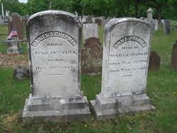
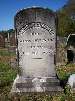
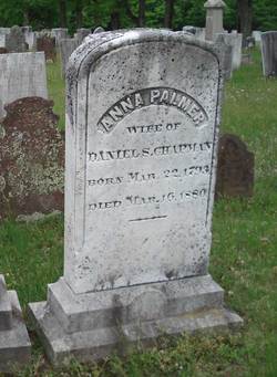
Daniel S Chapman
| Birth | : | 18 Jul 1794 |
| Death | : | 26 Oct 1877 |
| Burial | : | St Mary Churchyard, Warthill, Ryedale District, England |
| Coordinate | : | 53.9887610, -0.9714450 |
frequently asked questions (FAQ):
-
Where is Daniel S Chapman's memorial?
Daniel S Chapman's memorial is located at: St Mary Churchyard, Warthill, Ryedale District, England.
-
When did Daniel S Chapman death?
Daniel S Chapman death on 26 Oct 1877 in
-
Where are the coordinates of the Daniel S Chapman's memorial?
Latitude: 53.9887610
Longitude: -0.9714450
Family Members:
Parent
Spouse
Siblings

Flowers:


Nearby Cemetories:
1. St Mary Churchyard
Warthill, Ryedale District, England
Coordinate: 53.9887610, -0.9714450
2. Holy Trinity Churchyard
Holtby, York Unitary Authority, England
Coordinate: 53.9792890, -0.9719310
3. St. Mary's Churchyard
Gate Helmsley, Ryedale District, England
Coordinate: 53.9883720, -0.9481980
4. St Peter Churchyard
Stockton-on-the-Forest, York Unitary Authority, England
Coordinate: 53.9964440, -0.9991290
5. Holy Trinity Churchyard
Stockton-on-the-Forest, York Unitary Authority, England
Coordinate: 53.9960220, -0.9994630
6. Dunnington Cemetery
Dunnington, York Unitary Authority, England
Coordinate: 53.9675110, -0.9823760
7. St Nicholas Churchyard
Dunnington, York Unitary Authority, England
Coordinate: 53.9661680, -0.9829590
8. St Peter Churchyard
Upper Helmsley, Ryedale District, England
Coordinate: 54.0044650, -0.9409770
9. All Saints Churchyard
Low Catton, East Riding of Yorkshire Unitary Authority, England
Coordinate: 53.9769280, -0.9268720
10. Saint James Churchyard
Murton, York Unitary Authority, England
Coordinate: 53.9656390, -1.0125031
11. St. Mary's Churchyard
Sand Hutton, Ryedale District, England
Coordinate: 54.0183800, -0.9410700
12. St Paul Churchyard
Kexby, York Unitary Authority, England
Coordinate: 53.9505970, -0.9339900
13. St Thomas Churchyard
Osbaldwick, York Unitary Authority, England
Coordinate: 53.9588640, -1.0338800
14. New Lane Cemetery
Huntington, York Unitary Authority, England
Coordinate: 53.9816223, -1.0576156
15. All Saints Churchyard
Huntington, York Unitary Authority, England
Coordinate: 53.9977460, -1.0633490
16. Holy Trinity Churchyard
Heworth, York Unitary Authority, England
Coordinate: 53.9660080, -1.0596980
17. St John the Evangelist Churchyard
Buttercrambe, Ryedale District, England
Coordinate: 54.0137300, -0.8812900
18. St Paul Churchyard
Heslington, York Unitary Authority, England
Coordinate: 53.9471780, -1.0445150
19. St Lawrence Churchyard
Flaxton, Ryedale District, England
Coordinate: 54.0508680, -0.9624500
20. St Botolph Churchyard
Bossall, Ryedale District, England
Coordinate: 54.0375570, -0.9047540
21. St Mary the Virgin Churchyard
Strensall, York Unitary Authority, England
Coordinate: 54.0389130, -1.0394910
22. St Mary Churchyard
Full Sutton, East Riding of Yorkshire Unitary Authority, England
Coordinate: 53.9897620, -0.8613700
23. St Edward's-without-Walmgate (Defunct)
York, York Unitary Authority, England
Coordinate: 53.9547280, -1.0657383
24. St. Lawrence's Churchyard
York, York Unitary Authority, England
Coordinate: 53.9540530, -1.0688730