
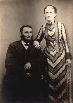
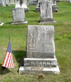


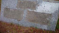
David C Stark
| Birth | : | 31 Jul 1839 Lyme, Grafton County, New Hampshire, USA |
| Death | : | 23 Dec 1905 Lyme, Grafton County, New Hampshire, USA |
| Burial | : | St Peter and St Paul Churchyard, Scrayingham, Ryedale District, England |
| Coordinate | : | 54.0342510, -0.8826130 |
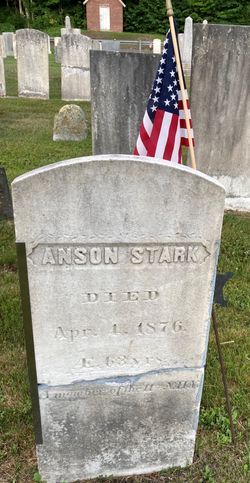
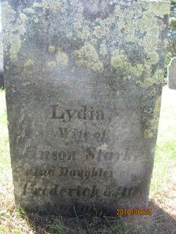
| Description | : | David was the son of Anson Stark and Lydia Dodge. He married Mary Ann Runnals 19 March 1861 in Lyme, NH. They had nine children: Frank, Jennie, Ida, Olivia, Elsie, Harlan, Francis, Alden, and Ernest. David served as Corporal in Co H, 11th Reg NH Inf. Vol commanded by Capt Joseph Clark. On May 12, 1864 he was wounded in the head and wrist at Spottsylvania, Chestnut Hill, VA. He was honorably discharged on June 4, 1865. |
frequently asked questions (FAQ):
-
Where is David C Stark's memorial?
David C Stark's memorial is located at: St Peter and St Paul Churchyard, Scrayingham, Ryedale District, England.
-
When did David C Stark death?
David C Stark death on 23 Dec 1905 in Lyme, Grafton County, New Hampshire, USA
-
Where are the coordinates of the David C Stark's memorial?
Latitude: 54.0342510
Longitude: -0.8826130
Family Members:
Parent
Spouse
Siblings
Children
Flowers:


Nearby Cemetories:
1. St Peter and St Paul Churchyard
Scrayingham, Ryedale District, England
Coordinate: 54.0342510, -0.8826130
2. St Botolph Churchyard
Bossall, Ryedale District, England
Coordinate: 54.0375570, -0.9047540
3. St John the Evangelist Churchyard
Buttercrambe, Ryedale District, England
Coordinate: 54.0137300, -0.8812900
4. Howsham Churchyard
Howsham, Ryedale District, England
Coordinate: 54.0565520, -0.8755670
5. St. Mary's Churchyard
Sand Hutton, Ryedale District, England
Coordinate: 54.0183800, -0.9410700
6. St Michael Churchyard
Crambe, Ryedale District, England
Coordinate: 54.0744550, -0.8809390
7. St Andrew Churchyard
Bugthorpe, East Riding of Yorkshire Unitary Authority, England
Coordinate: 54.0108100, -0.8226900
8. St Peter Churchyard
Upper Helmsley, Ryedale District, England
Coordinate: 54.0044650, -0.9409770
9. St Mary Churchyard
Full Sutton, East Riding of Yorkshire Unitary Authority, England
Coordinate: 53.9897620, -0.8613700
10. Kirkham Priory
Kirkham, Ryedale District, England
Coordinate: 54.0826180, -0.8768470
11. St John the Baptist
Acklam, Ryedale District, England
Coordinate: 54.0451010, -0.8006330
12. St Lawrence Churchyard
Flaxton, Ryedale District, England
Coordinate: 54.0508680, -0.9624500
13. All Saints Churchyard
Foston, Ryedale District, England
Coordinate: 54.0775719, -0.9331510
14. St. Mary's Churchyard
Westow, Ryedale District, England
Coordinate: 54.0846190, -0.8406850
15. St. Mary's Churchyard
Gate Helmsley, Ryedale District, England
Coordinate: 53.9883720, -0.9481980
16. All Saints Churchyard
Low Catton, East Riding of Yorkshire Unitary Authority, England
Coordinate: 53.9769280, -0.9268720
17. Burythorpe Churchyard
Burythorpe, Ryedale District, England
Coordinate: 54.0752951, -0.7955984
18. St John the Evangelist Churchyard
Welburn (Malton), Ryedale District, England
Coordinate: 54.1008850, -0.8985440
19. St Mary Churchyard
Warthill, Ryedale District, England
Coordinate: 53.9887610, -0.9714450
20. All Saints Churchyard
Kirby Underdale, East Riding of Yorkshire Unitary Authority, England
Coordinate: 54.0166200, -0.7677100
21. St Martin Churchyard
Fangfoss, East Riding of Yorkshire Unitary Authority, England
Coordinate: 53.9704970, -0.8324690
22. St Martin Churchyard
Bulmer, Ryedale District, England
Coordinate: 54.0997510, -0.9317700
23. St. Margaret's Churchyard
Huttons Ambo, Ryedale District, England
Coordinate: 54.1066490, -0.8490640
24. St. Edith Churchyard
Bishop Wilton, East Riding of Yorkshire Unitary Authority, England
Coordinate: 53.9862300, -0.7838500