

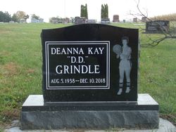
Deanna Kay “D.D.” Grindle
| Birth | : | 5 Aug 1938 Strahan, Mills County, Iowa, USA |
| Death | : | 10 Dec 2018 Stanton, Montgomery County, Iowa, USA |
| Burial | : | Wesley Chapel Cemetery, Henderson, Mills County, USA |
| Coordinate | : | 41.1019249, -95.4987793 |
| Description | : | Deanna Grindle, 80, of Red Oak, IA, passed away December 10, 2018 at the Accura Health Care in Stanton, IA. Funeral services will be held at 10:00 a.m. on Saturday, December 15, 2018 at the Loess Hills Funeral Home in Malvern. Burial will be in the Wesley Chapel Cemetery, rural Hastings. Visitation will be held one hour prior to the service at the funeral home. Memorials: Nebraska Humane Society or Strahan United Methodist Church Deanna Kay Grindle, one of three children of Ellis G. and Ethel M. (Wright) Grindle, was born on August 5, 1938 at Strahan, Iowa. She attended... Read More |
frequently asked questions (FAQ):
-
Where is Deanna Kay “D.D.” Grindle's memorial?
Deanna Kay “D.D.” Grindle's memorial is located at: Wesley Chapel Cemetery, Henderson, Mills County, USA.
-
When did Deanna Kay “D.D.” Grindle death?
Deanna Kay “D.D.” Grindle death on 10 Dec 2018 in Stanton, Montgomery County, Iowa, USA
-
Where are the coordinates of the Deanna Kay “D.D.” Grindle's memorial?
Latitude: 41.1019249
Longitude: -95.4987793
Family Members:
Parent

Siblings

Flowers:


Nearby Cemetories:
1. Wesley Chapel Cemetery
Henderson, Mills County, USA
Coordinate: 41.1019249, -95.4987793
2. Saylers Farm Cemetery
Henderson, Mills County, USA
Coordinate: 41.1083300, -95.4919440
3. Cotten Cemetery
Mills County, USA
Coordinate: 41.0845000, -95.5167000
4. Wearin Cemetery
Malvern, Mills County, USA
Coordinate: 41.0395000, -95.5313000
5. Farm Creek Cemetery
Henderson, Mills County, USA
Coordinate: 41.1319008, -95.4186020
6. East Liberty Cemetery
Malvern, Mills County, USA
Coordinate: 41.0592346, -95.6005020
7. North Grove Cemetery
Hastings, Mills County, USA
Coordinate: 41.0161018, -95.4618988
8. Hastings Cemetery
Hastings, Mills County, USA
Coordinate: 41.0097008, -95.4993973
9. Emerson Cemetery
Emerson, Mills County, USA
Coordinate: 41.0325012, -95.4021988
10. Lowens Cemetery
Garfield Township, Montgomery County, USA
Coordinate: 41.0527728, -95.3758292
11. Silver City Cemetery
Silver City, Mills County, USA
Coordinate: 41.1042442, -95.6380005
12. Macedonia Cemetery
Macedonia, Pottawattamie County, USA
Coordinate: 41.1921997, -95.4167023
13. Old Town Cemetery
Macedonia, Pottawattamie County, USA
Coordinate: 41.2030983, -95.4421997
14. South Grove Cemetery
Mills County, USA
Coordinate: 40.9775009, -95.4931030
15. Malvern Cemetery
Malvern, Mills County, USA
Coordinate: 40.9886017, -95.5785980
16. Parker Cemetery
White Cloud, Mills County, USA
Coordinate: 40.9737649, -95.5184363
17. Buckner Cemetery
Wales, Montgomery County, USA
Coordinate: 41.1595600, -95.3440700
18. Mormon Cemetery
Macedonia, Pottawattamie County, USA
Coordinate: 41.1885986, -95.3557663
19. Hillsdale Cemetery
Glenwood, Mills County, USA
Coordinate: 41.0097008, -95.6427994
20. Gomer Cemetery
Wales, Montgomery County, USA
Coordinate: 41.1171989, -95.3082962
21. Mills County Farm Cemetery
Glenwood, Mills County, USA
Coordinate: 41.0417930, -95.6756530
22. Mineola Cemetery
Mineola, Mills County, USA
Coordinate: 41.1391130, -95.6941800
23. Zion Congregational Cemetery
Treynor, Pottawattamie County, USA
Coordinate: 41.2325090, -95.6079200
24. Carson Cemetery
Carson, Pottawattamie County, USA
Coordinate: 41.2392006, -95.4044037