
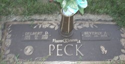
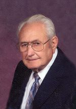
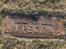
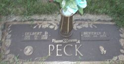
Delbert Dwane “Dutch” Peck
| Birth | : | 22 Jan 1930 Huron, Beadle County, South Dakota, USA |
| Death | : | 11 Oct 2007 Huron, Beadle County, South Dakota, USA |
| Burial | : | Sunset Lawn Chapel of the Chimes Memorial Park, Sacramento, Sacramento County, USA |
| Coordinate | : | 38.6514816, -121.4384842 |
| Description | : | Researched and compiled by the Kartchner Brothers Delbert Dwane "Dutch" Peck, age 77, of Huron, died Thursday, October 11, 2007, at the Huron Nursing Home. Delbert Dwane Peck was born on January 22, 1930, to Irven and Anne (Haffner) Peck in Huron. He attended schools in Huron. Following his formal education he worked with his father as a carpenter. On AUgust 31, 1951, Delbert entered the U.S. Marine Corps, serving 13 months on the frontlines in the Korean War. He was honorably discharged on August 30, 1953. On April 10, 1953, Delbert... Read More |
frequently asked questions (FAQ):
-
Where is Delbert Dwane “Dutch” Peck's memorial?
Delbert Dwane “Dutch” Peck's memorial is located at: Sunset Lawn Chapel of the Chimes Memorial Park, Sacramento, Sacramento County, USA.
-
When did Delbert Dwane “Dutch” Peck death?
Delbert Dwane “Dutch” Peck death on 11 Oct 2007 in Huron, Beadle County, South Dakota, USA
-
Where are the coordinates of the Delbert Dwane “Dutch” Peck's memorial?
Latitude: 38.6514816
Longitude: -121.4384842
Family Members:
Parent

Spouse
Siblings
Children
Flowers:


Nearby Cemetories:
1. Kim Quang Temple Columbarium
Sacramento, Sacramento County, USA
Coordinate: 38.5996600, -121.3904700
2. Saint Marks Methodist Church Memorial Tree
Sacramento, Sacramento County, USA
Coordinate: 38.6076500, -121.3750680
3. Holy Ascension Russian Orthodox Cemetery
Sacramento, Sacramento County, USA
Coordinate: 38.5846212, -121.4936736
4. Saint Michaels Episcopal Church Columbarium
Carmichael, Sacramento County, USA
Coordinate: 38.6042800, -121.3547200
5. New Helvetia Cemetery (Defunct)
Sacramento, Sacramento County, USA
Coordinate: 38.5731600, -121.4639900
6. Trinity Episcopal Cathedral Columbarium
Sacramento, Sacramento County, USA
Coordinate: 38.5705500, -121.4723770
7. Union Cemetery
Roseville, Placer County, USA
Coordinate: 38.7302600, -121.3924200
8. California State Capitol
Sacramento, Sacramento County, USA
Coordinate: 38.5760994, -121.4931488
9. Carmichael Presbyterian Church Columbarium
Carmichael, Sacramento County, USA
Coordinate: 38.6179500, -121.3324500
10. East Lawn Memorial Park
Sacramento, Sacramento County, USA
Coordinate: 38.5612960, -121.4492760
11. Sierra Hills Pet Cemetery
Sacramento, Sacramento County, USA
Coordinate: 38.6863500, -121.3305300
12. Sierra Hills Memorial Park
Sacramento, Sacramento County, USA
Coordinate: 38.6843987, -121.3281021
13. National Shrine of Our Lady of Guadalupe Crypt
Sacramento, Sacramento County, USA
Coordinate: 38.5704800, -121.5014400
14. Buddhist Church of Sacramento Nokotsudo
Sacramento, Sacramento County, USA
Coordinate: 38.5639300, -121.4978400
15. Calvary Catholic Cemetery and Mausoleum
Sacramento, Sacramento County, USA
Coordinate: 38.6937180, -121.3233109
16. Saint Joseph Cemetery
Sacramento, Sacramento County, USA
Coordinate: 38.5574989, -121.4835968
17. Sacramento City Cemetery
Sacramento, Sacramento County, USA
Coordinate: 38.5636864, -121.5009537
18. Sunset Hill Cemetery
Sacramento, Sacramento County, USA
Coordinate: 38.5608000, -121.5037300
19. Masonic Lawn Cemetery
Sacramento, Sacramento County, USA
Coordinate: 38.5604720, -121.5032600
20. Odd Fellows Lawn Cemetery and Mausoleum
Sacramento, Sacramento County, USA
Coordinate: 38.5585000, -121.5011000
21. Pho Minh Temple Columbarium
Sacramento, Sacramento County, USA
Coordinate: 38.5340100, -121.4769000
22. Saint Mary's Catholic Cemetery and Mausoleum
Sacramento, Sacramento County, USA
Coordinate: 38.5298900, -121.4261200
23. Sacramento County Hospital Cemetery
Sacramento, Sacramento County, USA
Coordinate: 38.5289300, -121.4239100
24. Fair Oaks Cemetery
Fair Oaks, Sacramento County, USA
Coordinate: 38.6501167, -121.2792000