
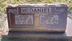
Delilah A. Ballard McDaniel
| Birth | : | 29 Oct 1881 Jewell County, Kansas, USA |
| Death | : | 20 Apr 1959 Columbus, Platte County, Nebraska, USA |
| Burial | : | Shepshed Cemetery, Shepshed, Charnwood Borough, England |
| Coordinate | : | 52.7640470, -1.2963120 |
| Description | : | From the web site: http://rootsweb.ancestry.com/~neplatte/vitals/vitals1959.html The Columbus Daily Telegram, April 21, 1959 DIED McDANIEL--Mrs. F. A. McDaniel dies; funeral service is Thursday Mrs. Floyd A. McDaniel, 77, Columbus, died Monday night at St. Mary's hospital. Funeral services will be held at 2 p.m. Thursday at the Evangelical Free church, with the Rev. Earl T. Gunsolley officiating, and burial will be in the Columbus Cemetery. The body will lie in state at the Gass Funeral home from 11 a.m. Wednesday until the hour of service. As Delilah Ann Ballard, she was born... Read More |
frequently asked questions (FAQ):
-
Where is Delilah A. Ballard McDaniel's memorial?
Delilah A. Ballard McDaniel's memorial is located at: Shepshed Cemetery, Shepshed, Charnwood Borough, England.
-
When did Delilah A. Ballard McDaniel death?
Delilah A. Ballard McDaniel death on 20 Apr 1959 in Columbus, Platte County, Nebraska, USA
-
Where are the coordinates of the Delilah A. Ballard McDaniel's memorial?
Latitude: 52.7640470
Longitude: -1.2963120
Family Members:
Parent
Spouse

Siblings
Children
Flowers:


Nearby Cemetories:
1. Shepshed Cemetery
Shepshed, Charnwood Borough, England
Coordinate: 52.7640470, -1.2963120
2. St. Botolph’s Churchyard
Shepshed, Charnwood Borough, England
Coordinate: 52.7726830, -1.2885670
3. St. James the Greater Oaks in Charnwood
Whitwick, North West Leicestershire District, England
Coordinate: 52.7425430, -1.3008590
4. Mount St Bernard Abbey
Whitwick, North West Leicestershire District, England
Coordinate: 52.7413880, -1.3234470
5. St John Churchyard
Belton, North West Leicestershire District, England
Coordinate: 52.7830810, -1.3374590
6. Grace-Dieu Priory
Thringstone, North West Leicestershire District, England
Coordinate: 52.7609720, -1.3566830
7. All Saints Churchyard
Thorpe Acre, Charnwood Borough, England
Coordinate: 52.7750466, -1.2361551
8. All Saints' Church Dishley
Hathern, Charnwood Borough, England
Coordinate: 52.7860705, -1.2412000
9. St Mary the Blessed Virgin Church
Osgathorpe, North West Leicestershire District, England
Coordinate: 52.7715890, -1.3623270
10. St. Peters & St. Paul Cemetery
Hathern, Charnwood Borough, England
Coordinate: 52.7970560, -1.2558040
11. All Saints Churchyard
Long Whatton, North West Leicestershire District, England
Coordinate: 52.8052840, -1.2859690
12. Greenhill Rise Cemetery
Hathern, Charnwood Borough, England
Coordinate: 52.7990180, -1.2576160
13. St John the Baptist Churchyard
Whitwick, North West Leicestershire District, England
Coordinate: 52.7416040, -1.3571200
14. St. Andrew's Churchyard
Thringstone, North West Leicestershire District, England
Coordinate: 52.7529090, -1.3692140
15. Broomleys Cemetery
Coalville, North West Leicestershire District, England
Coordinate: 52.7255540, -1.3402280
16. Whitwick Cemetery
Whitwick, North West Leicestershire District, England
Coordinate: 52.7395560, -1.3623360
17. Emmanuel Churchyard
Loughborough, Charnwood Borough, England
Coordinate: 52.7668830, -1.2108020
18. St George Churchyard
Swannington, North West Leicestershire District, England
Coordinate: 52.7530997, -1.3865110
19. St Michael & All Angels Churchyard
Long Whatton, North West Leicestershire District, England
Coordinate: 52.8164170, -1.3282730
20. Methodist Church Churchyard
Griffydam, North West Leicestershire District, England
Coordinate: 52.7629060, -1.3894370
21. All Saints with Holy Trinity Churchyard
Loughborough, Charnwood Borough, England
Coordinate: 52.7743880, -1.2035500
22. St Mary's Priory
Ulverscroft, Charnwood Borough, England
Coordinate: 52.7098890, -1.2598610
23. London Road Cemetery
Coalville, North West Leicestershire District, England
Coordinate: 52.7222620, -1.3647710
24. Christ Church
Coalville, North West Leicestershire District, England
Coordinate: 52.7229610, -1.3673630