Delvora Hanna Howard
| Birth | : | 24 Apr 1913 Williamsburg County, South Carolina, USA |
| Death | : | 30 Apr 1997 Georgetown County, South Carolina, USA |
| Burial | : | Clementsville Cemetery, Clementsville, Clay County, USA |
| Coordinate | : | 36.6132300, -85.7146410 |
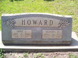
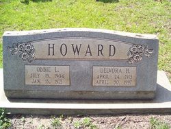
| Inscription | : | Howard Obbie L July 19 1904 Jan 15 1975 Delvora H April 24 1913 April 30 1997 |
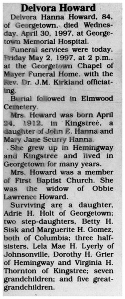
| Description | : | Delvora H. Howard GEORGETOWN -- Delvora Hanna Howard, 84, died Wednesday, April 30, 1997, at Georgetown Memorial Hospital. She was born April 24, 1913, in Kingstree, a daughter of John and Mary Jane Scurry Hanna. She was the widow of Obbie Howard. She grew up in Hemingway and Kingstree and lived in Georgetown for several years. Mrs. Howard was a member of First Baptist Church. Survivors include a daughter, Adrie Holt of Georgetown; two stepdaughters, Betty Sisk and Marguerite Gomez, both of Columbia; three half sisters, Lela Mae Lyerly of Johnsonville, Dorothy Grier of Hemingway, and Virginia Thornton of Kingstree; seven grandchildren; and five great-grandchildren. The funeral... Read More |
frequently asked questions (FAQ):
-
Where is Delvora Hanna Howard's memorial?
Delvora Hanna Howard's memorial is located at: Clementsville Cemetery, Clementsville, Clay County, USA.
-
When did Delvora Hanna Howard death?
Delvora Hanna Howard death on 30 Apr 1997 in Georgetown County, South Carolina, USA
-
Where are the coordinates of the Delvora Hanna Howard's memorial?
Latitude: 36.6132300
Longitude: -85.7146410
Family Members:
Parent
Spouse
Siblings
Flowers:
Nearby Cemetories:
1. Clementsville Cemetery
Clementsville, Clay County, USA
Coordinate: 36.6132300, -85.7146410
2. Cherry Cemetery #3
Oak Grove, Clay County, USA
Coordinate: 36.6015000, -85.7100300
3. Old Bowman Cemetery
Gamaliel, Monroe County, USA
Coordinate: 36.6289830, -85.7204190
4. Pitcock Cemetery
Clay County, USA
Coordinate: 36.5992012, -85.6911011
5. Beautiful Home Cemetery
Tompkinsville, Monroe County, USA
Coordinate: 36.6392000, -85.7371000
6. Beech Grove Cemetery
Harlan Crossroads, Monroe County, USA
Coordinate: 36.6319000, -85.6809000
7. Hinson Cemetery
Moss, Clay County, USA
Coordinate: 36.5756750, -85.7020010
8. Harlan's Crossroads Cemetery
Harlan Crossroads, Monroe County, USA
Coordinate: 36.6518500, -85.7064700
9. Moore Cemetery #1
Moss, Clay County, USA
Coordinate: 36.6164920, -85.6636620
10. Compton Cemetery
Gamaliel, Monroe County, USA
Coordinate: 36.6262040, -85.7680120
11. Carnahan Cemetery
Harlan Crossroads, Monroe County, USA
Coordinate: 36.6592700, -85.7224900
12. Liberty Church Cemetery
Boles, Clay County, USA
Coordinate: 36.6010850, -85.6496830
13. Old Bob Wood Place Cemetery
Boles, Monroe County, USA
Coordinate: 36.6325120, -85.6515600
14. Jonestown Cemetery
Clay County, USA
Coordinate: 36.5619011, -85.6921997
15. Chimney Rock Cemetery
Hermitage Springs, Clay County, USA
Coordinate: 36.6138200, -85.7849000
16. Willhoite-Curtis Cemetery
Tompkinsville, Monroe County, USA
Coordinate: 36.6182208, -85.6442948
17. Hermitage Springs Cemetery
Hermitage Springs, Clay County, USA
Coordinate: 36.5823500, -85.7750900
18. Moore Cemetery
Moss, Clay County, USA
Coordinate: 36.6113400, -85.6374980
19. Smith Cemetery
Pine Hill, Clay County, USA
Coordinate: 36.5714930, -85.6568170
20. Biles Cemetery
Hermitage Springs, Clay County, USA
Coordinate: 36.6039009, -85.7919006
21. Cherry Denton Cemetery
Clay County, USA
Coordinate: 36.5512200, -85.6971200
22. Hammer Cemetery
Tompkinsville, Monroe County, USA
Coordinate: 36.6641998, -85.6658020
23. Old Mulkey Church Cemetery
Tompkinsville, Monroe County, USA
Coordinate: 36.6778950, -85.7071430
24. Hale Cemetery
Tompkinsville, Monroe County, USA
Coordinate: 36.6753950, -85.7417460


