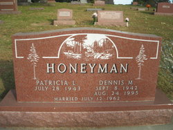
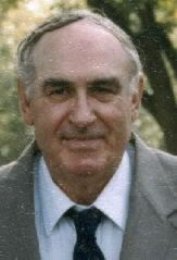
Dennis M. Honeyman
| Birth | : | 8 Sep 1942 Emerson, Mills County, Iowa, USA |
| Death | : | 24 Aug 1995 Omaha, Douglas County, Nebraska, USA |
| Burial | : | Saint Thomas the Martyr Churchyard, Oxford, City of Oxford, England |
| Coordinate | : | 51.7512222, -1.2679445 |
| Plot | : | 2nd Addition, Lot 157 |
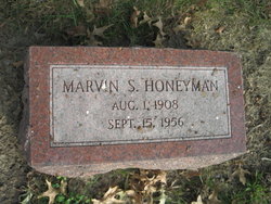
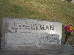
| Description | : | Dennis, son of Marvin and Dorothy Steiner Honeyman, was born September 8, 1942 at Red Oak and passed away at his home in Omaha on August 24, 1995, after a long illness. He was preceded in death by his father, Marvin and a brother Gary. His survivors include wife, Patricia L. son and daughter-in-law Mark and Ami; daughter, Lisa Lynn; son, Troy; granddaughter, Mercedes, all of Omaha; mother, Dorothy Honeyman Moninger of Red Oak; and brother Steiner, of Council Bluffs, Iowa. He was the owner of Honeyman Rent-All for 27 years. Glenwood Opinion Tribune, September 13, 1995, page 11 |
frequently asked questions (FAQ):
-
Where is Dennis M. Honeyman's memorial?
Dennis M. Honeyman's memorial is located at: Saint Thomas the Martyr Churchyard, Oxford, City of Oxford, England.
-
When did Dennis M. Honeyman death?
Dennis M. Honeyman death on 24 Aug 1995 in Omaha, Douglas County, Nebraska, USA
-
Where are the coordinates of the Dennis M. Honeyman's memorial?
Latitude: 51.7512222
Longitude: -1.2679445
Family Members:
Parent
Spouse
Siblings
Flowers:
Nearby Cemetories:
1. Saint Thomas the Martyr Churchyard
Oxford, City of Oxford, England
Coordinate: 51.7512222, -1.2679445
2. St Thomas the Martyr
Oxford, City of Oxford, England
Coordinate: 51.7518100, -1.2683430
3. Osney Cemetery
Oxford, City of Oxford, England
Coordinate: 51.7505310, -1.2703040
4. Osney Cathedral
Oxford, City of Oxford, England
Coordinate: 51.7497220, -1.2700000
5. Oxford Castle and Prison Cemetery
Oxford, City of Oxford, England
Coordinate: 51.7521453, -1.2631165
6. Rewley Abbey
Oxford, City of Oxford, England
Coordinate: 51.7543810, -1.2675170
7. St Frideswide Churchyard
Oxford, City of Oxford, England
Coordinate: 51.7521560, -1.2748350
8. Saint Peter le Bailey Churchyard
Oxford, City of Oxford, England
Coordinate: 51.7516980, -1.2600300
9. St Ebbe Churchyard
Oxford, City of Oxford, England
Coordinate: 51.7504200, -1.2596030
10. St Martin's Church, Carfax (Defunct)
Oxford, City of Oxford, England
Coordinate: 51.7513500, -1.2581700
11. St. Michael at the North Gate Church
Oxford, City of Oxford, England
Coordinate: 51.7537210, -1.2583950
12. St. Mary Magdalene's Churchyard
Oxford, City of Oxford, England
Coordinate: 51.7546250, -1.2588340
13. Martyrs' Memorial
Oxford, City of Oxford, England
Coordinate: 51.7550900, -1.2590100
14. Saint Barnabas Church
Oxford, City of Oxford, England
Coordinate: 51.7579620, -1.2697600
15. Blackfriars
Oxford, City of Oxford, England
Coordinate: 51.7561210, -1.2602060
16. St Johns College
Oxford, City of Oxford, England
Coordinate: 51.7560820, -1.2589910
17. Jesus College Chapel
Oxford, City of Oxford, England
Coordinate: 51.7536130, -1.2566180
18. Balliol College Chapel
Oxford, City of Oxford, England
Coordinate: 51.7547800, -1.2572240
19. University Church of St Mary the Virgin
Oxford, City of Oxford, England
Coordinate: 51.7523990, -1.2556000
20. All Saints Churchyard
Oxford, City of Oxford, England
Coordinate: 51.7525000, -1.2555560
21. Exeter College Chapel
Oxford, City of Oxford, England
Coordinate: 51.7539460, -1.2561170
22. Trinity College Chapel
Oxford, City of Oxford, England
Coordinate: 51.7552360, -1.2569620
23. Christ Church Cathedral
Oxford, City of Oxford, England
Coordinate: 51.7500620, -1.2547160
24. St Paul's Oxford Cemetery
Oxford, City of Oxford, England
Coordinate: 51.7594590, -1.2648470


