
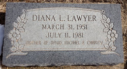
Diana L Chaput Lawyer
| Birth | : | 31 Mar 1951 Concordia, Cloud County, Kansas, USA |
| Death | : | 11 Jul 1981 Pettis County, Missouri, USA |
| Burial | : | Mount Hope Cemetery, Clyde, Cloud County, USA |
| Coordinate | : | 39.5969009, -97.4116974 |
| Plot | : | 13-7A |
| Description | : | Salina Journal Tuesday July 14, 1981 MRS. JOHN LAWYER CLYDE — The funeral for Mrs. Diana Lawyer, 30, Smithton, Mo., formerly of Clyde, will be at 10 a.m. Wednesday at the Chaput Mortuary, Clyde, the Rev. C. Milton Lenz officiating. Burial will be in Mt. Hope Cemetery, Clyde. Mrs. Lawyer died July 11 en route to a Sedalia, Mo., hospital. She was born March 31, 1951, at Concordia. She lived at Clyde and later at Sedalia. She moved to Smithton July 1. Surviving are her husband, John D.; two sons, David and Michael, and a daughter, Charity Ann, all of the home; her... Read More |
frequently asked questions (FAQ):
-
Where is Diana L Chaput Lawyer's memorial?
Diana L Chaput Lawyer's memorial is located at: Mount Hope Cemetery, Clyde, Cloud County, USA.
-
When did Diana L Chaput Lawyer death?
Diana L Chaput Lawyer death on 11 Jul 1981 in Pettis County, Missouri, USA
-
Where are the coordinates of the Diana L Chaput Lawyer's memorial?
Latitude: 39.5969009
Longitude: -97.4116974
Family Members:
Parent
Children
Flowers:


Nearby Cemetories:
1. Mount Calvary Cemetery
Clyde, Cloud County, USA
Coordinate: 39.5917015, -97.4143982
2. Cedar Grove Cemetery
Clyde, Cloud County, USA
Coordinate: 39.5494003, -97.4056015
3. Pleasant View Cemetery
Ames, Cloud County, USA
Coordinate: 39.5346985, -97.4431000
4. Walnut Grove Cemetery
Cloud County, USA
Coordinate: 39.5699997, -97.4993973
5. Agenda Cemetery
Agenda, Republic County, USA
Coordinate: 39.6761017, -97.4336014
6. Saint Joseph Cemetery
Saint Joseph, Cloud County, USA
Coordinate: 39.5074941, -97.4022328
7. Beck Family Cemetery
Agenda, Republic County, USA
Coordinate: 39.6818000, -97.4863000
8. Green Mound Cemetery
Rice, Cloud County, USA
Coordinate: 39.5248450, -97.5081630
9. Hollis Cemetery
Cloud County, USA
Coordinate: 39.6383018, -97.5361023
10. Rice Cemetery
Rice, Cloud County, USA
Coordinate: 39.5614014, -97.5552979
11. Nelson Cemetery
Rice, Cloud County, USA
Coordinate: 39.5257988, -97.5410995
12. Riverdale Cemetery
Clay County, USA
Coordinate: 39.5106010, -97.2930984
13. Willoughby Cemetery
Agenda, Republic County, USA
Coordinate: 39.7402992, -97.4244003
14. Union Cemetery
Wayne, Republic County, USA
Coordinate: 39.6977997, -97.5457993
15. Saint Peters Cemetery
Aurora, Cloud County, USA
Coordinate: 39.4763985, -97.5180969
16. Princeville Cemetery
Aurora, Cloud County, USA
Coordinate: 39.4672012, -97.5010986
17. Iwacura Cemetery
Morganville, Clay County, USA
Coordinate: 39.4550000, -97.3510000
18. Gotland Cemetery
Sibley Township, Cloud County, USA
Coordinate: 39.6091995, -97.6125031
19. French Presbyterian Church Cemetery
Cloud County, USA
Coordinate: 39.4395200, -97.4148290
20. Sherman Cemetery
Morganville, Clay County, USA
Coordinate: 39.5316300, -97.2243700
21. Zion Cemetery
Agenda, Republic County, USA
Coordinate: 39.6749992, -97.5939026
22. Rose Hill Cemetery
Wayne, Republic County, USA
Coordinate: 39.7111015, -97.5661011
23. Minersville Cemetery
Talmo, Republic County, USA
Coordinate: 39.6568330, -97.6229250
24. Bloom Cemetery
Morganville, Clay County, USA
Coordinate: 39.4519005, -97.2778015