
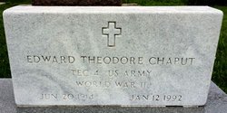
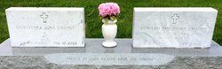
Edward Theodore Chaput
| Birth | : | 20 Jun 1914 Miltonvale, Cloud County, Kansas, USA |
| Death | : | 12 Jan 1992 Concordia, Cloud County, Kansas, USA |
| Burial | : | Mount Hope Cemetery, Clyde, Cloud County, USA |
| Coordinate | : | 39.5969009, -97.4116974 |
| Plot | : | Site 13-7A |
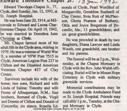
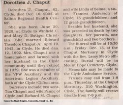
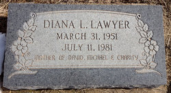
| Description | : | Salina Journal January 14, 1992 Edward Chaput Jr. CLYDE — Edward Theodore Chaput Jr., 77, Clyde, died Sunday, Jan. 12,1992, at the St. Joseph Hospital, Concordia. Mr. Chaput was born June 20, 1914, at Miltonvale and was a lifelong resident of the area. He was an Army veteran of World War II. He was a farmer, retiring in 1979, and was a member of the Veterans of Foreign Wars Post 7515, Clyde; American Legion Post 227, Clifton; and Disabled American Veterans Chapter 27, Clay Center. He was preceded in death by two daughters, Diana Lawyer and Linda Woods. Survivors include two sons, Richard of... Read More |
frequently asked questions (FAQ):
-
Where is Edward Theodore Chaput's memorial?
Edward Theodore Chaput's memorial is located at: Mount Hope Cemetery, Clyde, Cloud County, USA.
-
When did Edward Theodore Chaput death?
Edward Theodore Chaput death on 12 Jan 1992 in Concordia, Cloud County, Kansas, USA
-
Where are the coordinates of the Edward Theodore Chaput's memorial?
Latitude: 39.5969009
Longitude: -97.4116974
Family Members:
Parent

Spouse
Siblings

Children
Flowers:


Nearby Cemetories:
1. Mount Calvary Cemetery
Clyde, Cloud County, USA
Coordinate: 39.5917015, -97.4143982
2. Cedar Grove Cemetery
Clyde, Cloud County, USA
Coordinate: 39.5494003, -97.4056015
3. Pleasant View Cemetery
Ames, Cloud County, USA
Coordinate: 39.5346985, -97.4431000
4. Walnut Grove Cemetery
Cloud County, USA
Coordinate: 39.5699997, -97.4993973
5. Agenda Cemetery
Agenda, Republic County, USA
Coordinate: 39.6761017, -97.4336014
6. Saint Joseph Cemetery
Saint Joseph, Cloud County, USA
Coordinate: 39.5074941, -97.4022328
7. Beck Family Cemetery
Agenda, Republic County, USA
Coordinate: 39.6818000, -97.4863000
8. Green Mound Cemetery
Rice, Cloud County, USA
Coordinate: 39.5248450, -97.5081630
9. Hollis Cemetery
Cloud County, USA
Coordinate: 39.6383018, -97.5361023
10. Rice Cemetery
Rice, Cloud County, USA
Coordinate: 39.5614014, -97.5552979
11. Nelson Cemetery
Rice, Cloud County, USA
Coordinate: 39.5257988, -97.5410995
12. Riverdale Cemetery
Clay County, USA
Coordinate: 39.5106010, -97.2930984
13. Willoughby Cemetery
Agenda, Republic County, USA
Coordinate: 39.7402992, -97.4244003
14. Union Cemetery
Wayne, Republic County, USA
Coordinate: 39.6977997, -97.5457993
15. Saint Peters Cemetery
Aurora, Cloud County, USA
Coordinate: 39.4763985, -97.5180969
16. Princeville Cemetery
Aurora, Cloud County, USA
Coordinate: 39.4672012, -97.5010986
17. Iwacura Cemetery
Morganville, Clay County, USA
Coordinate: 39.4550000, -97.3510000
18. Gotland Cemetery
Sibley Township, Cloud County, USA
Coordinate: 39.6091995, -97.6125031
19. French Presbyterian Church Cemetery
Cloud County, USA
Coordinate: 39.4395200, -97.4148290
20. Sherman Cemetery
Morganville, Clay County, USA
Coordinate: 39.5316300, -97.2243700
21. Zion Cemetery
Agenda, Republic County, USA
Coordinate: 39.6749992, -97.5939026
22. Rose Hill Cemetery
Wayne, Republic County, USA
Coordinate: 39.7111015, -97.5661011
23. Minersville Cemetery
Talmo, Republic County, USA
Coordinate: 39.6568330, -97.6229250
24. Bloom Cemetery
Morganville, Clay County, USA
Coordinate: 39.4519005, -97.2778015