
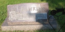
Donald Hawkins
| Birth | : | 11 Nov 1913 Mellette, Spink County, South Dakota, USA |
| Death | : | 8 Nov 1994 Redfield, Spink County, South Dakota, USA |
| Burial | : | St John the Baptist Churchyard, Baston, South Kesteven District, England |
| Coordinate | : | 52.7149530, -0.3530650 |
| Plot | : | 5 1/2 Lot 7 Grave 5 |
| Description | : | Donald Hawkins died at the age of 80yrs, he was buried 11 Nov 1994. He was the son of James and Anna Stratman Hawkins. 1936 he married Ruby Palmer the daughter of Herbert and Pearl May Jones Palmer. They were the parents of Terry, Mary and Sherilee. |
frequently asked questions (FAQ):
-
Where is Donald Hawkins's memorial?
Donald Hawkins's memorial is located at: St John the Baptist Churchyard, Baston, South Kesteven District, England.
-
When did Donald Hawkins death?
Donald Hawkins death on 8 Nov 1994 in Redfield, Spink County, South Dakota, USA
-
Where are the coordinates of the Donald Hawkins's memorial?
Latitude: 52.7149530
Longitude: -0.3530650
Family Members:
Parent

Spouse
Siblings
Flowers:


Nearby Cemetories:
1. St John the Baptist Churchyard
Baston, South Kesteven District, England
Coordinate: 52.7149530, -0.3530650
2. Baston Cemetery
Baston, South Kesteven District, England
Coordinate: 52.7149917, -0.3531338
3. St Michael and All Angels Churchyard
Langtoft, South Kesteven District, England
Coordinate: 52.6990300, -0.3389800
4. St Faith Churchyard
Wilsthorpe, South Kesteven District, England
Coordinate: 52.7095208, -0.3848166
5. St Firmin Churchyard
Thurlby, South Kesteven District, England
Coordinate: 52.7375960, -0.3646650
6. St Martin Churchyard
Barholm, South Kesteven District, England
Coordinate: 52.6855000, -0.3887600
7. St Medard and St Gildard Churchyard
Little Bytham, South Kesteven District, England
Coordinate: 52.6786110, -0.3200000
8. Bourne Cemetery
Bourne, South Kesteven District, England
Coordinate: 52.7607264, -0.3714663
9. St. Andrew's Churchyard
West Deeping, South Kesteven District, England
Coordinate: 52.6640285, -0.3614634
10. Bourne Abbey
Bourne, South Kesteven District, England
Coordinate: 52.7661320, -0.3758389
11. Saint Stephen
Carlby, South Kesteven District, England
Coordinate: 52.7125650, -0.4475800
12. St. Peter's Churchyard
Maxey, Peterborough Unitary Authority, England
Coordinate: 52.6575500, -0.3455940
13. St. James Cemetery
Deeping St James, South Kesteven District, England
Coordinate: 52.6716340, -0.2899500
14. St. James Churchyard
Deeping St James, South Kesteven District, England
Coordinate: 52.6716980, -0.2896360
15. St. Andrews Churchyard
Witham on the Hill, South Kesteven District, England
Coordinate: 52.7364500, -0.4420300
16. St Mary Magdalene Churchyard
Essendine, Rutland Unitary Authority, England
Coordinate: 52.7026000, -0.4489000
17. St. Lawrence's Churchyard
Tallington, South Kesteven District, England
Coordinate: 52.6574520, -0.3879120
18. St. Andrew's Churchyard
Northborough, Peterborough Unitary Authority, England
Coordinate: 52.6571000, -0.2974630
19. St Michael & All Angels Churchyard
Uffington, South Kesteven District, England
Coordinate: 52.6570400, -0.4321700
20. Ryhall Churchyard Extension
Ryhall, Rutland Unitary Authority, England
Coordinate: 52.6849000, -0.4678700
21. St John the Evangelist Churchyard
Ryhall, Rutland Unitary Authority, England
Coordinate: 52.6852000, -0.4685000
22. St Mary's Churchyard
Bainton, Peterborough Unitary Authority, England
Coordinate: 52.6411500, -0.3838900
23. Helpston Cemetery
Helpston, Peterborough Unitary Authority, England
Coordinate: 52.6374890, -0.3433900
24. St. Botolph Helpston Churchyard
Helpston, Peterborough Unitary Authority, England
Coordinate: 52.6359090, -0.3435870