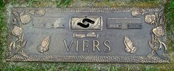
| Birth | : | 27 Apr 1925 Collins, Story County, Iowa, USA |
| Death | : | 26 Feb 2007 Marshalltown, Marshall County, Iowa, USA |
| Burial | : | St Mary's Churchyard Extension, Banham, Breckland Borough, England |
| Coordinate | : | 52.4549400, 1.0274400 |
| Description | : | *** IN LOVING MEMORY OF *** Donald W. Viers was born near Collins; Story County, Iowa on Saturday; April 25, 1925 to Richard and Ora Viers. He was the youngest of ten children and attended school at Rhodes. Donald served our country proudly in the United States Army enlisting at age 18. He fought in the Battle of the Bulge and also received a commendation from the people of Norway for his help in the Liberation of Norway on Tuesday; May 8, 1945. Donald was married to Edith Cook. He lived and worked in the Marshalltown area... Read More |
frequently asked questions (FAQ):
-
Where is Donald Wayne Viers's memorial?
Donald Wayne Viers's memorial is located at: St Mary's Churchyard Extension, Banham, Breckland Borough, England.
-
When did Donald Wayne Viers death?
Donald Wayne Viers death on 26 Feb 2007 in Marshalltown, Marshall County, Iowa, USA
-
Where are the coordinates of the Donald Wayne Viers's memorial?
Latitude: 52.4549400
Longitude: 1.0274400
Family Members:
Parent
Spouse
Siblings
Children
Flowers:
Nearby Cemetories:
1. St Mary's Churchyard Extension
Banham, Breckland Borough, England
Coordinate: 52.4549400, 1.0274400
2. St. Mary the Virgin Churchyard
Banham, Breckland Borough, England
Coordinate: 52.4529230, 1.0353120
3. Theddingworth Congregational Church yard
Theddingworth, Harborough District, England
Coordinate: 52.4644400, 1.0211700
4. Carmelite Monastery Cemetery
Quideham, Breckland Borough, England
Coordinate: 52.4498000, 0.9894000
5. Saint Mary Churchyard
Kenninghall, Breckland Borough, England
Coordinate: 52.4336980, 1.0010730
6. The Chapel Graveyard
Kenninghall, Breckland Borough, England
Coordinate: 52.4359530, 0.9961130
7. St Andrews Churchyard
Quideham, Breckland Borough, England
Coordinate: 52.4493470, 0.9835550
8. All Saints Churchyard
Old Buckenham, Breckland Borough, England
Coordinate: 52.4816260, 1.0433160
9. St. Martin's Churchyard
New Buckenham, Breckland Borough, England
Coordinate: 52.4728860, 1.0728380
10. St. Mary the Virgin Churchyard
Eccles, Breckland Borough, England
Coordinate: 52.4649373, 0.9707904
11. Buckenham Priory
Buckenham, Broadland District, England
Coordinate: 52.4911000, 1.0497000
12. All Saints Churchyard Hargham
Quideham, Breckland Borough, England
Coordinate: 52.4826470, 0.9732300
13. St Andrew Churchyard
Fersfield, South Norfolk District, England
Coordinate: 52.4043450, 1.0351310
14. Methodist Churchyard
North Lopham, Breckland Borough, England
Coordinate: 52.4053630, 0.9920680
15. St Nicholas Churchyard
North Lopham, Breckland Borough, England
Coordinate: 52.4029430, 0.9920510
16. East Harling Cemetery
East Harling, Breckland Borough, England
Coordinate: 52.4336498, 0.9346589
17. St Peter & St Paul Church
Norwich, City of Norwich, England
Coordinate: 52.4408990, 0.9299175
18. All Saints Churchyard
Shelfanger, South Norfolk District, England
Coordinate: 52.4104780, 1.0969230
19. St Peter and St Paul Churchyard
East Harling, Breckland Borough, England
Coordinate: 52.4373860, 0.9304050
20. Parkside Garden
Attleborough, Breckland Borough, England
Coordinate: 52.5167420, 1.0209100
21. All Saints Churchyard
Snetterton, Breckland Borough, England
Coordinate: 52.4807600, 0.9350140
22. St Andrew Churchyard
South Lopham, Breckland Borough, England
Coordinate: 52.3957830, 0.9969650
23. All Saints Churchyard
Carleton Rode, South Norfolk District, England
Coordinate: 52.4892230, 1.1133590
24. Blessed Virgin Mary Churchyard
Attleborough, Breckland Borough, England
Coordinate: 52.5178950, 1.0181880


