
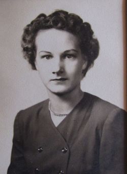
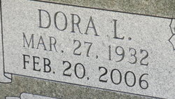


Dora L Stout Gasswint
| Birth | : | 27 Mar 1932 |
| Death | : | 20 Feb 2006 |
| Burial | : | Rose Meron Cemetery, Oak Hill, Clay County, USA |
| Coordinate | : | 39.2194700, -97.3338900 |
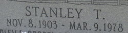
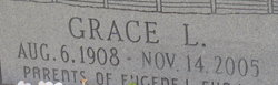
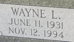
| Description | : | Dora L. Gasswint, 73, Abilene, Kansas, died Monday, February 20th 2006, at Salina Regional Health Center, Salina, Kansas. She was born March 27th 1932, north of Longford, Kansas, the daughter of Stanley and Grace (Young) Stout. She attended Pleasant Valley grade school and graduated from Longford High School in 1050. She moved to Abilene in 1951. She married Wayne L. Gasswint on March 27th 1951. All their married life was spent in Abilene. He preceded her in death on November 12th 1994. Dora worked for South Western Bell, retiring in 1981. She also operated the Sewing Basket and drove a school bus for... Read More |
frequently asked questions (FAQ):
-
Where is Dora L Stout Gasswint's memorial?
Dora L Stout Gasswint's memorial is located at: Rose Meron Cemetery, Oak Hill, Clay County, USA.
-
When did Dora L Stout Gasswint death?
Dora L Stout Gasswint death on 20 Feb 2006 in
-
Where are the coordinates of the Dora L Stout Gasswint's memorial?
Latitude: 39.2194700
Longitude: -97.3338900
Family Members:
Parent
Spouse
Siblings
Flowers:


Nearby Cemetories:
1. Rose Meron Cemetery
Oak Hill, Clay County, USA
Coordinate: 39.2194700, -97.3338900
2. Pleasant Valley Cemetery
Oak Hill, Clay County, USA
Coordinate: 39.2468987, -97.2889023
3. Wesleyan Cemetery
Oak Hill, Clay County, USA
Coordinate: 39.2268982, -97.2572021
4. Mount Liberty Church Cemetery
Ottawa County, USA
Coordinate: 39.2489400, -97.4356200
5. Swartwood Cemetery
Longford, Clay County, USA
Coordinate: 39.1323200, -97.3431500
6. Shields Cemetery
Clay County, USA
Coordinate: 39.3208008, -97.3507996
7. Table Mound Cemetery
Idana, Clay County, USA
Coordinate: 39.3141300, -97.2792300
8. Keystone Cemetery
Manchester, Dickinson County, USA
Coordinate: 39.1185989, -97.2917023
9. Hebron Cemetery
Clay County, USA
Coordinate: 39.3213800, -97.2601400
10. Vine Creek Cemetery
Ottawa County, USA
Coordinate: 39.1194000, -97.4180984
11. Athelstane Cemetery
Athelstane Township, Clay County, USA
Coordinate: 39.1768990, -97.1753006
12. Pleasant Ridge Cemetery
Clay County, USA
Coordinate: 39.2789001, -97.1841965
13. Miltonvale Cemetery
Miltonvale, Cloud County, USA
Coordinate: 39.3358002, -97.4447021
14. White Cloud Cemetery
Manchester, Dickinson County, USA
Coordinate: 39.0744019, -97.3525009
15. Idana Cemetery
Idana, Clay County, USA
Coordinate: 39.3574500, -97.2693300
16. Zion Lutheran Cemetery
Clay County, USA
Coordinate: 39.2928009, -97.1557999
17. Mizpah Cemetery
Clay County, USA
Coordinate: 39.2057800, -97.1238500
18. Smith Grave
Miltonvale, Cloud County, USA
Coordinate: 39.3645300, -97.4308700
19. Fairview Cemetery
Lamar, Ottawa County, USA
Coordinate: 39.2928009, -97.5299988
20. Ackley Cemetery
Ottawa County, USA
Coordinate: 39.0893160, -97.4797040
21. Greenridge Cemetery
Dickinson County, USA
Coordinate: 39.1199989, -97.1433029
22. Henry Cemetery
Buckeye, Dickinson County, USA
Coordinate: 39.0828018, -97.1857986
23. Prairiedale Cemetery
Talmage, Dickinson County, USA
Coordinate: 39.0471992, -97.2652969
24. Republican City Cemetery
Clay Center, Clay County, USA
Coordinate: 39.3431015, -97.1628036