
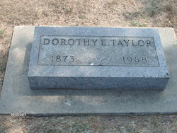
Dorothy Eleanor Clark Taylor
| Birth | : | 1873 Kansas, USA |
| Death | : | 26 Aug 1968 Jamestown, Cloud County, Kansas, USA |
| Burial | : | Center Cemetery, Rochester, Plymouth County, USA |
| Coordinate | : | 41.7301530, -70.8185830 |
| Plot | : | 22-111 |
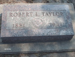
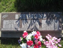
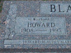
| Description | : | Dorothy Eleanor Clark married 1) (____) Blachly by 1906, and had Clark Blachly and Howard Blachly in Oklahoma. She married 2) Robert L. Taylor, of Cloud Co, Kansas. They had no children. They raised Clark and Howard Blachly. They lived in Summit Township in Cloud County their entire married life. She moved into Jamestown after Robert died. She died at age 95. Note: bio info provided by Silverfox (#47344111) |
frequently asked questions (FAQ):
-
Where is Dorothy Eleanor Clark Taylor's memorial?
Dorothy Eleanor Clark Taylor's memorial is located at: Center Cemetery, Rochester, Plymouth County, USA.
-
When did Dorothy Eleanor Clark Taylor death?
Dorothy Eleanor Clark Taylor death on 26 Aug 1968 in Jamestown, Cloud County, Kansas, USA
-
Where are the coordinates of the Dorothy Eleanor Clark Taylor's memorial?
Latitude: 41.7301530
Longitude: -70.8185830
Family Members:
Spouse
Children
Flowers:


Nearby Cemetories:
1. Center Cemetery
Rochester, Plymouth County, USA
Coordinate: 41.7301530, -70.8185830
2. Ellis Family Burial Ground
Rochester, Plymouth County, USA
Coordinate: 41.7105620, -70.8397580
3. Union Cemetery
Rochester, Plymouth County, USA
Coordinate: 41.7573640, -70.8202030
4. Perry Family Cemetery
Rochester, Plymouth County, USA
Coordinate: 41.7501840, -70.7914780
5. North Marion Cemetery
Marion, Plymouth County, USA
Coordinate: 41.7280884, -70.7763062
6. Friends Burial Ground
Marion, Plymouth County, USA
Coordinate: 41.7279129, -70.7757416
7. Howse Family Burial Ground
Rochester, Plymouth County, USA
Coordinate: 41.7262300, -70.8632760
8. Sherman Cemetery
Rochester, Plymouth County, USA
Coordinate: 41.7467728, -70.8678284
9. Old Landing Cemetery
Marion, Plymouth County, USA
Coordinate: 41.7103004, -70.7707977
10. Ellis Cemetery
Mattapoisett, Plymouth County, USA
Coordinate: 41.6957817, -70.8545609
11. Little Neck Cemetery
Marion, Plymouth County, USA
Coordinate: 41.7175200, -70.7624900
12. Evergreen Cemetery
Marion, Plymouth County, USA
Coordinate: 41.6985435, -70.7698517
13. Hillside Cemetery
Rochester, Plymouth County, USA
Coordinate: 41.7750015, -70.7889023
14. Saint Gabriels Episcopal Memorial Garden
Marion, Plymouth County, USA
Coordinate: 41.7020200, -70.7626500
15. Saint Anthonys Cemetery
Mattapoisett, Plymouth County, USA
Coordinate: 41.6781060, -70.8271560
16. Burnham Cemetery
Acushnet, Bristol County, USA
Coordinate: 41.7090300, -70.8885400
17. Long Plain Cemetery
Acushnet, Bristol County, USA
Coordinate: 41.7326100, -70.8943000
18. Woodside Cemetery
Rochester, Plymouth County, USA
Coordinate: 41.7848816, -70.7774887
19. Blankenship Cemetery
Marion, Plymouth County, USA
Coordinate: 41.7076200, -70.7392100
20. Point Road Memorial Forest
Marion, Plymouth County, USA
Coordinate: 41.7071400, -70.7385050
21. Long Plain Friends Cemetery
Acushnet, Bristol County, USA
Coordinate: 41.7471580, -70.9018400
22. Barlow Cemetery
Mattapoisett, Plymouth County, USA
Coordinate: 41.6641045, -70.8232269
23. Pierce Family Cemetery
Rochester, Plymouth County, USA
Coordinate: 41.7838890, -70.8722220
24. Hammond Cemetery
Mattapoisett, Plymouth County, USA
Coordinate: 41.6638300, -70.8351500