
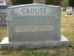
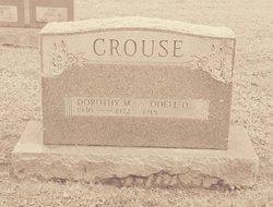
Dorothy Mae Tosten Crouse
| Birth | : | 3 Sep 1930 Hagerstown, Washington County, Maryland, USA |
| Death | : | 17 Dec 1972 Darlington, Harford County, Maryland, USA |
| Burial | : | Helensville Cemetery, Helensville, Auckland Council, New Zealand |
| Coordinate | : | -36.6832600, 174.4548700 |
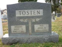
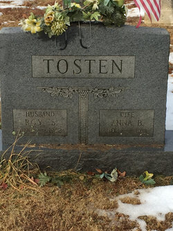
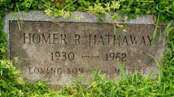
| Description | : | Daughter of Roy Samuel Tosten Sr. 1898-1962 & Anna Belva Deckman Tosten 1902-1983 Husband #1 Homer Hathaway 1930-1962 Husband #2 Odel O. Crouse 1918-2007 |
frequently asked questions (FAQ):
-
Where is Dorothy Mae Tosten Crouse's memorial?
Dorothy Mae Tosten Crouse's memorial is located at: Helensville Cemetery, Helensville, Auckland Council, New Zealand.
-
When did Dorothy Mae Tosten Crouse death?
Dorothy Mae Tosten Crouse death on 17 Dec 1972 in Darlington, Harford County, Maryland, USA
-
Where are the coordinates of the Dorothy Mae Tosten Crouse's memorial?
Latitude: -36.6832600
Longitude: 174.4548700
Family Members:
Parent
Spouse
Siblings
Flowers:


Nearby Cemetories:
1. Helensville Cemetery
Helensville, Auckland Council, New Zealand
Coordinate: -36.6832600, 174.4548700
2. Kaukapakapa Public Cemetery
Kaukapakapa, Auckland Council, New Zealand
Coordinate: -36.6397740, 174.5057450
3. Kaukapakapa Cemetery
Kaukapakapa, Auckland Council, New Zealand
Coordinate: -36.6268500, 174.5013400
4. Kumeu Anglican Cemetery
Kumeu, Auckland Council, New Zealand
Coordinate: -36.7861800, 174.5500100
5. Wainui Settlers Cemetery
Wainui, Auckland Council, New Zealand
Coordinate: -36.6077200, 174.6324400
6. Wainui Public Cemetery
Wainui, Auckland Council, New Zealand
Coordinate: -36.6069500, 174.6322800
7. Kaipara Flats Cemetery
Kaipara Flats, Auckland Council, New Zealand
Coordinate: -36.5017800, 174.4534100
8. Auckland Memorial Park Cemetery
Silverdale, Auckland Council, New Zealand
Coordinate: -36.6273150, 174.6725690
9. Komokoriki Cemetery
Manukau, Auckland Council, New Zealand
Coordinate: -36.5026370, 174.5033710
10. North Shore Memorial Park
Auckland, Auckland Council, New Zealand
Coordinate: -36.7545800, 174.6838900
11. Hobsonville Church and Settlers' Cemetery
Hobsonville, Auckland Council, New Zealand
Coordinate: -36.8000500, 174.6551800
12. Albany Village Cemetery
Albany, Auckland Council, New Zealand
Coordinate: -36.7298900, 174.6972700
13. Holy Trinity Cemetery
Silverdale, Auckland Council, New Zealand
Coordinate: -36.7429008, 174.6940822
14. Swanson Cemetery
Swanson, Auckland Council, New Zealand
Coordinate: -36.8718400, 174.5836200
15. Glorit Cemetery
Glorit, Auckland Council, New Zealand
Coordinate: -36.4599760, 174.4448830
16. Puhoi Cemetery
Puhoi, Auckland Council, New Zealand
Coordinate: -36.5052400, 174.6476300
17. St. Mary's Pioneer Cemetery
Torbay, Auckland Council, New Zealand
Coordinate: -36.6959500, 174.7512400
18. Stanmore Bay Beach Cemetery
Whangaparāoa, Auckland Council, New Zealand
Coordinate: -36.6244131, 174.7445165
19. Birkenhead-Glenfield Cemetery
Birkenhead, Auckland Council, New Zealand
Coordinate: -36.7989000, 174.7234700
20. Pompallier Cemetery
Birkenhead, Auckland Council, New Zealand
Coordinate: -36.8036900, 174.7251200
21. Settlers Cemetery
Oratia, Auckland Council, New Zealand
Coordinate: -36.9108770, 174.6218870
22. Oratia Cemetery
Oratia, Auckland Council, New Zealand
Coordinate: -36.9108800, 174.6218900
23. Pukapuka Cemetery
Pohuehue, Auckland Council, New Zealand
Coordinate: -36.4858910, 174.6783405
24. Oratia Combined Church Cemetery
Oratia, Auckland Council, New Zealand
Coordinate: -36.9196396, 174.6119362