
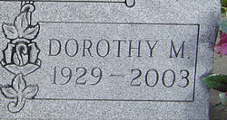

Dorothy Marie Boese Johnson
| Birth | : | 19 Feb 1929 |
| Death | : | 27 Dec 2003 |
| Burial | : | St Andrew Churchyard, Stogursey, West Somerset District, England |
| Coordinate | : | 51.1795900, -3.1392800 |
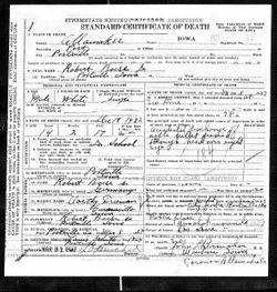
| Description | : | Dorothy Marie Johnson was born February 19, 1929, at Postville, Iowa, the daughter of Robert Boese and Dorothy Freeman Boese. She passed away Saturday, December 27, 2003, in the Good Samaritan Center at Postville, Iowa. Dorothy attended the Postville Schools. Dorothy was married to Norman Johnson on September 20, 1950, at the Little Brown Church in Nashua, Iowa. To this union three children were born. In her early years, Dorothy worked at the Rima Cafe in Postville. For 21 years she was employed as a supervisor at the Iowa Turkey Products Plant. |
frequently asked questions (FAQ):
-
Where is Dorothy Marie Boese Johnson's memorial?
Dorothy Marie Boese Johnson's memorial is located at: St Andrew Churchyard, Stogursey, West Somerset District, England.
-
When did Dorothy Marie Boese Johnson death?
Dorothy Marie Boese Johnson death on 27 Dec 2003 in
-
Where are the coordinates of the Dorothy Marie Boese Johnson's memorial?
Latitude: 51.1795900
Longitude: -3.1392800
Family Members:
Parent
Spouse
Siblings
Flowers:


Nearby Cemetories:
1. St Andrew Churchyard
Stogursey, West Somerset District, England
Coordinate: 51.1795900, -3.1392800
2. Stogursey Extension Cemetery
Stogursey, West Somerset District, England
Coordinate: 51.1793740, -3.1398040
3. Burton Baptist Chapel
Stogursey, West Somerset District, England
Coordinate: 51.1910560, -3.1560340
4. St. Martin's Churchyard
Fiddington, Sedgemoor District, England
Coordinate: 51.1591640, -3.1229530
5. St. Mary's Churchyard
Stringston, West Somerset District, England
Coordinate: 51.1748960, -3.1795460
6. St. Mary's Churchyard
Nether Stowey, Sedgemoor District, England
Coordinate: 51.1502280, -3.1494270
7. Nether Stowey Cemetery
Nether Stowey, Sedgemoor District, England
Coordinate: 51.1498667, -3.1530087
8. St.Mary Magdalene
Stockland Bristol, Sedgemoor District, England
Coordinate: 51.1867260, -3.0886950
9. All Saints Churchyard
Dodington, West Somerset District, England
Coordinate: 51.1583770, -3.1854620
10. St. Nicholas's Churchyard
Holford, West Somerset District, England
Coordinate: 51.1902700, -3.1949170
11. All Saints Churchyard
Otterhampton, Sedgemoor District, England
Coordinate: 51.1829540, -3.0796420
12. Otterhampton Extension Cemetery
Otterhampton, Sedgemoor District, England
Coordinate: 51.1828490, -3.0791630
13. St. Andrew's Churchyard
Lilstock, West Somerset District, England
Coordinate: 51.1971070, -3.1936420
14. Over Stowey Cemetery
Over Stowey, Sedgemoor District, England
Coordinate: 51.1404020, -3.1661850
15. St Peter and St Paul Churchyard
Over Stowey, Sedgemoor District, England
Coordinate: 51.1399680, -3.1656040
16. St. Mary's Churchyard
Holford, West Somerset District, England
Coordinate: 51.1627900, -3.2074238
17. Cannington Cemetery
Cannington, Sedgemoor District, England
Coordinate: 51.1500620, -3.0697070
18. St Mary's Churchyard
Kilve, West Somerset District, England
Coordinate: 51.1883100, -3.2223530
19. Charlynch Church of Saint Mary
Spaxton, Sedgemoor District, England
Coordinate: 51.1342600, -3.0879100
20. Saint Margaret's Churchyard
Spaxton, Sedgemoor District, England
Coordinate: 51.1273090, -3.1087000
21. Spaxton Extension Cemetery
Spaxton, Sedgemoor District, England
Coordinate: 51.1267650, -3.1082920
22. Blessed Virgin Mary Churchyard
Cannington, Sedgemoor District, England
Coordinate: 51.1500970, -3.0622850
23. St. Mary's Churchyard
East Quantoxhead, West Somerset District, England
Coordinate: 51.1855220, -3.2370690
24. All Saints Churchyard
Aisholt, Sedgemoor District, England
Coordinate: 51.1142070, -3.1532890