

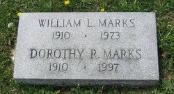
Dorothy Ruth Stratton Marks
| Birth | : | 18 May 1910 Sullivan, Sullivan County, Indiana, USA |
| Death | : | 14 Feb 1997 Honolulu, Honolulu County, Hawaii, USA |
| Burial | : | St Andrew Churchyard, South Stoke, South Oxfordshire District, England |
| Coordinate | : | 51.5479065, -1.1377167 |
| Plot | : | Section 10 |
| Description | : | Dorothy R. Marks, 86, of Honolulu, died Feb. 14 in Maunalani Nursing Center. Born in Sullivan, Ind., she is survived by son William L. Marks and daughter Sarah M. Richards. Service: 4 p.m. today at Central Union Church. Burial on the mainland. Donations suggested to the Hawaii Opera Theatre and the Hawaii Theatre Center. Source; The Honolulu Star-Bulletin Wednesday, March 5, 1997 Obituary courtesy of Larry Pauly (49188329) Graduate of DePauw Univ. in 1932. After her husband's death she moved to Honolulu, HI. |
frequently asked questions (FAQ):
-
Where is Dorothy Ruth Stratton Marks's memorial?
Dorothy Ruth Stratton Marks's memorial is located at: St Andrew Churchyard, South Stoke, South Oxfordshire District, England.
-
When did Dorothy Ruth Stratton Marks death?
Dorothy Ruth Stratton Marks death on 14 Feb 1997 in Honolulu, Honolulu County, Hawaii, USA
-
Where are the coordinates of the Dorothy Ruth Stratton Marks's memorial?
Latitude: 51.5479065
Longitude: -1.1377167
Family Members:
Parent
Spouse
Siblings
Flowers:


Nearby Cemetories:
1. St Andrew Churchyard
South Stoke, South Oxfordshire District, England
Coordinate: 51.5479065, -1.1377167
2. St John the Baptist
Moulsford, South Oxfordshire District, England
Coordinate: 51.5531050, -1.1482640
3. St. Mary Churchyard
Streatley, West Berkshire Unitary Authority, England
Coordinate: 51.5240170, -1.1449500
4. St. Mary's Churchyard
North Stoke, South Oxfordshire District, England
Coordinate: 51.5714910, -1.1228080
5. St. Thomas of Canterbury Churchyard
Goring, South Oxfordshire District, England
Coordinate: 51.5221440, -1.1399970
6. Whitehill Burial Ground
Goring, South Oxfordshire District, England
Coordinate: 51.5214730, -1.1180180
7. St. Mary's Churchyard
Cholsey, South Oxfordshire District, England
Coordinate: 51.5788078, -1.1589500
8. St. Mary the Virgin Cemetery
Ipsden, South Oxfordshire District, England
Coordinate: 51.5674164, -1.0866686
9. St. John the Baptist Church (Defunct)
Mongwell, South Oxfordshire District, England
Coordinate: 51.5860980, -1.1233580
10. St. Leonard's Churchyard
Woodcote, South Oxfordshire District, England
Coordinate: 51.5348117, -1.0731299
11. St Michael's Cemetery
Aston Tirrold, South Oxfordshire District, England
Coordinate: 51.5730994, -1.1967145
12. All Saints Churchyard
Aston Upthorpe, South Oxfordshire District, England
Coordinate: 51.5715900, -1.2037500
13. St. Leonard's Churchyard
Wallingford, South Oxfordshire District, England
Coordinate: 51.5972711, -1.1230712
14. St. John the Baptist South Moreton
South Moreton, South Oxfordshire District, England
Coordinate: 51.5881630, -1.1895850
15. St. Mary-le-More Churchyard
Wallingford, South Oxfordshire District, England
Coordinate: 51.5993878, -1.1249488
16. St Mary Magdalene Churchyard
Crowmarsh Gifford, South Oxfordshire District, England
Coordinate: 51.5992169, -1.1139564
17. Saint Peter's Churchyard
Wallingford, South Oxfordshire District, England
Coordinate: 51.6005819, -1.1215970
18. South Moreton Strict Baptist Chapel
South Moreton, South Oxfordshire District, England
Coordinate: 51.5900300, -1.1924310
19. All Hallows Graveyard
Wallingford, South Oxfordshire District, England
Coordinate: 51.6020520, -1.1242267
20. St. John the Baptist Churchyard
Whitchurch Hill, South Oxfordshire District, England
Coordinate: 51.5050469, -1.0824315
21. St. Mary the Virgin Churchyard
Aldworth, West Berkshire Unitary Authority, England
Coordinate: 51.5106800, -1.2030150
22. Checkendon Churchyard
Checkendon, South Oxfordshire District, England
Coordinate: 51.5424461, -1.0449720
23. Wallingford Cemetery
Wallingford, South Oxfordshire District, England
Coordinate: 51.6058200, -1.1232000
24. All Saints Churchyard
North Moreton, South Oxfordshire District, England
Coordinate: 51.6021922, -1.1898247