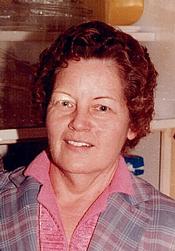
Dovie Lamb Gore Clements
| Birth | : | 20 Sep 1899 Sevier County, Arkansas, USA |
| Death | : | 25 Mar 1987 Sevier County, Arkansas, USA |
| Burial | : | St Mary the Virgin Churchyard, Morcott, Rutland Unitary Authority, England |
| Coordinate | : | 52.5967800, -0.6366200 |
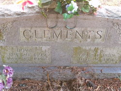
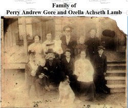
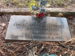
| Description | : | Dovey Lamb Clements was born To Andrew perry and Georgiana Elezebeth Adair Gore on Sept.20,1899-d.March 26,1987 she married Nepolean "Poley" Clements on Sept.22,1920. Dovie and Poley lived in Sevier Co. all there lives,mostly around the Walnut Springs area. they farmed and attended the Methodist church at Walnut Springs. ------------------------------------------------------- Dovie Lamb Gore CLEMENTS Married Napolean Polly CLEMENTS Sept 22, 1920 They had seven children; Virgie Maurine b.Aug.10,1921 Ozella Corine b.Sept.19,1922 Lincoln Napolean "Jack"b.Dec.3,1923 Robert Clements b.May 27,1925-d.June 5,1925 (Buried in Millwee cemetery.) Ella Geraldine b.Nov.13,1927 Samuel Andrew "Sam" b.Nov.20,1929-d.March 4,1988 (Buried in Millwee cemetery) Ora Lee b.March 6,1934 |
frequently asked questions (FAQ):
-
Where is Dovie Lamb Gore Clements's memorial?
Dovie Lamb Gore Clements's memorial is located at: St Mary the Virgin Churchyard, Morcott, Rutland Unitary Authority, England.
-
When did Dovie Lamb Gore Clements death?
Dovie Lamb Gore Clements death on 25 Mar 1987 in Sevier County, Arkansas, USA
-
Where are the coordinates of the Dovie Lamb Gore Clements's memorial?
Latitude: 52.5967800
Longitude: -0.6366200
Family Members:
Parent
Spouse
Siblings
Children
Nearby Cemetories:
1. St Mary the Virgin Churchyard
Morcott, Rutland Unitary Authority, England
Coordinate: 52.5967800, -0.6366200
2. St Mary the Virgin Churchyard
South Luffenham, Rutland Unitary Authority, England
Coordinate: 52.6067200, -0.6114100
3. St. Peter's Churchyard
Barrowden, Rutland Unitary Authority, England
Coordinate: 52.5888800, -0.6063600
4. St Nicholas Churchyard
Pilton, Rutland Unitary Authority, England
Coordinate: 52.6165200, -0.6504100
5. St. John The Baptist Church
North Luffenham, Rutland Unitary Authority, England
Coordinate: 52.6186570, -0.6211140
6. St. Andrew's Churchyard
Glaston, Rutland Unitary Authority, England
Coordinate: 52.5953628, -0.6781534
7. All Hallows Churchyard
Seaton, Rutland Unitary Authority, England
Coordinate: 52.5745730, -0.6670810
8. Church of Saint John the Baptist
Wakerley, East Northamptonshire Borough, England
Coordinate: 52.5817323, -0.5929850
9. Saint John The Baptist Churchyard
Harringworth, East Northamptonshire Borough, England
Coordinate: 52.5671000, -0.6491000
10. St. Peter and St. Paul's Churchyard
Wing, Rutland Unitary Authority, England
Coordinate: 52.6172140, -0.6814150
11. St Mary the Virgin Churchyard
Edith Weston, Rutland Unitary Authority, England
Coordinate: 52.6379100, -0.6311100
12. All Saints Churchyard
Laxton, East Northamptonshire Borough, England
Coordinate: 52.5535760, -0.5992450
13. St Peter & Paul Churchyard
Preston, Rutland Unitary Authority, England
Coordinate: 52.6122600, -0.7162560
14. St. Peter and St. Paul's Churchyard
Uppingham, Rutland Unitary Authority, England
Coordinate: 52.5873820, -0.7221660
15. Uppingham Lawn Cemetery
Uppingham, Rutland Unitary Authority, England
Coordinate: 52.5855800, -0.7229700
16. Ketton Park Burial Ground
Ketton, Rutland Unitary Authority, England
Coordinate: 52.6240570, -0.5604330
17. Church of St Mary
Duddington, East Northamptonshire Borough, England
Coordinate: 52.5969190, -0.5432540
18. St. Mary the Virgin Churchyard
Uppingham, Rutland Unitary Authority, England
Coordinate: 52.5996800, -0.7324400
19. Ketton St Mary the Virgin Churchyard
Ketton, Rutland Unitary Authority, England
Coordinate: 52.6274671, -0.5509559
20. St. James Churchyard
Gretton, Corby Borough, England
Coordinate: 52.5403000, -0.6763400
21. Holy Trinity Churchyard
Blatherwycke, East Northamptonshire Borough, England
Coordinate: 52.5514375, -0.5646654
22. Leicester Road Cemetery
Uppingham, Rutland Unitary Authority, England
Coordinate: 52.5975766, -0.7413414
23. St Andrew Churchyard
Hambleton, Rutland Unitary Authority, England
Coordinate: 52.6585060, -0.6712280
24. Collyweston Cemetery
Collyweston, East Northamptonshire Borough, England
Coordinate: 52.6115580, -0.5319430

