
| Birth | : | 22 Jan 1872 Guttenberg, Clayton County, Iowa, USA |
| Death | : | 22 Jan 1934 Postville, Allamakee County, Iowa, USA |
| Burial | : | Garnavillo Community Cemetery, Garnavillo, Clayton County, USA |
| Coordinate | : | 42.8656000, -91.2422100 |
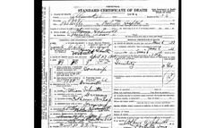
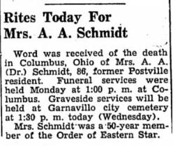
| Description | : | Postville Herald, IA, Thursday, January 25, 1934, pg. 1, col. 6 Dr. A. A. Schmidt, Prominent Local Physician, Passes Founder of Local Hospital Had Lived Here Over Twenty-seven Years At a little past three o'clock on Monday afternoon of this week the people of Postville and vicinity were again shocked and saddened as the sorry news was spread quickly and quietly about that Dr. A. A. Schmidt had passed away at Postville Hospital, his demise following a severe attack of streptococcic throat with which he was stricken last Thursday, his death occurring on the sixty-second anniversary of his birth. Dr. Arthur Albert Schmidt, an... Read More |
frequently asked questions (FAQ):
-
Where is Dr Arthur Albert Schmidt's memorial?
Dr Arthur Albert Schmidt's memorial is located at: Garnavillo Community Cemetery, Garnavillo, Clayton County, USA.
-
When did Dr Arthur Albert Schmidt death?
Dr Arthur Albert Schmidt death on 22 Jan 1934 in Postville, Allamakee County, Iowa, USA
-
Where are the coordinates of the Dr Arthur Albert Schmidt's memorial?
Latitude: 42.8656000
Longitude: -91.2422100
Family Members:
Parent
Spouse
Children

Flowers:


Nearby Cemetories:
1. Garnavillo Community Cemetery
Garnavillo, Clayton County, USA
Coordinate: 42.8656000, -91.2422100
2. Garnavillo Cemetery
Garnavillo, Clayton County, USA
Coordinate: 42.8660300, -91.2390100
3. Saint Joseph Cemetery
Garnavillo, Clayton County, USA
Coordinate: 42.8628006, -91.2502975
4. McClelland Cemetery
Garnavillo, Clayton County, USA
Coordinate: 42.8249879, -91.2084641
5. Pioneer Rock Cemetery
Ceres, Clayton County, USA
Coordinate: 42.8230591, -91.1863937
6. Clayton Center Cemetery
Clayton Center, Clayton County, USA
Coordinate: 42.8841705, -91.3225021
7. Zion Lutheran Cemetery
Clayton Center, Clayton County, USA
Coordinate: 42.8841705, -91.3249969
8. Clayton Cemetery
Clayton, Clayton County, USA
Coordinate: 42.9043999, -91.1641998
9. Tangeman Family Cemetery
Garnavillo, Clayton County, USA
Coordinate: 42.8580000, -91.1420000
10. Saint Michael Cemetery
Clayton County, USA
Coordinate: 42.8055992, -91.1802979
11. County Home Cemetery
Clayton Center, Clayton County, USA
Coordinate: 42.8916702, -91.3499985
12. Krumm Cemetery
Garber, Clayton County, USA
Coordinate: 42.7913760, -91.3023559
13. Colony Catholic Cemetery (Defunct)
Read Township, Clayton County, USA
Coordinate: 42.8830000, -91.3580000
14. Borcherding Cemetery
Jefferson Township, Clayton County, USA
Coordinate: 42.8182983, -91.1414032
15. National Cemetery
National, Clayton County, USA
Coordinate: 42.9536018, -91.2902985
16. Storck Cemetery
Guttenberg, Clayton County, USA
Coordinate: 42.7694335, -91.1834638
17. Harford Cemetery
Wyalusing, Grant County, USA
Coordinate: 42.9401000, -91.1401800
18. Saint Paula Cemetery
Osterdock, Clayton County, USA
Coordinate: 42.7635994, -91.1992035
19. Meenan Cemetery
Communia, Clayton County, USA
Coordinate: 42.7999862, -91.3584693
20. Norwegian Church Cemetery
McGregor, Clayton County, USA
Coordinate: 42.9644400, -91.1764100
21. Old Garber Cemetery
Garber, Clayton County, USA
Coordinate: 42.7560005, -91.2580032
22. Elkader Cemetery
Elkader, Clayton County, USA
Coordinate: 42.8541718, -91.4000015
23. Bagley Cemetery
Bagley, Grant County, USA
Coordinate: 42.9019012, -91.0907974
24. First Evangelical Lutheran Church Cemetery
McGregor, Clayton County, USA
Coordinate: 42.9718000, -91.1760000