
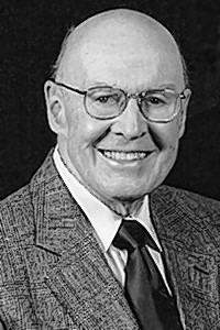

Dr Dale Swartzendruber
| Birth | : | 6 Jul 1925 |
| Death | : | 21 Oct 2014 |
| Burial | : | Lower Deer Creek Cemetery, Johnson County, USA |
| Coordinate | : | 41.5381012, -91.7985992 |
| Description | : | Dale was born July 6, 1925, near Parnell, Iowa, the son of Urie and Norma (Kinsinger) Swartzen-druber. He earned his high school diploma by taking correspondence courses through the American School. From 1945 to 1946, he served in Civilian Public Service (CPS) in Montana and Nebraska. He attended Goshen College and later transferred to Iowa State University, where he received his Bachelor of Science degree in soils and master's degree and Ph.D. in soil physics. He married Kathleen Jeanette Yoder on June 26, 1949, at Lower Deer Creek Mennonite Church. Kathleen passed away Nov. 8, 2012. From 1953 to 1954, Dale... Read More |
frequently asked questions (FAQ):
-
Where is Dr Dale Swartzendruber's memorial?
Dr Dale Swartzendruber's memorial is located at: Lower Deer Creek Cemetery, Johnson County, USA.
-
When did Dr Dale Swartzendruber death?
Dr Dale Swartzendruber death on 21 Oct 2014 in
-
Where are the coordinates of the Dr Dale Swartzendruber's memorial?
Latitude: 41.5381012
Longitude: -91.7985992
Family Members:
Parent

Spouse
Siblings
Flowers:


Nearby Cemetories:
1. Pleasant Hill Cemetery
Johnson County, USA
Coordinate: 41.5346170, -91.7884060
2. Schottler Cemetery
Amish, Johnson County, USA
Coordinate: 41.5348950, -91.8118270
3. Wertz Cemetery
Amish, Johnson County, USA
Coordinate: 41.5486500, -91.7939000
4. Upper Deer Creek Mennonite Church Cemetery
Iowa County, USA
Coordinate: 41.5408300, -91.8398500
5. Brenneman Cemetery
Amish, Johnson County, USA
Coordinate: 41.5166702, -91.7611084
6. West Union Mennonite Cemetery
Parnell, Iowa County, USA
Coordinate: 41.5631866, -91.8408966
7. Bethel Cemetery
Johnson County, USA
Coordinate: 41.5835991, -91.8082962
8. Haven Cemetery
Johnson County, USA
Coordinate: 41.5558080, -91.7320500
9. Angels Rest Cemetery
Washington Township, Johnson County, USA
Coordinate: 41.5896000, -91.7648000
10. Coffman Cemetery
English River Township, Washington County, USA
Coordinate: 41.4889045, -91.7585030
11. Frytown Cemetery
Johnson County, USA
Coordinate: 41.5718000, -91.7355000
12. Wassonville Cemetery
Daytonville, Washington County, USA
Coordinate: 41.4846992, -91.8317032
13. South Gingerich Mennonite Cemetery
Kalona, Washington County, USA
Coordinate: 41.5076294, -91.7227936
14. McArtor Cemetery
Holbrook, Iowa County, USA
Coordinate: 41.5520134, -91.8852692
15. Sharon Bethel Cemetery
Williamstown, Johnson County, USA
Coordinate: 41.5558000, -91.7086000
16. Snider Cemetery
Kalona, Washington County, USA
Coordinate: 41.4997386, -91.7196131
17. East Union Mennonite Cemetery
Sharon Center, Johnson County, USA
Coordinate: 41.5258179, -91.7049484
18. Graper Farm Cemetery
Iowa City, Johnson County, USA
Coordinate: 41.5904360, -91.7317740
19. North Gingerich Sharon Cemetery
Johnson County, USA
Coordinate: 41.5553017, -91.7024994
20. Windham Cemetery
Johnson County, USA
Coordinate: 41.6116982, -91.7667007
21. Wellman Mennonite Cemetery
Wellman, Washington County, USA
Coordinate: 41.4658012, -91.8478012
22. Sharon Hill Cemetery
Kalona, Washington County, USA
Coordinate: 41.4928017, -91.7071991
23. Wellman Cemetery
Wellman, Washington County, USA
Coordinate: 41.4636002, -91.8475037
24. Saint Peters Cemetery
Windham, Johnson County, USA
Coordinate: 41.6091995, -91.7407990