
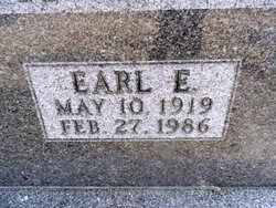
Earl Eugene Harold Stickfort
| Birth | : | 10 May 1919 Iowa, USA |
| Death | : | 27 Feb 1986 Iowa, USA |
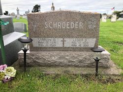
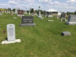
| Burial | : | Garnavillo Community Cemetery, Garnavillo, Clayton County, USA |
| Coordinate | : | 42.8656000, -91.2422100 |
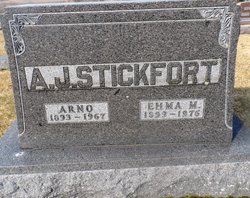
| Description | : | OBITUARY - Earl Eugene Harold, son of Mr. Arno Stickfort and his wife Emma Theodor Stickfort, was born on his parents farm in Garnavillo Township, Clayton County, Iowa, on May 10, 1919. He became a child of God through the Sacrament of Holy Baptism which was administered on July 6, 1919, by the Rev. K. Wm. Braun, pastor of The St. Paul Ev. Lutheran Church, Garnavillo, Iowa. He was confirmed in the Luterhan Christian Faith in the church of his baptism on Palm Sunday, March 25, 1934, by Pastor M. J. Harder. He remained a Communicant member... Read More |
frequently asked questions (FAQ):
-
Where is Earl Eugene Harold Stickfort's memorial?
Earl Eugene Harold Stickfort's memorial is located at: Garnavillo Community Cemetery, Garnavillo, Clayton County, USA.
-
When did Earl Eugene Harold Stickfort death?
Earl Eugene Harold Stickfort death on 27 Feb 1986 in Iowa, USA
-
Where are the coordinates of the Earl Eugene Harold Stickfort's memorial?
Latitude: 42.8656000
Longitude: -91.2422100
Family Members:
Parent

Spouse
Siblings


Children

Flowers:


Nearby Cemetories:
1. Garnavillo Community Cemetery
Garnavillo, Clayton County, USA
Coordinate: 42.8656000, -91.2422100
2. Garnavillo Cemetery
Garnavillo, Clayton County, USA
Coordinate: 42.8660300, -91.2390100
3. Saint Joseph Cemetery
Garnavillo, Clayton County, USA
Coordinate: 42.8628006, -91.2502975
4. McClelland Cemetery
Garnavillo, Clayton County, USA
Coordinate: 42.8249879, -91.2084641
5. Pioneer Rock Cemetery
Ceres, Clayton County, USA
Coordinate: 42.8230591, -91.1863937
6. Clayton Center Cemetery
Clayton Center, Clayton County, USA
Coordinate: 42.8841705, -91.3225021
7. Zion Lutheran Cemetery
Clayton Center, Clayton County, USA
Coordinate: 42.8841705, -91.3249969
8. Clayton Cemetery
Clayton, Clayton County, USA
Coordinate: 42.9043999, -91.1641998
9. Tangeman Family Cemetery
Garnavillo, Clayton County, USA
Coordinate: 42.8580000, -91.1420000
10. Saint Michael Cemetery
Clayton County, USA
Coordinate: 42.8055992, -91.1802979
11. County Home Cemetery
Clayton Center, Clayton County, USA
Coordinate: 42.8916702, -91.3499985
12. Krumm Cemetery
Garber, Clayton County, USA
Coordinate: 42.7913760, -91.3023559
13. Colony Catholic Cemetery (Defunct)
Read Township, Clayton County, USA
Coordinate: 42.8830000, -91.3580000
14. Borcherding Cemetery
Jefferson Township, Clayton County, USA
Coordinate: 42.8182983, -91.1414032
15. National Cemetery
National, Clayton County, USA
Coordinate: 42.9536018, -91.2902985
16. Storck Cemetery
Guttenberg, Clayton County, USA
Coordinate: 42.7694335, -91.1834638
17. Harford Cemetery
Wyalusing, Grant County, USA
Coordinate: 42.9401000, -91.1401800
18. Saint Paula Cemetery
Osterdock, Clayton County, USA
Coordinate: 42.7635994, -91.1992035
19. Meenan Cemetery
Communia, Clayton County, USA
Coordinate: 42.7999862, -91.3584693
20. Norwegian Church Cemetery
McGregor, Clayton County, USA
Coordinate: 42.9644400, -91.1764100
21. Old Garber Cemetery
Garber, Clayton County, USA
Coordinate: 42.7560005, -91.2580032
22. Elkader Cemetery
Elkader, Clayton County, USA
Coordinate: 42.8541718, -91.4000015
23. Bagley Cemetery
Bagley, Grant County, USA
Coordinate: 42.9019012, -91.0907974
24. First Evangelical Lutheran Church Cemetery
McGregor, Clayton County, USA
Coordinate: 42.9718000, -91.1760000