


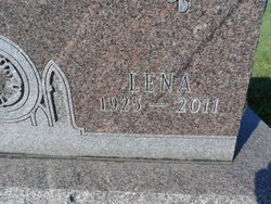
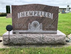
Lena Emma Christina Stickfort Hempeler
| Birth | : | 25 Jan 1925 Garnavillo, Clayton County, Iowa, USA |
| Death | : | 12 Nov 2011 Guttenberg, Clayton County, Iowa, USA |
| Burial | : | Garnavillo Community Cemetery, Garnavillo, Clayton County, USA |
| Coordinate | : | 42.8656000, -91.2422100 |
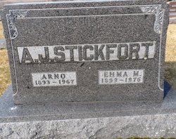
| Description | : | Daughter of Arnold & Emma Theodore Stickfort Lena E. Hempeler, 86, died November 12, 2011, of natural causes, at the Guttenberg Hospital, Guttenberg, IA. Lena Emma Christina Stickfort Hempeler was born January 25, 1925, the daughter of Arnold and Emma (Theodore) Stickfort in Garnavillo, IA. She was baptized April 6, 1925 in St. Paul's Lutheran Church, Garnavillo, IA. Lena grew up on a farm outside of Garnavillo, graduating from Garnavillo High School, 1942. She married Arlyn A. Hempeler September 4, 1943 at St. John's Lutheran Church, Independence, IA. They operated Rolling Prairie Guernsey Farm until 1983, when they retired to Garnavillo. Lena took... Read More |
frequently asked questions (FAQ):
-
Where is Lena Emma Christina Stickfort Hempeler's memorial?
Lena Emma Christina Stickfort Hempeler's memorial is located at: Garnavillo Community Cemetery, Garnavillo, Clayton County, USA.
-
When did Lena Emma Christina Stickfort Hempeler death?
Lena Emma Christina Stickfort Hempeler death on 12 Nov 2011 in Guttenberg, Clayton County, Iowa, USA
-
Where are the coordinates of the Lena Emma Christina Stickfort Hempeler's memorial?
Latitude: 42.8656000
Longitude: -91.2422100
Family Members:
Parent

Spouse
Siblings


Children
Flowers:


Nearby Cemetories:
1. Garnavillo Community Cemetery
Garnavillo, Clayton County, USA
Coordinate: 42.8656000, -91.2422100
2. Garnavillo Cemetery
Garnavillo, Clayton County, USA
Coordinate: 42.8660300, -91.2390100
3. Saint Joseph Cemetery
Garnavillo, Clayton County, USA
Coordinate: 42.8628006, -91.2502975
4. McClelland Cemetery
Garnavillo, Clayton County, USA
Coordinate: 42.8249879, -91.2084641
5. Pioneer Rock Cemetery
Ceres, Clayton County, USA
Coordinate: 42.8230591, -91.1863937
6. Clayton Center Cemetery
Clayton Center, Clayton County, USA
Coordinate: 42.8841705, -91.3225021
7. Zion Lutheran Cemetery
Clayton Center, Clayton County, USA
Coordinate: 42.8841705, -91.3249969
8. Clayton Cemetery
Clayton, Clayton County, USA
Coordinate: 42.9043999, -91.1641998
9. Tangeman Family Cemetery
Garnavillo, Clayton County, USA
Coordinate: 42.8580000, -91.1420000
10. Saint Michael Cemetery
Clayton County, USA
Coordinate: 42.8055992, -91.1802979
11. County Home Cemetery
Clayton Center, Clayton County, USA
Coordinate: 42.8916702, -91.3499985
12. Krumm Cemetery
Garber, Clayton County, USA
Coordinate: 42.7913760, -91.3023559
13. Colony Catholic Cemetery (Defunct)
Read Township, Clayton County, USA
Coordinate: 42.8830000, -91.3580000
14. Borcherding Cemetery
Jefferson Township, Clayton County, USA
Coordinate: 42.8182983, -91.1414032
15. National Cemetery
National, Clayton County, USA
Coordinate: 42.9536018, -91.2902985
16. Storck Cemetery
Guttenberg, Clayton County, USA
Coordinate: 42.7694335, -91.1834638
17. Harford Cemetery
Wyalusing, Grant County, USA
Coordinate: 42.9401000, -91.1401800
18. Saint Paula Cemetery
Osterdock, Clayton County, USA
Coordinate: 42.7635994, -91.1992035
19. Meenan Cemetery
Communia, Clayton County, USA
Coordinate: 42.7999862, -91.3584693
20. Norwegian Church Cemetery
McGregor, Clayton County, USA
Coordinate: 42.9644400, -91.1764100
21. Old Garber Cemetery
Garber, Clayton County, USA
Coordinate: 42.7560005, -91.2580032
22. Elkader Cemetery
Elkader, Clayton County, USA
Coordinate: 42.8541718, -91.4000015
23. Bagley Cemetery
Bagley, Grant County, USA
Coordinate: 42.9019012, -91.0907974
24. First Evangelical Lutheran Church Cemetery
McGregor, Clayton County, USA
Coordinate: 42.9718000, -91.1760000