
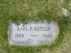
Earl Perry Butler
| Birth | : | 18 Oct 1892 Warren County, Iowa, USA |
| Death | : | 28 Feb 1946 Havre, Hill County, Montana, USA |
| Burial | : | Highland Cemetery, Havre, Hill County, USA |
| Coordinate | : | 48.5463982, -109.6900024 |
| Plot | : | Space E Lot 7 Block 12 |
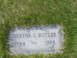
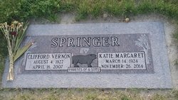
| Description | : | 12/15/2021: Suggested edit: Havre Daily News (MT), 1 March 1946 Earl P. Butler Dies at Ranch West of Havre Earl P. Butler, 53, rancher who resided 36 miles northwest of Havre, died early last night following a heart attack. Mr. Butler's wife, the former Bertha Latimore, passed away Oct. 29, 1929. The deceased was born in Indianola, Iowa, Oct. 15, 1892. He came to Montana in 1916. Survivors are two sons, Edwin of Havre and Leslie of Lovonia, Mo.; and four daughters, Mrs. Andrew Server of Des Moines, Iowa, Mrs. Clifford Springer of Havre, and Hazel Butler and Lettie Butler... Read More |
frequently asked questions (FAQ):
-
Where is Earl Perry Butler's memorial?
Earl Perry Butler's memorial is located at: Highland Cemetery, Havre, Hill County, USA.
-
When did Earl Perry Butler death?
Earl Perry Butler death on 28 Feb 1946 in Havre, Hill County, Montana, USA
-
Where are the coordinates of the Earl Perry Butler's memorial?
Latitude: 48.5463982
Longitude: -109.6900024
Family Members:
Spouse
Children
Flowers:


Nearby Cemetories:
1. Highland Cemetery
Havre, Hill County, USA
Coordinate: 48.5463982, -109.6900024
2. Calvary Cemetery
Havre, Hill County, USA
Coordinate: 48.5457000, -109.6883000
3. Mount Hope Cemetery
Havre, Hill County, USA
Coordinate: 48.5540000, -109.7050000
4. Sunset Garden Park
Havre, Hill County, USA
Coordinate: 48.5531006, -109.8019028
5. North Havre Lutheran Church Graveyard (Defunct)
Havre, Hill County, USA
Coordinate: 48.6538903, -109.6815870
6. Grainbelt Cemetery
Hill County, USA
Coordinate: 48.6828003, -109.8657990
7. Andrew S. Lohman Grave Site
Lohman, Blaine County, USA
Coordinate: 48.5903520, -109.4073350
8. East End Colony Cemetery
East End Colony, Hill County, USA
Coordinate: 48.7485000, -109.5474000
9. Hilldale Hutterite Colony Cemetery
Hilldale Colony, Hill County, USA
Coordinate: 48.7997000, -109.7872000
10. Saint Johns Catholic Cemetery
Havre, Hill County, USA
Coordinate: 48.7625008, -109.9638977
11. Saint Gabriel Cemetery
Chinook, Blaine County, USA
Coordinate: 48.6065200, -109.2531200
12. Kuper Memorial Cemetery
Chinook, Blaine County, USA
Coordinate: 48.6083100, -109.2531200
13. Rocky Boy Cemetery
Rocky Boy, Hill County, USA
Coordinate: 48.2572410, -109.7923690
14. Box Elder Cemetery
Box Elder, Hill County, USA
Coordinate: 48.3274000, -110.0095000
15. Rocky Boy Gravel Cemetery
Rocky Boy, Hill County, USA
Coordinate: 48.2427720, -109.7596500
16. Cottonwood Lutheran Church Cemetery
Havre, Hill County, USA
Coordinate: 48.4545000, -110.1748000
17. Bear Paw Battlefield
Chinook, Blaine County, USA
Coordinate: 48.3780070, -109.2121290
18. Hungry Hollow Cemetery
Blaine County, USA
Coordinate: 48.2103004, -109.4677963
19. Milk River Valley Church Graveyard
Hill County, USA
Coordinate: 48.6787180, -110.2261080
20. Hollandville Cemetery
Chinook, Blaine County, USA
Coordinate: 48.6960310, -109.1557200
21. Gildford Hill County Cemetery
Gildford, Hill County, USA
Coordinate: 48.5778008, -110.2957993
22. Prairie Chapel United Brethren Cemetery
Chinook, Blaine County, USA
Coordinate: 48.8860000, -109.3414000
23. Mennonite Brethren Cemetery
Chinook, Blaine County, USA
Coordinate: 48.8012560, -109.1980620
24. Bethel Bruderthaler Mennonite Church Cemetery
Chinook, Blaine County, USA
Coordinate: 48.7552000, -109.1345000