
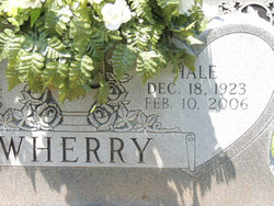

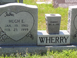
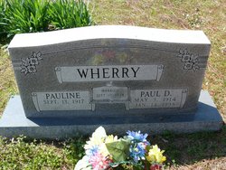
Edgar Hale Wherry
| Birth | : | 18 Dec 1923 Independence County, Arkansas, USA |
| Death | : | 10 Feb 2006 Newark, Independence County, Arkansas, USA |
| Burial | : | Evangelical Cemetery, Nerstrand, Rice County, USA |
| Coordinate | : | 44.3269005, -93.0419006 |
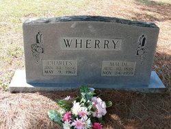
| Description | : | Bates ville Daily Guard Edgar Wherry Published Monday February 13, 2006 NEWARK — Edgar Hale Wherry, 82, of Newark died Friday, Feb. 10, 2006, in Batesville. Born Dec. 18, 1923, at Logan Township, he was the son of Charlie and Maude Wherry. He was a U.S. Navy veteran, having served in World War II, and was a member of the American Legion. He retired from Arkla Gas Company in 1985 and enjoyed fishing and hunting. He was a member of Newark Church of Christ. Survivors include his wife, Ermalee Wherry; a son, John Wherry of Louisville, Ky.; three daughters, Wanda Wilson and... Read More |
frequently asked questions (FAQ):
-
Where is Edgar Hale Wherry's memorial?
Edgar Hale Wherry's memorial is located at: Evangelical Cemetery, Nerstrand, Rice County, USA.
-
When did Edgar Hale Wherry death?
Edgar Hale Wherry death on 10 Feb 2006 in Newark, Independence County, Arkansas, USA
-
Where are the coordinates of the Edgar Hale Wherry's memorial?
Latitude: 44.3269005
Longitude: -93.0419006
Family Members:
Parent

Spouse
Siblings
Flowers:


Nearby Cemetories:
1. Evangelical Cemetery
Nerstrand, Rice County, USA
Coordinate: 44.3269005, -93.0419006
2. Knoll Cemetery
Goodhue County, USA
Coordinate: 44.3269005, -93.0252991
3. Nerstrand Cemetery
Nerstrand, Rice County, USA
Coordinate: 44.3493996, -93.0658035
4. Vang Lutheran Church Cemetery
Dennison, Goodhue County, USA
Coordinate: 44.3566895, -92.9994812
5. Little Cannon Cemetery
Dennison, Goodhue County, USA
Coordinate: 44.3272209, -92.9805603
6. Saint Johns United Church of Christ Cemetery
Faribault, Rice County, USA
Coordinate: 44.3120728, -93.1027679
7. Valley Grove Cemetery
Nerstrand, Rice County, USA
Coordinate: 44.3619000, -93.1011000
8. Saint Michaels Cemetery
Kenyon, Goodhue County, USA
Coordinate: 44.2980995, -92.9700012
9. Gol Lutheran Church Cemetery
Kenyon, Goodhue County, USA
Coordinate: 44.2713318, -93.0106964
10. Old Hauge Cemetery
Kenyon, Goodhue County, USA
Coordinate: 44.3706700, -92.9751800
11. Epsom Pioneer Cemetery
Epsom, Rice County, USA
Coordinate: 44.2610730, -93.0558130
12. Kenyon Cemetery
Kenyon, Goodhue County, USA
Coordinate: 44.2762299, -92.9813995
13. Prairieville United Methodist Cemetery
Faribault, Rice County, USA
Coordinate: 44.2833786, -93.1132278
14. Hauge Cemetery
Kenyon, Goodhue County, USA
Coordinate: 44.2555618, -93.0213928
15. Prairie Creek Cemetery
Northfield, Rice County, USA
Coordinate: 44.4072000, -93.0966000
16. Saint Edwards Catholic Cemetery
Epsom, Rice County, USA
Coordinate: 44.2413010, -93.1164130
17. Holden Lutheran Cemetery
Kenyon, Goodhue County, USA
Coordinate: 44.3203926, -92.8936081
18. Old Prairieville Cemetery
Prairieville, Rice County, USA
Coordinate: 44.2841680, -93.1903270
19. Richland Union Cemetery
Faribault, Rice County, USA
Coordinate: 44.2405340, -93.1567680
20. Eidsvold Cemetery
Goodhue County, USA
Coordinate: 44.3774986, -92.8905563
21. Cannon City Cemetery
Cannon City, Rice County, USA
Coordinate: 44.3232040, -93.2098083
22. Greenwood Cemetery
Faribault, Rice County, USA
Coordinate: 44.2116600, -93.0913600
23. Emmanuel Lutheran Cemetery Aspelund
Wanamingo, Goodhue County, USA
Coordinate: 44.3274994, -92.8713913
24. Urland Cemetery
Sogn, Goodhue County, USA
Coordinate: 44.3986092, -92.8925018