
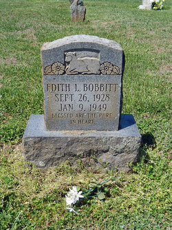
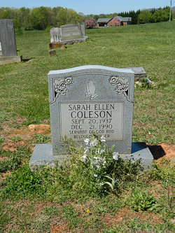
Edith Loraine Coalson Bobbitt
| Birth | : | 26 Sep 1927 Surry County, North Carolina, USA |
| Death | : | 9 Jan 1949 Mount Airy, Surry County, North Carolina, USA |
| Burial | : | Golding Family Cemetery, Mount Airy, Surry County, USA |
| Coordinate | : | 36.5326670, -80.7528330 |
| Description | : | Name: Edith Loraine Bobbitt Death Date: 09 Jan 1949 Death Place: Mt Airy Burial Date: 10 Jan 1949 Burial Place: Low Gap, N.C. Cemetery: Old Golding Residence: Low Gap, Surry, Nor. Car. Street Address: R. 1 Gender: Female Death Age: 21 Marital Status: Married Race: White Birth Date: 26 Aug 1927 Birthplace: Surry, N.C. Father: Frank Coalson Father's Place of Birth: Surry, N.C. Mother: Mary Bobbitt Mother's Place of Birth: Grayson, Va. Spouse: Ralph Bobbitt |
frequently asked questions (FAQ):
-
Where is Edith Loraine Coalson Bobbitt's memorial?
Edith Loraine Coalson Bobbitt's memorial is located at: Golding Family Cemetery, Mount Airy, Surry County, USA.
-
When did Edith Loraine Coalson Bobbitt death?
Edith Loraine Coalson Bobbitt death on 9 Jan 1949 in Mount Airy, Surry County, North Carolina, USA
-
Where are the coordinates of the Edith Loraine Coalson Bobbitt's memorial?
Latitude: 36.5326670
Longitude: -80.7528330
Family Members:
Parent

Spouse

Siblings
Flowers:


Nearby Cemetories:
1. Golding Family Cemetery
Mount Airy, Surry County, USA
Coordinate: 36.5326670, -80.7528330
2. Zion Hill Primitive Baptist Church Cemetery
Crooked Oak, Surry County, USA
Coordinate: 36.5313339, -80.7572250
3. Johnson Puckett Cemetery
Mount Airy, Surry County, USA
Coordinate: 36.5306740, -80.7362830
4. Furbee Cemetery
Wetzel County, USA
Coordinate: 36.5363984, -80.7316687
5. Ivy Green Baptist Church Cemetery
Crooked Oak, Surry County, USA
Coordinate: 36.5381927, -80.7771683
6. Snow Cemetery
Mount Airy, Surry County, USA
Coordinate: 36.5422500, -80.7299170
7. Jarrell Family Graveyard
Lowgap, Surry County, USA
Coordinate: 36.5362520, -80.7798310
8. Blue Ridge Baptist Church Cemetery
Crooked Oak, Surry County, USA
Coordinate: 36.5490440, -80.7727400
9. Holder Cemetery
Lowgap, Surry County, USA
Coordinate: 36.5364670, -80.7875720
10. Maple Grove United Methodist Church Cemetery
Pine Ridge, Surry County, USA
Coordinate: 36.5237770, -80.7171402
11. Phillip Haywood McBride Family Cemetery
Lowgap, Surry County, USA
Coordinate: 36.5602950, -80.7678630
12. Round Peak Primitive Baptist Church Cemetery
Round Peak, Surry County, USA
Coordinate: 36.5145264, -80.7861633
13. Imogene Baptist Church Cemetery
Pine Ridge, Surry County, USA
Coordinate: 36.5521393, -80.7203598
14. Low Family Cemetery
Lowgap, Surry County, USA
Coordinate: 36.5461430, -80.7985910
15. Semper Fi Cemetery
Pine Ridge, Surry County, USA
Coordinate: 36.5010540, -80.7216920
16. Beamer Cemetery
Mount Airy, Surry County, USA
Coordinate: 36.5343060, -80.7012220
17. Dillard Family Cemetery
Lowgap, Surry County, USA
Coordinate: 36.5500298, -80.8002243
18. Pine Ridge Baptist Church Cemetery
Pine Ridge, Surry County, USA
Coordinate: 36.4995842, -80.7190552
19. Moore Family Cemetery
Mount Airy, Surry County, USA
Coordinate: 36.4919910, -80.7741450
20. Stewart Cemetery
Lambsburg, Carroll County, USA
Coordinate: 36.5681860, -80.7855490
21. Holly Grove Baptist Church Cemetery
Lambsburg, Carroll County, USA
Coordinate: 36.5712840, -80.7810790
22. James Harding Golding Family Cemetery
Mount Airy, Surry County, USA
Coordinate: 36.5539500, -80.7023900
23. New Bethel Baptist Church Cemetery
Mount Airy, Surry County, USA
Coordinate: 36.5535920, -80.7020960
24. New Bethel Baptist South
Mount Airy, Surry County, USA
Coordinate: 36.5533870, -80.7018270