
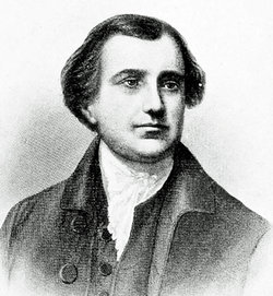

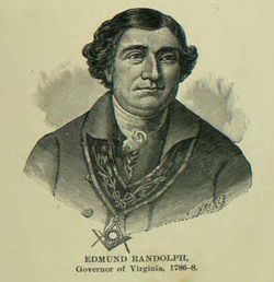
Edmund Jennings Randolph Famous memorial
| Birth | : | 10 Aug 1753 Williamsburg, Williamsburg City, Virginia, USA |
| Death | : | 13 Sep 1813 Millwood, Clarke County, Virginia, USA |
| Burial | : | St. Andrew Churchyard, Fairlight, Rother District, England |
| Coordinate | : | 50.8769080, 0.6424300 |
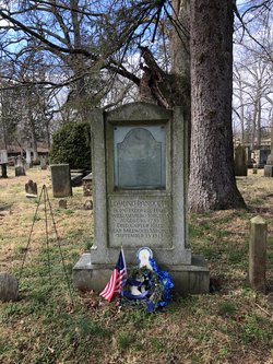
| Inscription | : | Edmund Randolph born Tazewell Hall, Williamsburg, Virginia August 10, 1753 died Carter Hall near Millwood, Virginia September 13, 1813 |
| Description | : | Presidential Cabinet Secretary, 7th Virginia Governor. Edmund was born at Tazewell Hall in the colonial town of Williamsburg, Virginia to the prominent Randolph family and went to William and Mary College there. After graduation he studied law under his father, John Randolph, and uncle, Peyton Randolph. At the start of the Revolutionary War his father, a loyalist, returned to England while Edmund joined the Continental Army as aide-de-camp to George Washington. In October 1775 Edmund would return to Williamsburg to act as executor of his uncle's estate and was elected as a representative to the Virginia Convention while attending to... Read More |
frequently asked questions (FAQ):
-
Where is Edmund Jennings Randolph Famous memorial's memorial?
Edmund Jennings Randolph Famous memorial's memorial is located at: St. Andrew Churchyard, Fairlight, Rother District, England.
-
When did Edmund Jennings Randolph Famous memorial death?
Edmund Jennings Randolph Famous memorial death on 13 Sep 1813 in Millwood, Clarke County, Virginia, USA
-
Where are the coordinates of the Edmund Jennings Randolph Famous memorial's memorial?
Latitude: 50.8769080
Longitude: 0.6424300
Family Members:
Parent
Spouse
Siblings
Children

Flowers:


Nearby Cemetories:
1. St. Andrew Churchyard
Fairlight, Rother District, England
Coordinate: 50.8769080, 0.6424300
2. Fairlight Catholic Cemetery
Fairlight, Rother District, England
Coordinate: 50.8763470, 0.6428020
3. Pett Methodist Chapel
Pett, Rother District, England
Coordinate: 50.8948184, 0.6606219
4. Saints Mary and Peter Churchyard
Pett, Rother District, England
Coordinate: 50.8944100, 0.6616400
5. St Laurence Churchyard
Guestling, Rother District, England
Coordinate: 50.8996239, 0.6366920
6. Hastings Cemetery and Crematorium
Hastings, Hastings Borough, England
Coordinate: 50.8805070, 0.5904080
7. All Saints Churchyard
Hastings, Hastings Borough, England
Coordinate: 50.8593840, 0.5961820
8. St Mary-in-the-Castle
Hastings, Hastings Borough, England
Coordinate: 50.8555490, 0.5846370
9. All Saints and St Nicholas Churchyard
Icklesham, Rother District, England
Coordinate: 50.9171000, 0.6739770
10. St John the Baptist Churchyard
Westfield, Rother District, England
Coordinate: 50.9080090, 0.5729280
11. St. Leonard's Churchyard
St Leonards, Hastings Borough, England
Coordinate: 50.8513100, 0.5514400
12. Saint Mary Churchyard
Udimore, Rother District, England
Coordinate: 50.9399770, 0.6508420
13. Winchelsea Churchyard
Winchelsea, Rother District, England
Coordinate: 50.9241920, 0.7091480
14. St George Churchyard
Brede, Rother District, England
Coordinate: 50.9349140, 0.5963830
15. St. Leonard Churchyard
Hollington, Hastings Borough, England
Coordinate: 50.8743230, 0.5379840
16. BroadOak Methodist Chapel
Brede, Rother District, England
Coordinate: 50.9487320, 0.6015820
17. Saint Peter & Saint Paul Church Churchyard
Peasmarsh, Rother District, England
Coordinate: 50.9645500, 0.6859200
18. Crowhurst Churchyard
Crowhurst, Rother District, England
Coordinate: 50.8838070, 0.4968630
19. St Theresa's Catholic Church
Northiam, Rother District, England
Coordinate: 50.9654510, 0.5958960
20. St Mary the Virgin Churchyard
Rye, Rother District, England
Coordinate: 50.9501686, 0.7341530
21. Holy Spirit Churchyard
Rye Harbour, Rother District, England
Coordinate: 50.9387970, 0.7567050
22. St. John Baptist Anglcian Churchyard
Sedlescombe, Rother District, England
Coordinate: 50.9412440, 0.5281560
23. Rye Cemetery
Rye, Rother District, England
Coordinate: 50.9595370, 0.7322520
24. Battle Cemetery
Battle, Rother District, England
Coordinate: 50.9155800, 0.4935500