

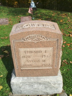
Edward Erving Bowers
| Birth | : | 19 Jun 1878 Coshocton County, Ohio, USA |
| Death | : | 1942 |
| Burial | : | Darling Run Cemetery, Nellie, Coshocton County, USA |
| Coordinate | : | 40.3436012, -82.0505981 |
| Description | : | children include: Myrtle L Bowers b: abt. 1901 Russell Bowers b: 1905 Mary Bowers b: abt 1908 Walter Bowers b. abt 1912 Elsie Bowers b. abt 1914 |
frequently asked questions (FAQ):
-
Where is Edward Erving Bowers's memorial?
Edward Erving Bowers's memorial is located at: Darling Run Cemetery, Nellie, Coshocton County, USA.
-
When did Edward Erving Bowers death?
Edward Erving Bowers death on 1942 in
-
Where are the coordinates of the Edward Erving Bowers's memorial?
Latitude: 40.3436012
Longitude: -82.0505981
Family Members:
Spouse
Children
Flowers:


Nearby Cemetories:
1. Darling Run Cemetery
Nellie, Coshocton County, USA
Coordinate: 40.3436012, -82.0505981
2. Butler East Cemetery
Nellie, Coshocton County, USA
Coordinate: 40.3514580, -82.0818970
3. Mohawk Methodist Church Cemetery
Mohawk Village, Coshocton County, USA
Coordinate: 40.3182290, -82.0724610
4. Bethel Cemetery
Warsaw, Coshocton County, USA
Coordinate: 40.3615800, -82.0165150
5. Valley View Cemetery
Warsaw, Coshocton County, USA
Coordinate: 40.3255997, -82.0139008
6. Jefferson Presbyterian Cemetery
Warsaw, Coshocton County, USA
Coordinate: 40.3200690, -82.0165291
7. Butler West Cemetery
Nellie, Coshocton County, USA
Coordinate: 40.3523620, -82.0961490
8. Bateman Cemetery
Warsaw, Coshocton County, USA
Coordinate: 40.3483840, -81.9876370
9. Saint Elizabeth Mission Cemetery
Spring Mountain, Coshocton County, USA
Coordinate: 40.3817900, -82.0108300
10. Honey Run Cemetery
Walhonding, Coshocton County, USA
Coordinate: 40.3711014, -82.1175003
11. Christian Church Cemetery
Warsaw, Coshocton County, USA
Coordinate: 40.3250000, -82.1230000
12. Antioch Cemetery
Coshocton County, USA
Coordinate: 40.3046989, -81.9933014
13. Weatherwax Cemetery
Clark, Coshocton County, USA
Coordinate: 40.3839560, -81.9918080
14. Spring Mountain Cemetery
Spring Mountain, Coshocton County, USA
Coordinate: 40.4053800, -82.0439000
15. Bucklew Cemetery
Metham, Coshocton County, USA
Coordinate: 40.3849983, -81.9858017
16. McKee Cemetery
Walhonding, Coshocton County, USA
Coordinate: 40.3817123, -82.1190115
17. Mikesell Cemetery
West Bedford, Coshocton County, USA
Coordinate: 40.2882500, -82.0963240
18. Blooming Grove Cemetery
Randle, Coshocton County, USA
Coordinate: 40.3017006, -81.9843979
19. Mohawk Baptist Church Cemetery
Nellie, Coshocton County, USA
Coordinate: 40.2941380, -82.1107120
20. Wilson Chapel Cemetery
Nellie, Coshocton County, USA
Coordinate: 40.3017690, -82.1207660
21. Walhonding Cemetery
Walhonding, Coshocton County, USA
Coordinate: 40.3627800, -82.1411700
22. Dutch Run Cemetery
Tiverton Township, Coshocton County, USA
Coordinate: 40.4021988, -82.1072006
23. Mount Zion Methodist Church Cemetery
Metham, Coshocton County, USA
Coordinate: 40.3559580, -81.9522140
24. Blissfield Cemetery
Blissfield, Coshocton County, USA
Coordinate: 40.3927994, -81.9728012