
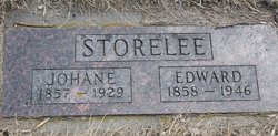
Edward O. Storelee
| Birth | : | 14 Jul 1858 |
| Death | : | 24 Jan 1946 Ransom County, North Dakota, USA |
| Burial | : | St Mary the Virgin Churchyard, Wheatley, South Oxfordshire District, England |
| Coordinate | : | 51.7476020, -1.1366080 |
frequently asked questions (FAQ):
-
Where is Edward O. Storelee's memorial?
Edward O. Storelee's memorial is located at: St Mary the Virgin Churchyard, Wheatley, South Oxfordshire District, England.
-
When did Edward O. Storelee death?
Edward O. Storelee death on 24 Jan 1946 in Ransom County, North Dakota, USA
-
Where are the coordinates of the Edward O. Storelee's memorial?
Latitude: 51.7476020
Longitude: -1.1366080
Family Members:
Parent
Spouse

Siblings
Children
Flowers:


Nearby Cemetories:
1. St Mary the Virgin Churchyard
Wheatley, South Oxfordshire District, England
Coordinate: 51.7476020, -1.1366080
2. Wheatley War Memorial
Wheatley, South Oxfordshire District, England
Coordinate: 51.7468630, -1.1388780
3. St Bartholomew Churchyard
Holton, South Oxfordshire District, England
Coordinate: 51.7529490, -1.1246510
4. St. Nicholas' Church
Forest Hill, South Oxfordshire District, England
Coordinate: 51.7641400, -1.1567200
5. Forest Hill Church Cemetery
Forest Hill, South Oxfordshire District, England
Coordinate: 51.7641700, -1.1567100
6. St. Giles' Churchyard
Horspath, South Oxfordshire District, England
Coordinate: 51.7397190, -1.1738770
7. All Saints Churchyard
Cuddesdon, South Oxfordshire District, England
Coordinate: 51.7230140, -1.1316130
8. St Mary's Churchyard
Waterperry, South Oxfordshire District, England
Coordinate: 51.7521000, -1.0894000
9. Saint Leonard's Churchyard
Waterstock, South Oxfordshire District, England
Coordinate: 51.7451800, -1.0807500
10. Saint Mary's Churchyard
Garsington, South Oxfordshire District, England
Coordinate: 51.7140100, -1.1600700
11. Saint John the Baptist
Stanton St John, South Oxfordshire District, England
Coordinate: 51.7800350, -1.1642830
12. Holy Trinity Churchyard
Headington, City of Oxford, England
Coordinate: 51.7577500, -1.1979980
13. Cornerstone Church Cemetery
Headington, City of Oxford, England
Coordinate: 51.7587275, -1.1995588
14. St Mary the Virgin Churchyard
Great Milton, South Oxfordshire District, England
Coordinate: 51.7170320, -1.0921100
15. Oxford Crematorium
Headington, City of Oxford, England
Coordinate: 51.7719240, -1.1904020
16. St. Nicholas' Churchyard
Ickford, Aylesbury Vale District, England
Coordinate: 51.7614648, -1.0656459
17. St. Aldate's Churchyard
Oxford, City of Oxford, England
Coordinate: 51.7497900, -1.2118500
18. St Lawrence Churchyard
Toot Baldon, South Oxfordshire District, England
Coordinate: 51.7051720, -1.1750220
19. The Priory
Headington, City of Oxford, England
Coordinate: 51.7638260, -1.2108100
20. St James Churchyard
Little Milton, South Oxfordshire District, England
Coordinate: 51.7019280, -1.1072800
21. St Andrew Churchyard
Headington, City of Oxford, England
Coordinate: 51.7647100, -1.2121400
22. St Helen Churchyard
Albury, South Oxfordshire District, England
Coordinate: 51.7406280, -1.0519520
23. Headington Cemetery
Headington, City of Oxford, England
Coordinate: 51.7668050, -1.2179280
24. St. James Churchyard
Cowley, City of Oxford, England
Coordinate: 51.7305878, -1.2202638