

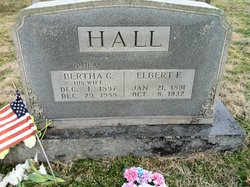
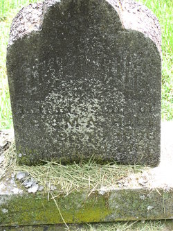
Elbert F. Hall
| Birth | : | 21 Jan 1891 USA |
| Death | : | 6 Oct 1932 Missouri, USA |
| Burial | : | Pond Creek Cemetery, Pond Creek, Grant County, USA |
| Coordinate | : | 36.6521988, -97.7936020 |
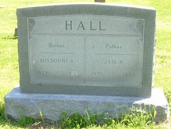
| Description | : | Son of James Raburn Hall and Missouri Ann Woodard; married Bertha G. Kinsley. |
frequently asked questions (FAQ):
-
Where is Elbert F. Hall's memorial?
Elbert F. Hall's memorial is located at: Pond Creek Cemetery, Pond Creek, Grant County, USA.
-
When did Elbert F. Hall death?
Elbert F. Hall death on 6 Oct 1932 in Missouri, USA
-
Where are the coordinates of the Elbert F. Hall's memorial?
Latitude: 36.6521988
Longitude: -97.7936020
Family Members:
Parent

Spouse
Siblings


Nearby Cemetories:
1. Pond Creek Cemetery
Pond Creek, Grant County, USA
Coordinate: 36.6521988, -97.7936020
2. Valley Center Cemetery
Pond Creek, Grant County, USA
Coordinate: 36.6081009, -97.8281021
3. Old Pond Creek Ranch Cowboy Burials
Pond Creek, Grant County, USA
Coordinate: 36.7086920, -97.7909950
4. Greenwood Cemetery
Pond Creek, Grant County, USA
Coordinate: 36.6366600, -97.7054000
5. Smith Cemetery
Jefferson, Grant County, USA
Coordinate: 36.7088800, -97.7139000
6. Liberty Cemetery
Grant County, USA
Coordinate: 36.7235985, -97.7149963
7. Kremlin Cemetery
Kremlin, Garfield County, USA
Coordinate: 36.5494003, -97.8131027
8. Mount Zion Cemetery
Nash, Grant County, USA
Coordinate: 36.6594009, -97.9285965
9. Klondike Cemetery
Grant County, USA
Coordinate: 36.7592010, -97.8566971
10. White Cemetery
Hunter, Garfield County, USA
Coordinate: 36.5788994, -97.6660995
11. Fairview Cemetery
Grant County, USA
Coordinate: 36.7813988, -97.8139038
12. Mount Pleasant Cemetery
Salt Fork, Grant County, USA
Coordinate: 36.6217003, -97.6333008
13. Coldwater Cemetery
Grant County, USA
Coordinate: 36.6956900, -97.9571500
14. Pleasant Hill Cemetery
Medford, Grant County, USA
Coordinate: 36.7742900, -97.9130000
15. Hillsdale Cemetery
Hillsdale, Garfield County, USA
Coordinate: 36.5652800, -97.9701700
16. Rosemound Cemetery
Medford, Grant County, USA
Coordinate: 36.8044014, -97.7039032
17. Lamont Cemetery
Lamont, Grant County, USA
Coordinate: 36.6967010, -97.5792007
18. Chisholm Trail Burial Park
Enid, Garfield County, USA
Coordinate: 36.4632500, -97.7921900
19. Breckinridge Lutheran Cemetery
Breckinridge, Garfield County, USA
Coordinate: 36.4632988, -97.7474976
20. Mennonite Brethren Cemetery
Enid, Garfield County, USA
Coordinate: 36.4637900, -97.8605300
21. Saint Anthony Cemetery
Clyde, Grant County, USA
Coordinate: 36.8478012, -97.8193970
22. Memorial Park Cemetery
Enid, Garfield County, USA
Coordinate: 36.4585991, -97.8685989
23. Medford Mennonite Cemetery
Medford, Grant County, USA
Coordinate: 36.8403000, -97.6968000
24. Saint Mary Calvary Cemetery
Medford, Grant County, USA
Coordinate: 36.8471985, -97.7061005