
Eleanor Slicer Hoye
| Birth | : | 1769 Frederick County, Maryland, USA |
| Death | : | 20 Jul 1812 Allegany County, Maryland, USA |
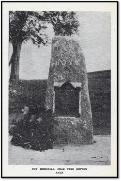
| Burial | : | Hoye Family Cemetery - Crab Tree Bottom, McHenry, Garrett County, USA |
| Coordinate | : | 39.5642220, -79.3855000 |
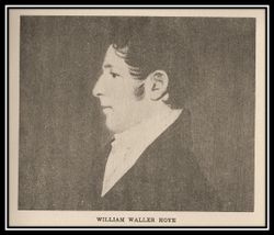
| Description | : | ELEANOR "ELLEN" SLICER HOYE 1769-1812 Daughter of James Slicer (1751-1808) and Mary Fornwalt Slicer (1754-1824) BIRTH: 1769 Frederick County, Maryland Colony DEATH: 20 Jul 1812 Crab Tree Bottom Farm Sang Run, Allegany County (now Garrett), Maryland BURIAL: 22 Jul 1812 Hoye Cemetery Crab Tree Bottom Married William Waller Hoye (1768-1836) 20 May 1796 in Cumberland Maryland, Rev. William Shaw officiating. Of this union, nine children, three of which died in infancy, including a son named Paul who is believed to be the first born and the first to be buried... Read More |
frequently asked questions (FAQ):
-
Where is Eleanor Slicer Hoye's memorial?
Eleanor Slicer Hoye's memorial is located at: Hoye Family Cemetery - Crab Tree Bottom, McHenry, Garrett County, USA.
-
When did Eleanor Slicer Hoye death?
Eleanor Slicer Hoye death on 20 Jul 1812 in Allegany County, Maryland, USA
-
Where are the coordinates of the Eleanor Slicer Hoye's memorial?
Latitude: 39.5642220
Longitude: -79.3855000
Family Members:
Spouse
Children


Flowers:


Nearby Cemetories:
1. Hoye Family Cemetery - Crab Tree Bottom
McHenry, Garrett County, USA
Coordinate: 39.5642220, -79.3855000
2. Oak Grove Church of the Brethren Cemetery
McHenry, Garrett County, USA
Coordinate: 39.5694400, -79.3834300
3. Saint Dominic Catholic Cemetery
Hoyes, Garrett County, USA
Coordinate: 39.5868300, -79.3698600
4. Hoyes Cemetery
Garrett County, USA
Coordinate: 39.5905991, -79.3683014
5. Upper Sang Run Cemetery
McHenry, Garrett County, USA
Coordinate: 39.5717810, -79.4242430
6. Hoyes Run Cemetery
Garrett County, USA
Coordinate: 39.5313100, -79.4110900
7. Flatwood Cemetery
Accident, Garrett County, USA
Coordinate: 39.5923500, -79.3515400
8. Bumblebee Ridge Cemetery
McHenry, Garrett County, USA
Coordinate: 39.5774400, -79.3296800
9. Skiles Cemetery
Accident, Garrett County, USA
Coordinate: 39.5971570, -79.3439160
10. Bray Cemetery
Oakland, Garrett County, USA
Coordinate: 39.5006900, -79.3858100
11. Friend Cemetery
Oakland, Garrett County, USA
Coordinate: 39.4913500, -79.3778000
12. Glotfelty Farm Cemetery
McHenry, Garrett County, USA
Coordinate: 39.5708800, -79.2905500
13. Taylor-Sines Cemetery
Oakland, Garrett County, USA
Coordinate: 39.4894470, -79.4165480
14. Lake Ford Cemetery
Garrett County, USA
Coordinate: 39.5278015, -79.4792023
15. Ruckle Family Cemetery
Bittinger, Garrett County, USA
Coordinate: 39.5802600, -79.2821900
16. Bear Creek Church of the Brethren Cemetery
Accident, Garrett County, USA
Coordinate: 39.6213000, -79.3099800
17. Saint Paul's Old Cemetery
Accident, Garrett County, USA
Coordinate: 39.6287100, -79.3182100
18. Cherry Glade Cemetery
Accident, Garrett County, USA
Coordinate: 39.5827200, -79.2799500
19. Cranesville Cemetery
Cranesville, Preston County, USA
Coordinate: 39.5543920, -79.4929870
20. Glade Mennonite Cemetery
Bittinger, Garrett County, USA
Coordinate: 39.5826300, -79.2796700
21. Zion Lutheran Cemetery
Accident, Garrett County, USA
Coordinate: 39.6300510, -79.3129020
22. Rodeheaver Cemetery
Oakland, Garrett County, USA
Coordinate: 39.4804680, -79.3521300
23. Glendale Cemetery
Oakland, Garrett County, USA
Coordinate: 39.5085983, -79.2953033
24. Sisler Cemetery
Mountain Dale, Preston County, USA
Coordinate: 39.6081009, -79.4938965