

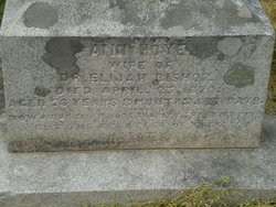
Mary Ann Hoye Drane
| Birth | : | 13 Oct 1805 Allegany County, Maryland, USA |
| Death | : | 28 Apr 1848 Allegany County, Maryland, USA |
| Burial | : | Hoye Family Cemetery - Crab Tree Bottom, McHenry, Garrett County, USA |
| Coordinate | : | 39.5642220, -79.3855000 |
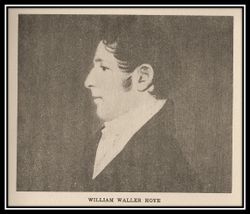
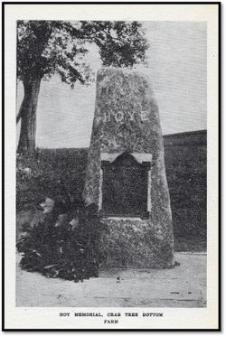
| Description | : | MARY ANN HOYE DRANE 1805-1848 BIOGRAPHICAL SKETCH COMPILED BY RONN E. FRIEND Daughter of William Waller Hoye (1768-1836) and Eleanor Slicer Hoye (1769-1812) BIRTH: 13 Oct 1805 Crab Tree Bottom Farm Sang Run, Allegany County (now Garrett), Maryland Death: 28 Apr 1848 McHenry, Allegany County (now Garrett), Maryland A vitim of tubeculosis BURIAL: 30 Apr 1848 Hoyes Cemetery, Crab Tree Bottom Sang Run, Allegany County (now Garrett), Maryland Buried near her sister Eliza Hoye Drane Married Marien Drane May 23, 1824. Of this union two children: 1.... Read More |
frequently asked questions (FAQ):
-
Where is Mary Ann Hoye Drane's memorial?
Mary Ann Hoye Drane's memorial is located at: Hoye Family Cemetery - Crab Tree Bottom, McHenry, Garrett County, USA.
-
When did Mary Ann Hoye Drane death?
Mary Ann Hoye Drane death on 28 Apr 1848 in Allegany County, Maryland, USA
-
Where are the coordinates of the Mary Ann Hoye Drane's memorial?
Latitude: 39.5642220
Longitude: -79.3855000
Family Members:
Parent
Siblings


Flowers:


Nearby Cemetories:
1. Hoye Family Cemetery - Crab Tree Bottom
McHenry, Garrett County, USA
Coordinate: 39.5642220, -79.3855000
2. Oak Grove Church of the Brethren Cemetery
McHenry, Garrett County, USA
Coordinate: 39.5694400, -79.3834300
3. Saint Dominic Catholic Cemetery
Hoyes, Garrett County, USA
Coordinate: 39.5868300, -79.3698600
4. Hoyes Cemetery
Garrett County, USA
Coordinate: 39.5905991, -79.3683014
5. Upper Sang Run Cemetery
McHenry, Garrett County, USA
Coordinate: 39.5717810, -79.4242430
6. Hoyes Run Cemetery
Garrett County, USA
Coordinate: 39.5313100, -79.4110900
7. Flatwood Cemetery
Accident, Garrett County, USA
Coordinate: 39.5923500, -79.3515400
8. Bumblebee Ridge Cemetery
McHenry, Garrett County, USA
Coordinate: 39.5774400, -79.3296800
9. Skiles Cemetery
Accident, Garrett County, USA
Coordinate: 39.5971570, -79.3439160
10. Bray Cemetery
Oakland, Garrett County, USA
Coordinate: 39.5006900, -79.3858100
11. Friend Cemetery
Oakland, Garrett County, USA
Coordinate: 39.4913500, -79.3778000
12. Glotfelty Farm Cemetery
McHenry, Garrett County, USA
Coordinate: 39.5708800, -79.2905500
13. Taylor-Sines Cemetery
Oakland, Garrett County, USA
Coordinate: 39.4894470, -79.4165480
14. Lake Ford Cemetery
Garrett County, USA
Coordinate: 39.5278015, -79.4792023
15. Ruckle Family Cemetery
Bittinger, Garrett County, USA
Coordinate: 39.5802600, -79.2821900
16. Bear Creek Church of the Brethren Cemetery
Accident, Garrett County, USA
Coordinate: 39.6213000, -79.3099800
17. Saint Paul's Old Cemetery
Accident, Garrett County, USA
Coordinate: 39.6287100, -79.3182100
18. Cherry Glade Cemetery
Accident, Garrett County, USA
Coordinate: 39.5827200, -79.2799500
19. Cranesville Cemetery
Cranesville, Preston County, USA
Coordinate: 39.5543920, -79.4929870
20. Glade Mennonite Cemetery
Bittinger, Garrett County, USA
Coordinate: 39.5826300, -79.2796700
21. Zion Lutheran Cemetery
Accident, Garrett County, USA
Coordinate: 39.6300510, -79.3129020
22. Rodeheaver Cemetery
Oakland, Garrett County, USA
Coordinate: 39.4804680, -79.3521300
23. Glendale Cemetery
Oakland, Garrett County, USA
Coordinate: 39.5085983, -79.2953033
24. Sisler Cemetery
Mountain Dale, Preston County, USA
Coordinate: 39.6081009, -79.4938965