
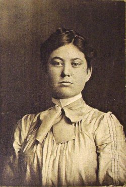
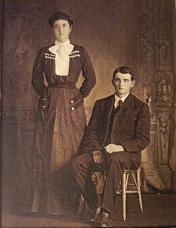
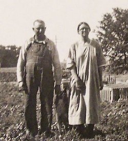
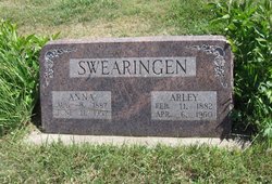
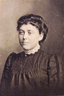
Eliza Ann Fudge Swearingen
| Birth | : | 8 Aug 1887 Jamestown, Cloud County, Kansas, USA |
| Death | : | 11 Jun 1957 Concordia, Cloud County, Kansas, USA |
| Burial | : | Anfield Cemetery and Crematorium, Anfield, Metropolitan Borough of Liverpool, England |
| Coordinate | : | 53.4354680, -2.9578100 |
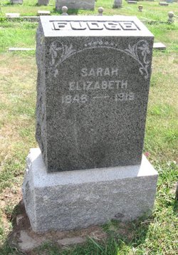
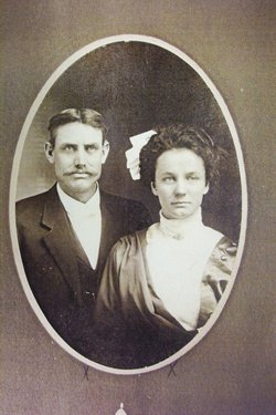
| Description | : | Eliza Ann Swearingen was born Anna E. Fudge on Aug. 8, 1887 in Cloud County the daughter of Jacob H. & Sarah Elizabeth Comer Fudge. She was married to Arley Swearingen at the Concordia E. U. B. church in February 1911. He preceded her in death on April 6, 1950. They lived on a farm in Cloud County until his death, then she moved to Concordia. |
frequently asked questions (FAQ):
-
Where is Eliza Ann Fudge Swearingen's memorial?
Eliza Ann Fudge Swearingen's memorial is located at: Anfield Cemetery and Crematorium, Anfield, Metropolitan Borough of Liverpool, England.
-
When did Eliza Ann Fudge Swearingen death?
Eliza Ann Fudge Swearingen death on 11 Jun 1957 in Concordia, Cloud County, Kansas, USA
-
Where are the coordinates of the Eliza Ann Fudge Swearingen's memorial?
Latitude: 53.4354680
Longitude: -2.9578100
Family Members:
Parent

Spouse

Siblings
Flowers:


Nearby Cemetories:
1. Anfield Cemetery and Crematorium
Anfield, Metropolitan Borough of Liverpool, England
Coordinate: 53.4354680, -2.9578100
2. St Luke Churchyard
Walton, Metropolitan Borough of Liverpool, England
Coordinate: 53.4396910, -2.9671400
3. St. Mary's Cemetery
Kirkdale, Metropolitan Borough of Liverpool, England
Coordinate: 53.4323690, -2.9752500
4. St Mary the Virgin Churchyard
Walton, Metropolitan Borough of Liverpool, England
Coordinate: 53.4464930, -2.9673330
5. St. George Churchyard
Everton, Metropolitan Borough of Liverpool, England
Coordinate: 53.4252810, -2.9713940
6. Kirkdale Goal Cemetery
Kirkdale, Metropolitan Borough of Liverpool, England
Coordinate: 53.4361110, -2.9802780
7. Rice Lane Jewish Cemetery
Walton, Metropolitan Borough of Liverpool, England
Coordinate: 53.4521700, -2.9590600
8. St. Anthony's Churchyard
Liverpool, Metropolitan Borough of Liverpool, England
Coordinate: 53.4223190, -2.9815350
9. Liverpool Necropolis
Everton, Metropolitan Borough of Liverpool, England
Coordinate: 53.4146670, -2.9621830
10. St. Alexander Church
Bootle, Metropolitan Borough of Sefton, England
Coordinate: 53.4401090, -2.9922250
11. Green Lane Jewish Cemetery
Liverpool, Metropolitan Borough of Liverpool, England
Coordinate: 53.4234720, -2.9280170
12. Everton Cemetery
Everton, Metropolitan Borough of Liverpool, England
Coordinate: 53.4555430, -2.9442480
13. Long Lane Jewish Cemetery
Liverpool, Metropolitan Borough of Liverpool, England
Coordinate: 53.4550140, -2.9420480
14. Walton Park Cemetery
Walton, Metropolitan Borough of Liverpool, England
Coordinate: 53.4564370, -2.9695960
15. St Martin-in-the-Fields Churchyard
Liverpool, Metropolitan Borough of Liverpool, England
Coordinate: 53.4210110, -2.9877860
16. St. Anne's Churchyard
Liverpool, Metropolitan Borough of Liverpool, England
Coordinate: 53.4149050, -2.9782840
17. Deane Road Cemetery
Liverpool, Metropolitan Borough of Liverpool, England
Coordinate: 53.4114570, -2.9460500
18. Brunswick Chapel
Liverpool, Metropolitan Borough of Liverpool, England
Coordinate: 53.4111280, -2.9675500
19. Holy Trinity Churchyard
Liverpool, Metropolitan Borough of Liverpool, England
Coordinate: 53.4117490, -2.9759560
20. Friends Burial Ground (Defunct)
Liverpool, Metropolitan Borough of Liverpool, England
Coordinate: 53.4111670, -2.9795830
21. Saint Anne Churchyard
Stanley, Metropolitan Borough of Liverpool, England
Coordinate: 53.4158800, -2.9238300
22. St. Mary's Churchyard
Edge Hill, Metropolitan Borough of Liverpool, England
Coordinate: 53.4065000, -2.9561600
23. St. Mary's Churchyard
Bootle, Metropolitan Borough of Sefton, England
Coordinate: 53.4492620, -3.0006520
24. West Derby Cemetery
West Derby, Metropolitan Borough of Liverpool, England
Coordinate: 53.4513790, -2.9154630