
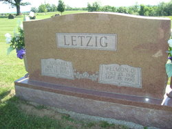
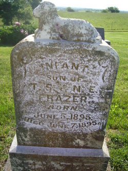
Elizabeth Annabel Frazer Letzig
| Birth | : | 1 Mar 1918 Russellville, Cole County, Missouri, USA |
| Death | : | 14 Oct 2007 Richmond, Ray County, Missouri, USA |
| Burial | : | Sunset Lawn Chapel of the Chimes Memorial Park, Sacramento, Sacramento County, USA |
| Coordinate | : | 38.6514816, -121.4384842 |
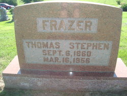
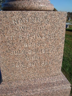
| Description | : | E. Annabel Letzig, 89, of Richmond, Mo., died at 5:20 p.m. Sunday, October 14, 2007, at the Ray County Memorial Hospital in Richmond. Mrs. Letzig was born March 1, 1918, in Russellville, Mo., to Thomas Stephen and Nannie Elizabeth (Wollard) Frazer. She married Welmon Otto Letzig of Richmond on Feb. 19, 1938; he preceded her in death on Sept. 18, 1990. Survivors include one son and daughter-in-law, Welmon Frazer and Patricia C. Letzig of Richmond; two daughters and sons-in-law, Virginia Frances and Donald F. Miller of Richmond and Barbara Jean and Mike Nolker of Richmond; four grandchildren, Vicki Johnson, Terry... Read More |
frequently asked questions (FAQ):
-
Where is Elizabeth Annabel Frazer Letzig's memorial?
Elizabeth Annabel Frazer Letzig's memorial is located at: Sunset Lawn Chapel of the Chimes Memorial Park, Sacramento, Sacramento County, USA.
-
When did Elizabeth Annabel Frazer Letzig death?
Elizabeth Annabel Frazer Letzig death on 14 Oct 2007 in Richmond, Ray County, Missouri, USA
-
Where are the coordinates of the Elizabeth Annabel Frazer Letzig's memorial?
Latitude: 38.6514816
Longitude: -121.4384842
Family Members:
Parent
Spouse

Siblings

Flowers:


Nearby Cemetories:
1. Kim Quang Temple Columbarium
Sacramento, Sacramento County, USA
Coordinate: 38.5996600, -121.3904700
2. Saint Marks Methodist Church Memorial Tree
Sacramento, Sacramento County, USA
Coordinate: 38.6076500, -121.3750680
3. Holy Ascension Russian Orthodox Cemetery
Sacramento, Sacramento County, USA
Coordinate: 38.5846212, -121.4936736
4. Saint Michaels Episcopal Church Columbarium
Carmichael, Sacramento County, USA
Coordinate: 38.6042800, -121.3547200
5. New Helvetia Cemetery (Defunct)
Sacramento, Sacramento County, USA
Coordinate: 38.5731600, -121.4639900
6. Trinity Episcopal Cathedral Columbarium
Sacramento, Sacramento County, USA
Coordinate: 38.5705500, -121.4723770
7. Union Cemetery
Roseville, Placer County, USA
Coordinate: 38.7302600, -121.3924200
8. California State Capitol
Sacramento, Sacramento County, USA
Coordinate: 38.5760994, -121.4931488
9. Carmichael Presbyterian Church Columbarium
Carmichael, Sacramento County, USA
Coordinate: 38.6179500, -121.3324500
10. East Lawn Memorial Park
Sacramento, Sacramento County, USA
Coordinate: 38.5612960, -121.4492760
11. Sierra Hills Pet Cemetery
Sacramento, Sacramento County, USA
Coordinate: 38.6863500, -121.3305300
12. Sierra Hills Memorial Park
Sacramento, Sacramento County, USA
Coordinate: 38.6843987, -121.3281021
13. National Shrine of Our Lady of Guadalupe Crypt
Sacramento, Sacramento County, USA
Coordinate: 38.5704800, -121.5014400
14. Buddhist Church of Sacramento Nokotsudo
Sacramento, Sacramento County, USA
Coordinate: 38.5639300, -121.4978400
15. Calvary Catholic Cemetery and Mausoleum
Sacramento, Sacramento County, USA
Coordinate: 38.6937180, -121.3233109
16. Saint Joseph Cemetery
Sacramento, Sacramento County, USA
Coordinate: 38.5574989, -121.4835968
17. Sacramento City Cemetery
Sacramento, Sacramento County, USA
Coordinate: 38.5636864, -121.5009537
18. Sunset Hill Cemetery
Sacramento, Sacramento County, USA
Coordinate: 38.5608000, -121.5037300
19. Masonic Lawn Cemetery
Sacramento, Sacramento County, USA
Coordinate: 38.5604720, -121.5032600
20. Odd Fellows Lawn Cemetery and Mausoleum
Sacramento, Sacramento County, USA
Coordinate: 38.5585000, -121.5011000
21. Pho Minh Temple Columbarium
Sacramento, Sacramento County, USA
Coordinate: 38.5340100, -121.4769000
22. Saint Mary's Catholic Cemetery and Mausoleum
Sacramento, Sacramento County, USA
Coordinate: 38.5298900, -121.4261200
23. Sacramento County Hospital Cemetery
Sacramento, Sacramento County, USA
Coordinate: 38.5289300, -121.4239100
24. Fair Oaks Cemetery
Fair Oaks, Sacramento County, USA
Coordinate: 38.6501167, -121.2792000