
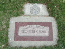
Elizabeth Collingwood “Bessie” Jackson Boyd
| Birth | : | 18 Feb 1877 La Crescent, Houston County, Minnesota, USA |
| Death | : | 26 Mar 1961 Wenatchee, Chelan County, Washington, USA |
| Burial | : | New Hope Cemetery, Liberty, Clay County, USA |
| Coordinate | : | 39.2392006, -94.4255981 |
| Plot | : | Row 10, Alley 6 Block 5, Lot 1 |
| Inscription | : | OES symbol |
| Description | : | Note: Wrong birth year on headstone. Mrs. Elizabeth Collingwood Boyd, 81, of 1022 Amherst, a pioneer resident of North Central Washington, died at home Sunday following an extended illness. Mrs. Boyd was born Feb. 18, 1880 at La Crescent, Minn., and spent her early life in South Dakota. In 1902 she came to Chelan where she married Elmer L Boyd. She moved to Wenatchee in 1952. She was a past worthy matron of the Eastern Star, a past noble grand of the Rebekah Lodge, and a member of the Methodist Church, all in Chelan. Her husband died... Read More |
frequently asked questions (FAQ):
-
Where is Elizabeth Collingwood “Bessie” Jackson Boyd's memorial?
Elizabeth Collingwood “Bessie” Jackson Boyd's memorial is located at: New Hope Cemetery, Liberty, Clay County, USA.
-
When did Elizabeth Collingwood “Bessie” Jackson Boyd death?
Elizabeth Collingwood “Bessie” Jackson Boyd death on 26 Mar 1961 in Wenatchee, Chelan County, Washington, USA
-
Where are the coordinates of the Elizabeth Collingwood “Bessie” Jackson Boyd's memorial?
Latitude: 39.2392006
Longitude: -94.4255981
Family Members:
Parent
Spouse
Flowers:


Nearby Cemetories:
1. New Hope Cemetery
Liberty, Clay County, USA
Coordinate: 39.2392006, -94.4255981
2. Fairview Cemetery
Liberty, Clay County, USA
Coordinate: 39.2428017, -94.4238968
3. George Wymore Gravesite
Clay County, USA
Coordinate: 39.2471100, -94.4191200
4. Second Baptist Church Cemetery
Liberty, Clay County, USA
Coordinate: 39.2465860, -94.4172780
5. Mount Memorial Cemetery
Liberty, Clay County, USA
Coordinate: 39.2489014, -94.4123383
6. Odd Fellows Cemetery
Liberty, Clay County, USA
Coordinate: 39.2294500, -94.4056100
7. Baker Cemetery
Liberty, Clay County, USA
Coordinate: 39.2678700, -94.4171600
8. Adkins Family Cemetery
Liberty, Callaway County, USA
Coordinate: 39.2206840, -94.4579870
9. Adkins Family Cemetery
Liberty, Clay County, USA
Coordinate: 39.2206840, -94.4579870
10. McQuiddy Cemetery
Kansas City, Clay County, USA
Coordinate: 39.2504437, -94.4658178
11. Arthur Cemetery
Liberty, Clay County, USA
Coordinate: 39.2083527, -94.4501364
12. Lincoln Cemetery
Liberty, Clay County, USA
Coordinate: 39.2788600, -94.4198900
13. Davidson Cemetery
Kansas City, Clay County, USA
Coordinate: 39.2332993, -94.4794006
14. Little Shoal Cemetery
Liberty, Clay County, USA
Coordinate: 39.2736015, -94.4646988
15. Glenridge Cemetery
Liberty, Clay County, USA
Coordinate: 39.2775002, -94.3927994
16. Keller Cemetery
Clay County, USA
Coordinate: 39.2415200, -94.3627900
17. Pence Cemetery
Pleasant Valley, Clay County, USA
Coordinate: 39.2308006, -94.4899979
18. Weber-Irminger Cemetery
Liberty, Clay County, USA
Coordinate: 39.2266400, -94.3573900
19. Pickett Cemetery
Liberty, Clay County, USA
Coordinate: 39.2963982, -94.4285965
20. Nebo Cemetery
South Liberty, Clay County, USA
Coordinate: 39.2160072, -94.3571701
21. Robertson Cemetery
Clay County, USA
Coordinate: 39.2952995, -94.3964005
22. McQuiddy Family Cemetery
Liberty, Clay County, USA
Coordinate: 39.2639000, -94.3519000
23. Chandler Church Cemetery
Chandler, Clay County, USA
Coordinate: 39.2986412, -94.3818207
24. Wade Cemetery
Liberty, Clay County, USA
Coordinate: 39.3106900, -94.4002850