| Birth | : | 1795 |
| Death | : | 10 Mar 1855 Canterbury, City of Canterbury, Kent, England |
| Burial | : | St Michael and All Angels Church, Harbledown, City of Canterbury, England |
| Coordinate | : | 51.2824590, 1.0556800 |
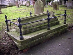
| Plot | : | Possibly in courtyard near her husband, Thomas Thorpe DeLasaux |
| Description | : | Thomas Thorpe De Lasaux, "England Marriages, 1538–1973" Name: Thomas Thorpe De Lasaux Spouse's Name: Elizabeth Cock Event Date: 05 May 1817 Event Place: St. Botolph Aldgate, London, England Marital Status: Single Spouse's Marital Status: Single ~~~~~~ List of children of Elizabeth (nee Cox/Cock) and Thomas Thorpe DeLasaux in their birth order. Information is from the Ancestral File database for Lucy Pauli (nee DeLasaux) Cooper, other DeLasaux Ancestral Files and England Marriages, 1538–1973. Note that some of the below-listed birth and/or death dates are in question and do not correspond with known birth/death/marriage records. Updates are pending and dates will be corrected as more records... Read More |
frequently asked questions (FAQ):
-
Where is Elizabeth Cox Cock DeLasaux's memorial?
Elizabeth Cox Cock DeLasaux's memorial is located at: St Michael and All Angels Church, Harbledown, City of Canterbury, England.
-
When did Elizabeth Cox Cock DeLasaux death?
Elizabeth Cox Cock DeLasaux death on 10 Mar 1855 in Canterbury, City of Canterbury, Kent, England
-
Where are the coordinates of the Elizabeth Cox Cock DeLasaux's memorial?
Latitude: 51.2824590
Longitude: 1.0556800
Family Members:
Spouse
Children
Flowers:
Nearby Cemetories:
1. St Michael and All Angels Church
Harbledown, City of Canterbury, England
Coordinate: 51.2824590, 1.0556800
2. St Nicholas Hospital Church
Harbledown, City of Canterbury, England
Coordinate: 51.2828200, 1.0536580
3. Canterbury City Cemetery
Canterbury, City of Canterbury, England
Coordinate: 51.2843285, 1.0637640
4. St. Dunstan Churchyard
Canterbury, City of Canterbury, England
Coordinate: 51.2836820, 1.0707800
5. Canterbury Jewish Cemetery
Canterbury, City of Canterbury, England
Coordinate: 51.2846135, 1.0706660
6. Westgate Gardens
Canterbury, City of Canterbury, England
Coordinate: 51.2805250, 1.0745040
7. St Nicholas Churchyard
Thanington-Without, City of Canterbury, England
Coordinate: 51.2703550, 1.0544190
8. Holy Cross Church
Canterbury, City of Canterbury, England
Coordinate: 51.2811350, 1.0755710
9. Wincheap Non-Conformist Burial Ground
Canterbury, City of Canterbury, England
Coordinate: 51.2718430, 1.0672940
10. St. Mildred with St. Mary de Castro Church
Canterbury, City of Canterbury, England
Coordinate: 51.2764810, 1.0743320
11. St Peters Methodist Church
Canterbury, City of Canterbury, England
Coordinate: 51.2801720, 1.0771480
12. St Peter the Apostle Churchyard
Canterbury, City of Canterbury, England
Coordinate: 51.2807260, 1.0775370
13. All Saints Church Demolished
Canterbury, City of Canterbury, England
Coordinate: 51.2802800, 1.0783450
14. St Mary Breadman Church Demolished
Canterbury, City of Canterbury, England
Coordinate: 51.2798870, 1.0784520
15. St Mary de Castro Churchyard
Canterbury, City of Canterbury, England
Coordinate: 51.2762400, 1.0766820
16. St Margaret's Churchyard
Canterbury, City of Canterbury, England
Coordinate: 51.2781780, 1.0795840
17. Dane John Gardens
Canterbury, City of Canterbury, England
Coordinate: 51.2754210, 1.0780390
18. St Mary Bredin Old Church (Defunct)
Canterbury, City of Canterbury, England
Coordinate: 51.2773455, 1.0803962
19. Canterbury Cathedral
Canterbury, City of Canterbury, England
Coordinate: 51.2796936, 1.0826840
20. St Mary Magdalene Church Demolished
Canterbury, City of Canterbury, England
Coordinate: 51.2784510, 1.0830170
21. St. John the Baptist Hospital Chapelyard
Canterbury, City of Canterbury, England
Coordinate: 51.2832713, 1.0837677
22. St George's Church Demolished
Canterbury, City of Canterbury, England
Coordinate: 51.2773770, 1.0827380
23. St Gregory's Priory (defunct)
Canterbury, City of Canterbury, England
Coordinate: 51.2831127, 1.0855358
24. St Mary Northgate Cemetery
Canterbury, City of Canterbury, England
Coordinate: 51.2811320, 1.0859300


